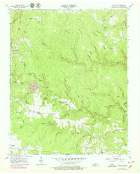
1954 Map of Stockton
USGS Topo · Published 1979About this map
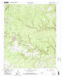
Stockton and Armathwaite serve as the primary nodes of settlement in this 1954 survey of Fentress County, where the landscape is defined by the deep dissection of the Cumberland Plateau. The map reveals a community structured around its ridge-top schools and scattered family burial grounds, such as Alticrest Sch and the Royalston Cem. The drainage patterns of North White Oak Creek and its many tributaries, including Mill Seat Creek and Lick Branch, dictate the location of historic homesteads and small-scale agriculture. A notable 1970s photorevision highlights industrial or topographical changes near East Jamestown, while landmarks like The Narrows and Tar Kiln Ridge underscore the geological complexity of the Big South Fork watershed area.
Find a feature on this map
57 named features on this map. Tap any name to fly to it.
Don’t see what you’re looking for? This feature index may not catch every label — zoom into the map to look around manually.
Map Details
Editions of this 1954 Stockton Map
6 editions found
Other maps of this area

1895 · Wartburg
USGS Topo · 1:125,000

1896 · Wartburg
USGS Topo · 1:125,000

1934 · Barthell
USGS Topo · 1:62,500

1934 · Pall Mall
USGS Topo · 1:62,500

1952 · Honey Creek
USGS Topo · 1:24,000

1952 · Rugby
USGS Topo · 1:24,000

1954 · Stockton
USGS Topo · 1:24,000

1954 · Burrville
USGS Topo · 1:24,000

1954 · Jamestown
USGS Topo · 1:24,000

1954 · Grimsley
USGS Topo · 1:24,000