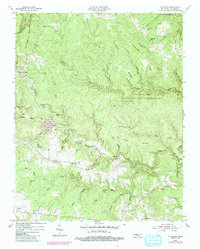
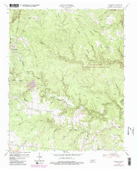
1954 Map of Stockton
USGS Topo · Published 1984About this map
Stockton sits at the heart of this Tennessee landscape, a rural community defined by the intricate winding of North White Oak Creek and the deep dissection of the plateau. To the north, the terrain becomes increasingly complex within the Big South Fork National River And Recreation Area, where Laurel Fork and Spruce Creek carve deep into the sandstone. The settlement pattern follows the higher ground along Hatfield Ridge and Crockett Ridge, with schools like Alticrest Sch and Stockton Sch serving as local hubs. Family history is etched into the land through numerous small burial grounds, including the Royalston Cem and Potter Cem. A notable geographic feature, The Narrows, highlights the constricted passage of water between towering ridges, while the small crossroads of Armathwaite and Allardt anchor the southern reaches of the quadrangle.
Find a feature on this map
68 named features on this map. Tap any name to fly to it.
Don’t see what you’re looking for? This feature index may not catch every label — zoom into the map to look around manually.
Map Details
Editions of this 1954 Stockton Map
6 editions found
Other maps of this area

1895 · Wartburg
USGS Topo · 1:125,000

1896 · Wartburg
USGS Topo · 1:125,000

1934 · Barthell
USGS Topo · 1:62,500

1934 · Pall Mall
USGS Topo · 1:62,500

1952 · Honey Creek
USGS Topo · 1:24,000

1952 · Rugby
USGS Topo · 1:24,000

1954 · Stockton
USGS Topo · 1:24,000

1954 · Burrville
USGS Topo · 1:24,000

1954 · Jamestown
USGS Topo · 1:24,000

1954 · Grimsley
USGS Topo · 1:24,000