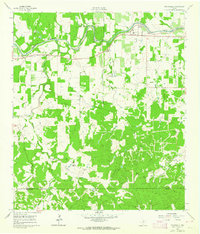
1961 Map of Stonewall
USGS Topo · Published 1964About this map
The Pedernales River flows through the heart of the Texas Hill Country in this early 1960s survey, anchoring a landscape defined by generational family ranches and small German-settled communities. The LBJ Ranch is prominent along the river's northern bank, while the primary settlement at Stonewall serves as a local hub with its St Francis Xavier Ch and Stonewall Cem. The map reveals a deeply rooted rural infrastructure, from the South Grape Creek Sch to the scattered holdings of the Gellermann Ranch and Weinheimer Ranch.
Find a feature on this map
42 named features on this map. Tap any name to fly to it.
Don’t see what you’re looking for? This feature index may not catch every label — zoom into the map to look around manually.
Map Details
Editions of this 1961 Stonewall Map
Other maps of this area

1894 · Fredericksburg
USGS Topo · 1:125,000

1954 · Llano
USGS Topo · 1:250,000

1955 · Llano
USGS Topo · 1:250,000

1956 · Llano
USGS Topo · 1:250,000

1961 · Stonewall
USGS Topo · 1:24,000

1961 · Hye
USGS Topo · 1:24,000

1961 · Cave Creek School
USGS Topo · 1:24,000

1961 · Rocky Creek
USGS Topo · 1:24,000
1963 · Crabapple Creek
USGS Topo · 1:24,000

1963 · Whitworth Ranch
USGS Topo · 1:24,000