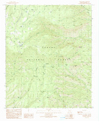
1991 Map of Strayhorse
USGS Topo · Published 1991About this map
Apache National Forest provides the setting for this remote high-altitude landscape, where land management and recreation facilities define the human presence. The Strayhorse F/S Station and the Blue Peak Lookout Tower highlight the importance of fire observation and forestry operations in this rugged interior. The terrain is marked by a complex network of canyons and peaks, including Raspberry Peak and Sawed Off Mountain, which overlook deep drainages like McKittrick Creek and East Eagle Creek.
Find a feature on this map
47 named features on this map. Tap any name to fly to it.
Don’t see what you’re looking for? This feature index may not catch every label — zoom into the map to look around manually.
Map Details
Editions of this 1991 Strayhorse Map
2 editions found
Other maps of this area

1913 · Morenci
USGS Topo · 1:125,000

1915 · Morenci
USGS Topo · 1:125,000

1922 · Nutrioso
USGS Topo · 1:125,000

1954 · Clifton
USGS Topo · 1:250,000

1957 · Clifton
USGS Topo · 1:250,000

1958 · Clifton
USGS Topo · 1:250,000

1958 · Hannagan Meadow
USGS Topo · 1:62,500

1961 · Blue
USGS Topo · 1:62,500

1962 · Clifton
USGS Topo · 1:250,000

1967 · Robinson Mesa
USGS Topo · 1:24,000