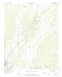
1956 Map of Stringtown
USGS Topo · Published 1975About this map
Black Knob Ridge forms a prominent geological spine through this mid-century Oklahoma landscape, separating the valley of North Boggy Creek from the surrounding uplands. The settlement of Stringtown serves as a central hub, positioned where the Kansas Missouri Texas line cuts through the terrain. The map records a transition in rural education, noting the Boggy Bend School and the already West Tellico School (Abandoned), which reflects shifting population centers in Atoka County.
Find a feature on this map
34 named features on this map. Tap any name to fly to it.
Don’t see what you’re looking for? This feature index may not catch every label — zoom into the map to look around manually.
Map Details
Editions of this 1956 Stringtown Map
4 editions found

Other maps of this area

1896 · Coalgate
USGS Topo · 1:125,000

1898 · McAlester
USGS Topo · 1:125,000

1899 · Coalgate
USGS Topo · 1:125,000

1899 · Atoka
USGS Topo · 1:125,000

1900 · Atoka
USGS Topo · 1:125,000

1900 · Coalgate
USGS Topo · 1:125,000

1901 · Antlers
USGS Topo · 1:125,000

1909 · Mc Alester
USGS Topo · 1:125,000

1912 · Antlers
USGS Topo · 1:125,000

1925 · Antlers
USGS Topo · 1:125,000