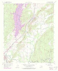
1956 Map of Stringtown
USGS Topo · Published 1979About this map
Atoka Reservoir dominates the western landscape of this mid-century survey, its planned water levels recorded as the city of Oklahoma City expanded its regional utility reach. The terrain is defined by the sharp verticality of Black Knob Ridge and the Missouri Kansas Texas railroad corridor, which serves the community of Stringtown. The presence of the Confederate Cem near the southern boundary reflects the area's deeper heritage, while the mapping of the West Tellico Sch (Abandoned) and Boggy Bend Sch captures a transition in local education and rural settlement patterns. From the rocky elevations at Grants Gap to the winding bottomlands of Muddy Boggy Creek, the map details a region where infrastructure like the Armory and Waterworks stands alongside traditional creek-side homesteads and rugged prairie gaps.
Find a feature on this map
35 named features on this map. Tap any name to fly to it.
Don’t see what you’re looking for? This feature index may not catch every label — zoom into the map to look around manually.
Map Details
Editions of this 1956 Stringtown Map
4 editions found

Other maps of this area

1896 · Coalgate
USGS Topo · 1:125,000

1898 · McAlester
USGS Topo · 1:125,000

1899 · Coalgate
USGS Topo · 1:125,000

1899 · Atoka
USGS Topo · 1:125,000

1900 · Atoka
USGS Topo · 1:125,000

1900 · Coalgate
USGS Topo · 1:125,000

1901 · Antlers
USGS Topo · 1:125,000

1909 · Mc Alester
USGS Topo · 1:125,000

1912 · Antlers
USGS Topo · 1:125,000

1925 · Antlers
USGS Topo · 1:125,000