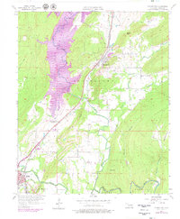
1956 Map of Stringtown
USGS Topo · Published 1979About this map
Atoka Reservoir dominates the western half of this landscape, its planned elevation and pool area shown as they appeared in the late 1970s following its creation. The topography is defined by the prominent Black Knob Ridge, which cuts diagonally across the center, separating the reservoir's basin from the valley of Muddy Boggy Creek to the south. The city of Stringtown serves as a central hub, situated along the Missouri-Kansas-Texas railroad line.
Find a feature on this map
33 named features on this map. Tap any name to fly to it.
Don’t see what you’re looking for? This feature index may not catch every label — zoom into the map to look around manually.
Map Details
Editions of this 1956 Stringtown Map
4 editions found

Other maps of this area

1896 · Coalgate
USGS Topo · 1:125,000

1898 · McAlester
USGS Topo · 1:125,000

1899 · Coalgate
USGS Topo · 1:125,000

1899 · Atoka
USGS Topo · 1:125,000

1900 · Atoka
USGS Topo · 1:125,000

1900 · Coalgate
USGS Topo · 1:125,000

1901 · Antlers
USGS Topo · 1:125,000

1909 · Mc Alester
USGS Topo · 1:125,000

1912 · Antlers
USGS Topo · 1:125,000

1925 · Antlers
USGS Topo · 1:125,000