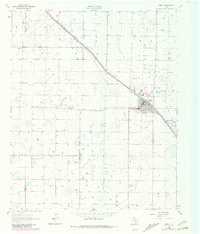
1962 Map of Sudan
USGS Topo · Published 1981About this map
The High Plains of the Texas Panhandle are defined here by the agricultural grid and the influence of the Panhandle and Santa Fe railroad. The town of Sudan serves as the primary hub, situated along the rail line that cuts diagonally across the landscape. This 1962 survey, with revisions from 1979, illustrates the town's infrastructure, including the Sudan Airfield and a local substation that supported the area's growth.
Find a feature on this map
9 named features on this map. Tap any name to fly to it.
Don’t see what you’re looking for? This feature index may not catch every label — zoom into the map to look around manually.
Map Details
Editions of this 1962 Sudan Map
2 editions found
Other maps of this area

1954 · Clovis
USGS Topo · 1:250,000

1954 · Brownfield
USGS Topo · 1:250,000

1958 · Brownfield
USGS Topo · 1:250,000

1958 · Clovis
USGS Topo · 1:250,000

1962 · Brownfield
USGS Topo · 1:250,000

1962 · Muleshoe
USGS Topo · 1:24,000

1962 · Needmore
USGS Topo · 1:24,000

1962 · Amherst
USGS Topo · 1:24,000

1962 · Sudan
USGS Topo · 1:24,000

1962 · Muleshoe NE
USGS Topo · 1:24,000