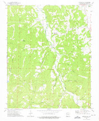
1973 Map of Sulphur City
USGS Topo · Published 1976About this map
Sulphur City and the winding course of the Middle Fork White River define the local topography of eastern Washington County in the early 1970s. The landscape is marked by numerous family and community landmarks, including Salem Cem, Kings Cem, and Reese Cem, which offer significant value for genealogical research in this part of Arkansas. Small settlements like Arnett, Wyola, and Hicks are connected by a network of valley roads and hollows, such as Lutman Hollow and Richardson Hollow. Subterranean features also characterize the region, with Fincher Cave, Bassett Cave, and Richardson Cave noted among the timbered ridges. The presence of the Low Gap Ch and its accompanying Low Gap Ch Cem further illustrates the established rural community structure centered around the river forks and mountain gaps like Snyder Mountain.
Find a feature on this map
45 named features on this map. Tap any name to fly to it.
Don’t see what you’re looking for? This feature index may not catch every label — zoom into the map to look around manually.
Map Details
Editions of this 1973 Sulphur City Map
3 editions found
Other maps of this area

1898 · Winslow
USGS Topo · 1:125,000

1899 · Fayetteville
USGS Topo · 1:125,000

1900 · Eureka Springs
USGS Topo · 1:125,000

1901 · Winslow
USGS Topo · 1:125,000

1901 · Eureka Springs
USGS Topo · 1:125,000

1901 · Fayetteville
USGS Topo · 1:125,000

1904 · Fayetteville
USGS Topo · 1:125,000

1943 · St. Paul
USGS Topo · 1:62,500

1945 · Harrison
USGS Topo · 1:250,000

1946 · St. Paul
USGS Topo · 1:62,500