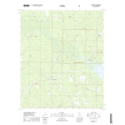
2020 Map of Summerfield
USGS Topo · Published 2020About this map
Summerfield serves as the central hub of this North Louisiana landscape, situated at the junction of several local routes like Beauty Shop Rd and Horseshoe Rd. The surrounding Claiborne Parish terrain is defined by its deep spiritual and communal roots, evidenced by numerous burial sites including Summerfield Cem, Mount Hebron Cem, and Hickory Grove Cem. These cemeteries are often tucked between the dense woodlands of the Kisatchie National Forest and the winding tributaries of the Corney Bayou watershed. To the northeast, Scottsville sits near the forest boundary, while the land is crisscrossed by named watercourses like Barber Cr, Panther Cr, and Sugar Cr. The presence of roads like Thurmon School Rd and Fellowship Rd points to the early social structure of this rural timber and farming region.
Find a feature on this map
55 named features on this map. Tap any name to fly to it.
Don’t see what you’re looking for? This feature index may not catch every label — zoom into the map to look around manually.
Map Details
Editions of this 2020 Summerfield Map
This is the sole edition of this map. No revisions or reprints were ever made.
Other maps of this area

1927 · El Dorado
USGS Topo · 1:62,500

1930 · El Dorado
USGS Topo · 1:62,500

1951 · Summerfield
USGS Topo · 1:62,500

1951 · Bernice
USGS Topo · 1:62,500

1951 · El Dorado
USGS Topo · 1:62,500

1953 · El Dorado
USGS Topo · 1:250,000

1955 · Shreveport
USGS Topo · 1:250,000

1956 · Shreveport
USGS Topo · 1:250,000

1957 · El Dorado
USGS Topo · 1:250,000

1958 · El Dorado
USGS Topo · 1:250,000