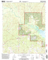
2003 Map of Summerfield
USGS Topo · Published 2005About this map
Summerfield serves as the primary hub of this landscape at the intersection of local roads in Claiborne Parish. The topography is defined by the winding course of Corney Bayou and its numerous tributaries, including Three Creeks and Little Corney Bayou, which drain into the expansive Corney Lake in the eastern sector. A significant portion of the area is protected within the Kisatchie National Forest, where the terrain remains primarily wooded and dissected by smaller streams like Greer Creek.
Find a feature on this map
30 named features on this map. Tap any name to fly to it.
Don’t see what you’re looking for? This feature index may not catch every label — zoom into the map to look around manually.
Map Details
Editions of this 2003 Summerfield Map
This is the sole edition of this map. No revisions or reprints were ever made.
Other maps of this area

1927 · El Dorado
USGS Topo · 1:62,500

1930 · El Dorado
USGS Topo · 1:62,500

1951 · Summerfield
USGS Topo · 1:62,500

1951 · Bernice
USGS Topo · 1:62,500

1951 · El Dorado
USGS Topo · 1:62,500

1953 · El Dorado
USGS Topo · 1:250,000

1955 · Shreveport
USGS Topo · 1:250,000

1956 · Shreveport
USGS Topo · 1:250,000

1957 · El Dorado
USGS Topo · 1:250,000

1958 · El Dorado
USGS Topo · 1:250,000