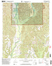
2002 Map of Summerfield
USGS Topo · Published 2003About this map
Summerfield and its surrounding countryside are defined by a mix of public forest lands and small-scale settlements across the border of Perry and Dallas counties. The northern portion of the quadrangle is dominated by the Talladega National Forest, where steep, wooded ridges overlook Oakmulgee Creek and its tributaries. Local history is anchored by several community hubs such as Stonewall and Perryville, and a high density of rural religious sites. Landmarks like College Hill Ch and Mary Etta Ch, alongside their associated cemeteries, reflect the long-standing family foundations in this part of Alabama. To the east, Paul M Grist State Park provides a notable recreational footprint. The landscape also reveals modern infrastructure, including several pipelines and a Gaging Sta along the creek, indicating the region's managed natural resources.
Find a feature on this map
32 named features on this map. Tap any name to fly to it.
Don’t see what you’re looking for? This feature index may not catch every label — zoom into the map to look around manually.
Map Details
Editions of this 2002 Summerfield Map
This is the sole edition of this map. No revisions or reprints were ever made.
Other maps of this area

1891 · Clanton
USGS Topo · 1:125,000

1953 · Montgomery
USGS Topo · 1:250,000

1956 · Montgomery
USGS Topo · 1:250,000

1957 · Montgomery
USGS Topo · 1:250,000

1957 · Benton
USGS Topo · 1:62,500

1958 · Selma
USGS Topo · 1:62,500

1958 · Selma
USGS Topo · 1:24,000

1959 · Plantersville
USGS Topo · 1:62,500

1959 · Summerfield
USGS Topo · 1:62,500

1975 · Selma NW
USGS Topo · 1:24,000