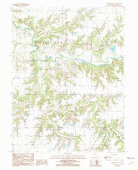
1982 Map of Summerville
USGS Topo · Published 1982About this map
Macoupin Creek meanders through the central landscape of this Macoupin County region, defining the drainage patterns for numerous tributaries like Cheste R F I E L D Creek and Coop Branch. The 1982 topography reveals a rural transition where the undulating creek valleys meet the gridded upland prairies of central Illinois. Settlement is concentrated in small pockets such as Summerville and the outskirts of Shipman, while landmarks like Mowens Lake and Bullard Lake suggest localized water management or recreational impoundments within the agricultural expanse. The presence of several Cem labels near the township borders of Chesterfield and Polk provides specific points of interest for genealogists tracing families in these rural townships during the late twentieth century.
Find a feature on this map
16 named features on this map. Tap any name to fly to it.
Don’t see what you’re looking for? This feature index may not catch every label — zoom into the map to look around manually.
Map Details
Editions of this 1982 Summerville Map
This is the sole edition of this map. No revisions or reprints were ever made.
Other maps of this area

1912 · Gillespie
USGS Topo · 1:62,500

1915 · Gillespie
USGS Topo · 1:62,500

1923 · Carlinville
USGS Topo · 1:48,000

1925 · Carlinville
USGS Topo · 1:62,500

1925 · Brighton
USGS Topo · 1:62,500

1928 · Brighton
USGS Topo · 1:62,500

1931 · Carlinville
USGS Topo · 1:62,500

1932 · Greenfield
USGS Topo · 1:62,500

1948 · Quincy
USGS Topo · 1:250,000

1956 · Quincy
USGS Topo · 1:250,000