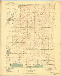
1950 Map of Sumner
USGS Topo · Published 1950About this map
Sumner serves as the primary hub in this Missouri river basin landscape, situated at the intersection of the Wabash and Chicago Burlington and Quincy railroads. The topography is defined by the convergence of several waterways, including Locust Creek and Tough Branch, which flow toward the expansive wetlands of the Swan Lake National Wildlife Refuge and Silver Lake at the southern edge. This 1950 edition captures the rural layout of Chariton and Linn Counties before modern land-use changes, preserving the locations of local landmarks such as Kaye Sch and the Lookout Tower. A network of levees along the creeks indicates the ongoing management of this flood-prone terrain, while family-named sites like Harlow Fay Lakes and the settlement at Cunningham provide valuable coordinates for local history research. Genealogists will find interest in the documented locations of several burial grounds, including Lakeside Cemetery and Purvis Cem.
Find a feature on this map
40 named features on this map. Tap any name to fly to it.
Don’t see what you’re looking for? This feature index may not catch every label — zoom into the map to look around manually.
Map Details
Editions of this 1950 Sumner Map
2 editions found
Other maps of this area

1924 · Chula
USGS Topo · 1:62,500

1924 · Hale
USGS Topo · 1:62,500

1946 · Brookfield
USGS Topo · 1:62,500

1947 · Chula
USGS Topo · 1:62,500

1948 · Brookfield
USGS Topo · 1:62,500

1949 · Mendon
USGS Topo · 1:24,000

1949 · Indian Grove
USGS Topo · 1:24,000

1949 · Sumner
USGS Topo · 1:24,000

1949 · Rothville
USGS Topo · 1:24,000

1950 · Sumner
USGS Topo · 1:24,000