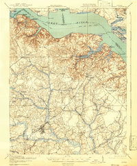
1919 Map of Surry
USGS Topo · Published 1942About this map
The James River dominates the northern reaches of this coastal Virginia landscape, where a Steamboat Route connects prominent riverside terminals like Claremont Wharf and Cobham Wharf. Inland, the economy of the early twentieth century is clearly defined by the Surry Lumber RR, which snakes through the swampy lowlands to support the region's timber industry. Major settlements including Surry and the industrial hub of Dendron serve as anchors for a dense network of rural infrastructure, including the Old Courthouse and numerous family-named landmarks like Blizzards Corners.
Find a feature on this map
86 named features on this map. Tap any name to fly to it.
Don’t see what you’re looking for? This feature index may not catch every label — zoom into the map to look around manually.
Map Details
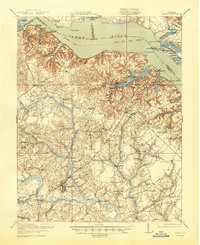
Editions of this 1919 Surry Map
3 editions found
Other maps of this area

1906 · Williamsburg
USGS Topo · 1:62,500

1907 · Yorktown
USGS Topo · 1:62,500

1917 · Toano
USGS Topo · 1:62,500

1918 · Charles City
USGS Topo · 1:62,500

1918 · Toano
USGS Topo · 1:62,500

1919 · Smithfield
USGS Topo · 1:62,500

1919 · Surry
USGS Topo · 1:62,500

1919 · Disputanta
USGS Topo · 1:62,500

1919 · Homeville
USGS Topo · 1:48,000

1920 · Ivor
USGS Topo · 1:62,500