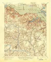
1919 Map of Surry
USGS Topo · Published 1945About this map
The James River corridor serves as the primary artery for this Tidewater landscape, with a busy Steamboat Route connecting river landings like Burdicks Wharf and Claremont Wharf. Across the water, the Jamestown National Historic Site and Colonial National Historical Park preserve the site of the first permanent English settlement, featuring Old Earthworks near Church Point.
Find a feature on this map
89 named features on this map. Tap any name to fly to it.
Don’t see what you’re looking for? This feature index may not catch every label — zoom into the map to look around manually.
Map Details
Editions of this 1919 Surry Map
3 editions found
Other maps of this area

1906 · Williamsburg
USGS Topo · 1:62,500

1907 · Yorktown
USGS Topo · 1:62,500

1917 · Toano
USGS Topo · 1:62,500

1918 · Charles City
USGS Topo · 1:62,500

1918 · Toano
USGS Topo · 1:62,500

1919 · Smithfield
USGS Topo · 1:62,500

1919 · Surry
USGS Topo · 1:62,500

1919 · Disputanta
USGS Topo · 1:62,500

1919 · Homeville
USGS Topo · 1:48,000

1920 · Ivor
USGS Topo · 1:62,500