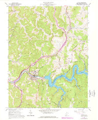
1967 Map of Sutton
USGS Topo · Published 1977About this map
The Elk River winds through the heart of Braxton County, its waters significantly altered by the presence of Sutton Lake. This survey illustrates the landscape after the construction of the dam, with the U.S. Reservation Boundary encircling the impounded waters and the nearby Elk River Public Hunting Area. The town of Sutton serves as the regional hub, situated where Granny Creek and Old Woman Run meet the river valley. The infrastructure of the mid-20th century is evident through the Baltimore and Ohio railroad corridor, which serves industrial points like Berry Siding, and the Sutton Airport located on the plateau near McNutt.
Find a feature on this map
75 named features on this map. Tap any name to fly to it.
Don’t see what you’re looking for? This feature index may not catch every label — zoom into the map to look around manually.
Map Details
Editions of this 1967 Sutton Map
2 editions found
Other maps of this area

1893 · Sutton
USGS Topo · 1:125,000

1906 · Glenville
USGS Topo · 1:62,500

1906 · Burnsville
USGS Topo · 1:62,500

1908 · Gassaway
USGS Topo · 1:48,000

1908 · Sutton
USGS Topo · 1:48,000

1910 · Sutton Special
USGS Topo · 1:62,500

1910 · Gassaway
USGS Topo · 1:62,500

1925 · Glenville
USGS Topo · 1:62,500

1925 · Burnsville
USGS Topo · 1:62,500

1927 · Burnsville
USGS Topo · 1:62,500