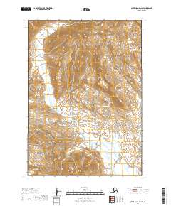
2019 Map of Sutwik Island D-4 NW
USGS Topo · Published 2019About this map
The Aleutian Range dominates this portion of the Alaska Peninsula, where steep topographic contours give way to a complex system of drainage creeks. Two major protected federal lands meet here, with the Alaska Peninsula National Wildlife Refuge covering the northern and central sections while the Aniakchak National Preserve occupies the southwest corner. The hydrology of the area is defined by the branching network of Yantarni Cr and its tributaries, including the N Fork Yantarni Cr and the aptly named Misery Cr. These watercourses flow through a landscape largely devoid of human infrastructure, reflecting the wilderness character of the region. Additional drainages like Mountain Cr and Home Cr further illustrate the rugged watershed patterns characteristic of this remote volcanic and glacial environment near the Pacific coast.
Find a feature on this map
12 named features on this map. Tap any name to fly to it.
Don’t see what you’re looking for? This feature index may not catch every label — zoom into the map to look around manually.
Map Details
Editions of this 2019 Sutwik Island D-4 NW Map
This is the sole edition of this map. No revisions or reprints were ever made.
Other maps of this area

1943 · Ugashik
USGS Topo · 1:250,000

1948 · Ugashik
USGS Topo · 1:250,000

1949 · Ugashik
USGS Topo · 1:250,000

1951 · Sutwik Island
USGS Topo · 1:250,000

1963 · Ugashik A-4
USGS Topo · 1:63,360

1963 · Sutwik Island
USGS Topo · 1:250,000
1963 · Sutwik Island D-5
USGS Topo · 1:63,360
1963 · Sutwik Island D-4
USGS Topo · 1:63,360
1963 · Ugashik A-5
USGS Topo · 1:63,360

1963 · Ugashik
USGS Topo · 1:250,000