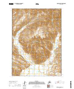
2019 Map of Sutwik Island D-5 NE
USGS Topo · Published 2019About this map
Aniakchak National Preserve dominates the central portion of this remote Alaskan terrain, where high elevations and steep contours define the wilderness character of the Alaska Peninsula. The landscape is carved by a network of drainage systems, most notably Main Cr, which meanders through the western and southern sections of the quadrangle. In the northeastern corner, the Alaska Peninsula National Wildlife Refuge provides a protected corridor for local biodiversity, while water features like Northeast Cr and Mountain Cr drain the eastern slopes toward the coast. This 2019 survey documents a region defined almost entirely by its natural hydrology and federally protected status, showing no established roads or permanent settlements in this high-latitude environment.
Find a feature on this map
9 named features on this map. Tap any name to fly to it.
Don’t see what you’re looking for? This feature index may not catch every label — zoom into the map to look around manually.
Map Details
Editions of this 2019 Sutwik Island D-5 NE Map
This is the sole edition of this map. No revisions or reprints were ever made.
Other maps of this area

1943 · Ugashik
USGS Topo · 1:250,000

1948 · Ugashik
USGS Topo · 1:250,000

1949 · Ugashik
USGS Topo · 1:250,000

1951 · Sutwik Island
USGS Topo · 1:250,000

1963 · Ugashik A-4
USGS Topo · 1:63,360

1963 · Sutwik Island
USGS Topo · 1:250,000
1963 · Sutwik Island D-5
USGS Topo · 1:63,360
1963 · Sutwik Island D-4
USGS Topo · 1:63,360
1963 · Ugashik A-5
USGS Topo · 1:63,360

1963 · Ugashik
USGS Topo · 1:250,000