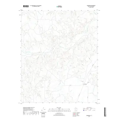
2019 Map of Swearingen
USGS Topo · Published 2019About this map
Swearingen sits in the lower southeastern corner of this Cottle County landscape, marking a concentrated point of settlement amidst a network of rural county roads. The terrain is defined by the significant hydrological paths of the N Pease River and the Middle Pease River, which carve through the northern and central sections of the quadrangle. These waterways are fed by smaller, descriptively named tributaries such as Big Nasty Cr, Little Nasty Cr, and Salt Cr. For those tracing local history, the Swearingen Cem serves as a primary genealogical landmark near the community. The map also details early transport routes and local naming conventions, including the road labeled Estirada, providing a clear look at the infrastructure connecting this part of West Texas in the late 2010s.
Find a feature on this map
11 named features on this map. Tap any name to fly to it.
Don’t see what you’re looking for? This feature index may not catch every label — zoom into the map to look around manually.
Map Details
Editions of this 2019 Swearingen Map
This is the sole edition of this map. No revisions or reprints were ever made.
Other maps of this area

1954 · Plainview
USGS Topo · 1:250,000

1958 · Plainview
USGS Topo · 1:250,000

1967 · Buckle L Ranch
USGS Topo · 1:24,000

1967 · Hell Roaring Creek
USGS Topo · 1:24,000

1967 · Kirkland South
USGS Topo · 1:24,000

1967 · Dunlap
USGS Topo · 1:24,000

1967 · Triangle Ranch
USGS Topo · 1:24,000
1967 · Baker
USGS Topo · 1:24,000

1967 · Paducah
USGS Topo · 1:24,000

1967 · Moons Camp
USGS Topo · 1:24,000