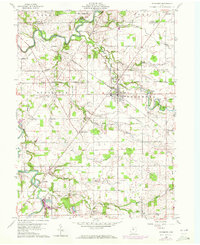
1960 Map of Sycamore
USGS Topo · Published 1972About this map
The Sandusky River meanders across this Wyandot and Seneca County landscape, defining the northern border of the village of Mexico. In the 1960s, the village of Sycamore served as a central rail junction, where the Akron Canton and Youngstown and the Penn Central railroads intersected. This mid-century survey captures a rural Ohio environment shaped by agricultural lines and historic boundary markers, most notably the Old Indian Treaty Boundary which bisects the southern townships. Smaller settlements like Belle Vernon and Deunquat are documented alongside numerous family and pioneer burial sites such as Bibler Cem and Quaker Hill Cem. The presence of several gravel pits and seasonal runs like Negro Run and Mile Run indicate the local hydrology and industrial extraction patterns typical of the era, while Camp Pittenger along the river highlights the area's recreational geography.
Find a feature on this map
42 named features on this map. Tap any name to fly to it.
Don’t see what you’re looking for? This feature index may not catch every label — zoom into the map to look around manually.
Map Details
Editions of this 1960 Sycamore Map
Other maps of this area

1901 · Fostoria
USGS Topo · 1:62,500

1903 · Fostoria
USGS Topo · 1:62,500

1906 · Sycamore
USGS Topo · 1:62,500

1906 · Tiffin
USGS Topo · 1:62,500

1907 · Upper Sandusky
USGS Topo · 1:62,500

1950 · Marion
USGS Topo · 1:250,000

1956 · Toledo
USGS Topo · 1:250,000

1960 · Sycamore
USGS Topo · 1:24,000

1960 · Tiffin South
USGS Topo · 1:24,000

1960 · Oceola
USGS Topo · 1:24,000