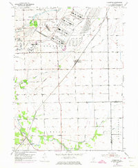
1953 Map of Symerton
USGS Topo · Published 1974About this map
The Joliet Arsenal dominates the northern landscape of this mid-century survey, its expansive industrial and military footprint defined by the Government Railroad. This facility contrasts with the surrounding agricultural townships of Florence and Wesley, where rural life is anchored by landmarks like the Bell Sch and the Star Grove Cem. The settlement of Symerton sits at the heart of the quadrangle, while to the south, the communities of Ritchie and Ritchie Sta follow the path of Forked Creek. Transportation is a key theme, tracing the transition from the Old Norfolk and Western rail corridor to the emerging network of modern infrastructure represented by the purple-coded Pipeline revisions. Genealogists will find value in the specific locations of the Chicago Road Cem and local schoolhouses that served these tight-knit farming communities.
Find a feature on this map
21 named features on this map. Tap any name to fly to it.
Don’t see what you’re looking for? This feature index may not catch every label — zoom into the map to look around manually.
Map Details
Editions of this 1953 Symerton Map
2 editions found

Other maps of this area

1892 · Wilmington
USGS Topo · 1:62,500

1918 · Wilmington
USGS Topo · 1:62,500

1922 · Kankakee
USGS Topo · 1:62,500

1923 · Herscher
USGS Topo · 1:62,500

1924 · Kankakee
USGS Topo · 1:62,500

1925 · Herscher
USGS Topo · 1:62,500

1929 · Brisbane
USGS Topo · 1:24,000

1949 · Peotone
USGS Topo · 1:62,500
1953 · Manhattan
USGS Topo · 1:24,000

1953 · Wilton Center
USGS Topo · 1:24,000