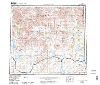
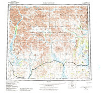
1956 Map of Table Mountain
USGS Topo · Published 1984About this map
The Brooks Range dominates this landscape, where the Continental Divide separates the northward flow of the Kongakut River from the expansive southern watersheds of the Sheenjek River and Coleen River. This mid-century survey documents a vast wilderness prior to modern intensification, marked only by a solitary Cabin in the northeast and a sparse network of natural landmarks. Notable elevations include Table Mtn, Kaultui Mtn, and Ammerman Mountain. The map illustrates the headwaters of the Firth River and Old Crow River as they cross the United States Canada international boundary. To the south, the East Fork Sheenjek River and Bilwaddy Creek carve through the foothills, providing critical drainage for the Arctic National Wildlife Refuge. This data reflects a time when the region remained one of the most isolated stretches of the American frontier, primarily serving as a sanctuary for wildlife and a site for specialized geodetic research.
Find a feature on this map
36 named features on this map. Tap any name to fly to it.
Don’t see what you’re looking for? This feature index may not catch every label — zoom into the map to look around manually.
Map Details
Editions of this 1956 Table Mountain Map
6 editions found
Other maps of this area

1951 · Demarcation Point
USGS Topo · 1:250,000

1951 · Coleen
USGS Topo · 1:250,000

1951 · Christian
USGS Topo · 1:250,000

1951 · Arctic
USGS Topo · 1:250,000

1951 · Table Mountain
USGS Topo · 1:250,000

1951 · Mt. Michelson
USGS Topo · 1:250,000

1955 · Demarcation Point
USGS Topo · 1:250,000

1956 · Table Mountain
USGS Topo · 1:250,000

1956 · Coleen
USGS Topo · 1:250,000

1956 · Arctic
USGS Topo · 1:250,000