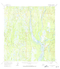
1958 Map of Talkeetna B-1
USGS Topo · Published 1974About this map
Talkeetna River, Chulitna River, and Susitna River converge in a massive braided waterway system that dominates this 1958 interior Alaska landscape. The settlement of Talkeetna serves as the focal point for transportation, featuring a Landing Strip, multiple Towers, and the The Alaska Railroad line running north through Chase. The mapping reveals a transition from the river lowlands to the rising elevations of the Talkeetna Hills and Bartlett Hills to the east. Local history and utility are noted through features like the Bartlett Earth Station and several remote cabins scattered along the drainages of Whiskers Creek and Trapper Creek. Numerous named lakes, including Sawmill Lake and Christianen Lake, highlight the water-rich terrain of the Susitna Borough before modern highway expansion altered local access patterns.
Find a feature on this map
36 named features on this map. Tap any name to fly to it.
Don’t see what you’re looking for? This feature index may not catch every label — zoom into the map to look around manually.
Map Details
Editions of this 1958 Talkeetna B-1 Map
4 editions found

Other maps of this area

1949 · Talkeetna Mountains B-6
USGS Topo · 1:63,360

1949 · Talkeetna Mountains C-6
USGS Topo · 1:63,360

1950 · Talkeetna Mountains
USGS Topo · 1:250,000

1950 · Talkeetna
USGS Topo · 1:250,000

1950 · Talkeetna Mountains A-6
USGS Topo · 1:63,360

1951 · Talkeetna
USGS Topo · 1:250,000

1951 · Talkeetna B-1
USGS Topo · 1:63,360

1951 · Talkeetna C-1
USGS Topo · 1:63,360

1952 · Talkeetna Mountains C-6
USGS Topo · 1:63,360

1952 · Talkeetna Mountains B-6
USGS Topo · 1:63,360