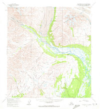
1958 Map of Talkeetna C-2
USGS Topo · Published 1972About this map
The Tokosha Mountains dominate the northern landscape of this interior Alaska region, marking a massive glacial environment where the Kanikula Glacier, Tokositna Glacier, and Ruth Glacier carve deep into the terrain. Below these frozen heights, the Tokositna River winds through a valley flanked by the Dutch Hills and Peters Hills. This 1950s survey captures an era of active resource extraction and remote access, evidenced by a placer mine near Bird Creek and several landing strips that served as vital links to the outside world. Numerous gulches such as Ramsdyke Gulch, Wonder Gulch, and Dandy Gulch hint at the prospecting history of the area. A network of trails and tractor trails connect these operations to water sources like Peters Creek and Cache Creek, illustrating the logistical challenges of subarctic mining.
Find a feature on this map
43 named features on this map. Tap any name to fly to it.
Don’t see what you’re looking for? This feature index may not catch every label — zoom into the map to look around manually.
Map Details
Editions of this 1958 Talkeetna C-2 Map
5 editions found
Other maps of this area

1950 · Talkeetna
USGS Topo · 1:250,000

1951 · Talkeetna
USGS Topo · 1:250,000

1951 · Talkeetna B-1
USGS Topo · 1:63,360

1951 · Talkeetna C-1
USGS Topo · 1:63,360

1954 · Talkeetna B-3
USGS Topo · 1:63,360

1954 · Talkeetna B-2
USGS Topo · 1:63,360

1958 · Talkeetna B-1
USGS Topo · 1:63,360

1958 · Talkeetna C-1
USGS Topo · 1:63,360

1958 · Talkeetna C-2
USGS Topo · 1:63,360

1958 · Talkeetna D-2
USGS Topo · 1:63,360