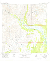
1958 Map of Talkeetna C-2
USGS Topo · Published 1978About this map
Tokositna River and its braided channels form the central artery of this interior landscape, where glacial runoff from the Tokositna Glacier and Kanikula Glacier feeds the valley floor. Evidence of mid-century exploration and resource extraction is scattered throughout the Dutch Hills and Peters Hills, where several Placer Mines are located along drainages like Bird Creek and Lucky Gulch. These operations were supported by a network of Tractor Trails and a remote Landing Strip near Peters Creek. The map also captures the vast icy reaches of the Ruth Glacier in the northeast corner and prominent summits like Mount Goldie. Isolated Cabin labels suggest the presence of seasonal dwellings or mining camps in this terrain, located far from established towns.
Find a feature on this map
46 named features on this map. Tap any name to fly to it.
Don’t see what you’re looking for? This feature index may not catch every label — zoom into the map to look around manually.
Map Details
Editions of this 1958 Talkeetna C-2 Map
5 editions found
Other maps of this area

1950 · Talkeetna
USGS Topo · 1:250,000

1951 · Talkeetna
USGS Topo · 1:250,000

1951 · Talkeetna B-1
USGS Topo · 1:63,360

1951 · Talkeetna C-1
USGS Topo · 1:63,360

1954 · Talkeetna B-3
USGS Topo · 1:63,360

1954 · Talkeetna B-2
USGS Topo · 1:63,360

1958 · Talkeetna B-1
USGS Topo · 1:63,360

1958 · Talkeetna C-1
USGS Topo · 1:63,360

1958 · Talkeetna C-2
USGS Topo · 1:63,360

1958 · Talkeetna D-2
USGS Topo · 1:63,360