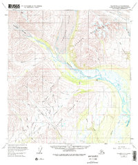
1958 Map of Talkeetna C-2
USGS Topo · Published 1978About this map
Ruth Glacier and the massive ice flows of Kanikula Glacier and Tokositna Glacier dominate this remote Alaskan landscape, carving deep valleys between the Tokosha Mountains and the Dutch Hills. Below the glacial terminuses, the Tokositna River braids through wide gravel flats, joined by numerous drainages such as Wildhorse Creek and Canyon Creek. The presence of a Placer Mine near Cache Creek and another along the Tractor Trail highlights the mid-century mineral exploration in the region. Evidence of small-scale aviation and seasonal habitation is found at the Landing Strip and isolated Cabin sites. This 1950s survey reflects a period when access to these high-latitude valleys relied heavily on rough trails and river corridors, with labels like Lucky Gulch and Ruby Gulch pointing to a legacy of prospecting and resource extraction in the Peters Hills.
Find a feature on this map
46 named features on this map. Tap any name to fly to it.
Don’t see what you’re looking for? This feature index may not catch every label — zoom into the map to look around manually.
Map Details
Editions of this 1958 Talkeetna C-2 Map
5 editions found
Other maps of this area

1950 · Talkeetna
USGS Topo · 1:250,000

1951 · Talkeetna
USGS Topo · 1:250,000

1951 · Talkeetna B-1
USGS Topo · 1:63,360

1951 · Talkeetna C-1
USGS Topo · 1:63,360

1954 · Talkeetna B-3
USGS Topo · 1:63,360

1954 · Talkeetna B-2
USGS Topo · 1:63,360

1958 · Talkeetna B-1
USGS Topo · 1:63,360

1958 · Talkeetna C-1
USGS Topo · 1:63,360

1958 · Talkeetna C-2
USGS Topo · 1:63,360

1958 · Talkeetna D-2
USGS Topo · 1:63,360