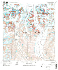
1958 Map of Talkeetna D-2
USGS Topo · Published 1975About this map
Denali National Park encompasses this high-altitude landscape, where massive glacial systems define the topography of the Alaska Range. The survey, based on 1952 aerial photography and 1958 field annotations, captures a vertical world dominated by the massive Ruth Glacier and the sheer walls of The Great Gorge. Peaks such as Mount Huntington, The Mooses Tooth, and Mount Dickey tower over the Ruth Amphitheater, illustrating the extreme glacial carving that shaped this region. To the east and west, the Buckskin Glacier and Tokositna Glacier highlight the interconnected nature of these ice flows before they descend into lower drainage basins like Alder Creek. This map is a record of the park's glaciology and high-peaks geography mid-century, long before modern climatic shifts altered these massive ice sheets.
Find a feature on this map
23 named features on this map. Tap any name to fly to it.
Don’t see what you’re looking for? This feature index may not catch every label — zoom into the map to look around manually.
Map Details
Editions of this 1958 Talkeetna D-2 Map
3 editions found
Other maps of this area

1950 · Talkeetna
USGS Topo · 1:250,000

1951 · Talkeetna
USGS Topo · 1:250,000

1951 · Talkeetna C-1
USGS Topo · 1:63,360

1952 · Mount McKinley
USGS Topo · 1:250,000

1954 · Mount McKinley A-2
USGS Topo · 1:63,360

1954 · Mount McKinley A-3
USGS Topo · 1:63,360

1954 · Mount McKinley A-1
USGS Topo · 1:63,360

1958 · Talkeetna C-1
USGS Topo · 1:63,360

1958 · Talkeetna C-2
USGS Topo · 1:63,360

1958 · Talkeetna D-2
USGS Topo · 1:63,360