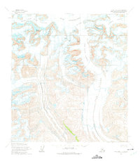
1958 Map of Talkeetna D-2
USGS Topo · Published 1975About this map
Ruth Glacier and the massive Tokositna Glacier dominate this mid-century survey of the Alaska Range within the Matanuska-Susitna Borough. The landscape is defined by its vertical extremes, featuring prominent peaks such as Mount Huntington, The Mooses Tooth, and Mount Dickey. A collaborative effort between the U.S. Geological Survey and the Museum of Science in Boston, the map provides a high-resolution view of the area's complex glacial system, including the expansive Ruth Amphitheater and the dramatic narrow passage known as The Great Gorge. While the higher elevations are locked in ice, the lower reaches in the southeast show the headwaters of Whistler Creek and Alder Creek, illustrating the transition from alpine ice fields to the developing drainage patterns of the Alaskan interior during the 1950s.
Find a feature on this map
17 named features on this map. Tap any name to fly to it.
Don’t see what you’re looking for? This feature index may not catch every label — zoom into the map to look around manually.
Map Details
Editions of this 1958 Talkeetna D-2 Map
3 editions found
Other maps of this area

1950 · Talkeetna
USGS Topo · 1:250,000

1951 · Talkeetna
USGS Topo · 1:250,000

1951 · Talkeetna C-1
USGS Topo · 1:63,360

1952 · Mount McKinley
USGS Topo · 1:250,000

1954 · Mount McKinley A-2
USGS Topo · 1:63,360

1954 · Mount McKinley A-3
USGS Topo · 1:63,360

1954 · Mount McKinley A-1
USGS Topo · 1:63,360

1958 · Talkeetna C-1
USGS Topo · 1:63,360

1958 · Talkeetna C-2
USGS Topo · 1:63,360

1958 · Talkeetna D-2
USGS Topo · 1:63,360