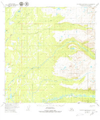
1950 Map of Talkeetna Mountains A-6
USGS Topo · Published 1980About this map
The Talkeetna Mountains rise sharply in this 1950s-era study, where high-altitude survey markers like Vabm 4559 Snowshoe and Vabm 4157 Wolverine define the peaks of the Alaskan interior. The landscape is dominated by a complex network of glacial meltwater and mountain streams, most notably the meandering Kashwitna River and the North Fork Kashwitna River. These waterways, along with Sheep Creek and Montana Creek, create a distinct drainage pattern characteristic of the region before significant modern development. Numerous smaller water bodies such as Caswell Lake and Benka Lake are scattered across the lower elevations. The absence of roads or established settlements on this sheet highlights the wilderness character of the Matanuska-Susitna Borough at mid-century, preserving a record of the terrain as it was navigated by early surveyors and aerial photographers.
Find a feature on this map
22 named features on this map. Tap any name to fly to it.
Don’t see what you’re looking for? This feature index may not catch every label — zoom into the map to look around manually.
Map Details
Editions of this 1950 Talkeetna Mountains A-6 Map
4 editions found
Other maps of this area

1949 · Tyonek
USGS Topo · 1:250,000

1949 · Anchorage D-7
USGS Topo · 1:63,360

1949 · Talkeetna Mountains B-6
USGS Topo · 1:63,360

1949 · Anchorage D-8
USGS Topo · 1:63,360

1950 · Talkeetna Mountains
USGS Topo · 1:250,000

1950 · Talkeetna
USGS Topo · 1:250,000

1950 · Talkeetna Mountains B-5
USGS Topo · 1:63,360

1950 · Talkeetna Mountains A-6
USGS Topo · 1:63,360

1950 · Talkeetna Mountains A-5
USGS Topo · 1:63,360

1951 · Talkeetna
USGS Topo · 1:250,000