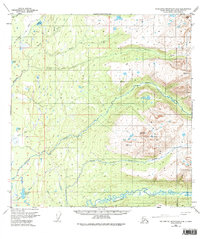
1950 Map of Talkeetna Mountains A-6
USGS Topo · Published 1984About this map
The Sheep Mountains dominate the eastern landscape of this interior Alaska region, rising sharply above a complex network of glacial meltwater streams. In the mid-twentieth century, as aerial photography from 1949 began to replace older ground surveys, the intricate drainage patterns of the Kashwitna River and the North Fork Kashwitna River were documented with new precision. The terrain is defined by a series of significant creeks including Montana Creek, Sheep Creek, and Goose Creek, which carve through the valley floor. Several remote water bodies, such as Caswell Lake, Benka Lake, and Emil Lake, dot the lowlands, while survey points like VABM Wolverine 4157 and VABM Snowshoe 4559 mark the high peaks. This 1950 data provides a foundational view of the Matanuska-Susitna Borough before modern infrastructure altered the subarctic wilderness.
Find a feature on this map
21 named features on this map. Tap any name to fly to it.
Don’t see what you’re looking for? This feature index may not catch every label — zoom into the map to look around manually.
Map Details
Editions of this 1950 Talkeetna Mountains A-6 Map
4 editions found
Other maps of this area

1949 · Tyonek
USGS Topo · 1:250,000

1949 · Anchorage D-7
USGS Topo · 1:63,360

1949 · Talkeetna Mountains B-6
USGS Topo · 1:63,360

1949 · Anchorage D-8
USGS Topo · 1:63,360

1950 · Talkeetna Mountains
USGS Topo · 1:250,000

1950 · Talkeetna
USGS Topo · 1:250,000

1950 · Talkeetna Mountains B-5
USGS Topo · 1:63,360

1950 · Talkeetna Mountains A-6
USGS Topo · 1:63,360

1950 · Talkeetna Mountains A-5
USGS Topo · 1:63,360

1951 · Talkeetna
USGS Topo · 1:250,000