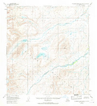
1951 Map of Talkeetna Mountains B-2
USGS Topo · Published 1971About this map
Talkeetna Mountains terrain dominates this mid-century topographic study, defined by a complex network of glacial-fed drainages and high-altitude basins. The hydrology of the region is anchored by the Oshetna River and the Black River, which carve through the high country alongside the Little Oshetna River. Significant bodies of water such as Crater Lake and Black Lake are prominent features within these uplands, serving as landmarks in a landscape otherwise devoid of roads or established settlements. The 1951 field annotations also document several smaller watercourses, including Granite Creek, Roaring Creek, and Gold Creek, which descend from the slopes of the Twin Hills. This survey provides an essential view of the interior Alaskan wilderness before modern development, capturing the drainage patterns and landforms of the Seward Meridian as they were documented shortly after World War II.
Find a feature on this map
12 named features on this map. Tap any name to fly to it.
Don’t see what you’re looking for? This feature index may not catch every label — zoom into the map to look around manually.
Map Details
Editions of this 1951 Talkeetna Mountains B-2 Map
3 editions found
Other maps of this area

1949 · Talkeetna Mountains A-1
USGS Topo · 1:63,360

1950 · Talkeetna Mountains
USGS Topo · 1:250,000

1951 · Talkeetna Mountains B-1
USGS Topo · 1:63,360

1951 · Talkeetna Mountains A-2
USGS Topo · 1:63,360

1951 · Talkeetna Mountains C-2
USGS Topo · 1:63,360

1951 · Talkeetna Mountains B-3
USGS Topo · 1:63,360

1951 · Talkeetna Mountains A-3
USGS Topo · 1:63,360

1951 · Talkeetna Mountains B-2
USGS Topo · 1:63,360

1951 · Talkeetna Mountains C-1
USGS Topo · 1:63,360

1951 · Talkeetna Mountains C-3
USGS Topo · 1:63,360