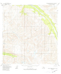
1950 Map of Talkeetna Mountains B-4
USGS Topo · Published 1977About this map
The Talkeetna River flows through the northeastern corner of this terrain, marking a significant drainage path within the Talkeetna Mountains. The landscape is defined by its complex hydrology, with Iron Creek and its major tributaries, the East Fork and Middle Fork, carving through the high elevations. This mid-century survey, based on aerial photography from 1949 and 1957, reveals a wilderness devoid of roads or trails, where geographic orientation relied entirely on natural landmarks and triangulation stations. Numerous vertical angle bench marks, including Vabm 9917 Atala, Vabm 6459 Remus, and Vabm 6466 Sedan, provide specific geodetic control points across the peaks. To the southeast, Yellowjacket Creek adds to the network of watercourses that shaped the navigational challenges for early surveyors and explorers in this part of the Matanuska-Susitna region.
Find a feature on this map
12 named features on this map. Tap any name to fly to it.
Don’t see what you’re looking for? This feature index may not catch every label — zoom into the map to look around manually.
Map Details
Editions of this 1950 Talkeetna Mountains B-4 Map
3 editions found
Other maps of this area

1949 · Talkeetna Mountains A-4
USGS Topo · 1:63,360

1950 · Talkeetna Mountains
USGS Topo · 1:250,000

1950 · Talkeetna Mountains B-5
USGS Topo · 1:63,360

1950 · Talkeetna Mountains B-4
USGS Topo · 1:63,360

1950 · Talkeetna Mountains A-5
USGS Topo · 1:63,360

1950 · Talkeetna Mountains C-5
USGS Topo · 1:63,360

1951 · Talkeetna Mountains B-3
USGS Topo · 1:63,360

1951 · Talkeetna Mountains A-3
USGS Topo · 1:63,360

1951 · Talkeetna Mountains C-4
USGS Topo · 1:63,360

1951 · Talkeetna Mountains C-3
USGS Topo · 1:63,360