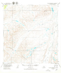
1951 Map of Talkeetna Mountains C-3
USGS Topo · Published 1980About this map
Mt Watana rises as a prominent landmark in this mid-century survey of the Talkeetna Mountains, overlooking a landscape defined by an intricate drainage network. Based on 1949 aerial photography, the map reveals a remote subarctic environment where Watana Lake feeds into a system of named waterways including Fog Creek and Tsisi Creek. The topography is marked by the distinctive Tsisi Terrace, a geological benching that contrasts with the steep elevations of the surrounding peaks. This map captures the region before extensive modern infrastructure, with large portions marked as unsurveyed and predetermined by the Bureau of Land Management. The presence of southern drainages like Kosina Creek, John Creek, and George Creek suggests the seasonal routes and natural corridors used by early travelers and surveyors through this Alaskan interior.
Find a feature on this map
9 named features on this map. Tap any name to fly to it.
Don’t see what you’re looking for? This feature index may not catch every label — zoom into the map to look around manually.
Map Details
Editions of this 1951 Talkeetna Mountains C-3 Map
3 editions found
Other maps of this area

1950 · Talkeetna Mountains
USGS Topo · 1:250,000

1950 · Talkeetna Mountains B-4
USGS Topo · 1:63,360

1951 · Talkeetna Mountains C-2
USGS Topo · 1:63,360

1951 · Talkeetna Mountains B-3
USGS Topo · 1:63,360

1951 · Talkeetna Mountains D-2
USGS Topo · 1:63,360

1951 · Talkeetna Mountains B-2
USGS Topo · 1:63,360

1951 · Talkeetna Mountains C-4
USGS Topo · 1:63,360

1951 · Talkeetna Mountains D-3
USGS Topo · 1:63,360

1951 · Talkeetna Mountains D-4
USGS Topo · 1:63,360

1951 · Talkeetna Mountains C-3
USGS Topo · 1:63,360