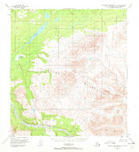
1951 Map of Talkeetna Mountains C-4
USGS Topo · Published 1972About this map
Talkeetna Mountains dominate this 1:63,360 scale survey, which illustrates the high-elevation terrain of Southcentral Alaska as it was recorded shortly after mid-century. The Talkeetna River flows through the southern portion of the quadrangle, serving as a primary drainage for the massive peaks that occupy the central and eastern sections. To the northwest, the topography transitions into a basin characterized by significant water bodies, most notably the large, irregular Stephan Lake and the smaller Daneka Lake.
Find a feature on this map
5 named features on this map. Tap any name to fly to it.
Don’t see what you’re looking for? This feature index may not catch every label — zoom into the map to look around manually.
Map Details
Editions of this 1951 Talkeetna Mountains C-4 Map
3 editions found
Other maps of this area

1950 · Talkeetna Mountains
USGS Topo · 1:250,000

1950 · Talkeetna Mountains B-5
USGS Topo · 1:63,360

1950 · Talkeetna Mountains B-4
USGS Topo · 1:63,360

1950 · Talkeetna Mountains D-5
USGS Topo · 1:63,360

1950 · Talkeetna Mountains C-5
USGS Topo · 1:63,360

1951 · Talkeetna Mountains D-5
USGS Topo · 1:63,360

1951 · Talkeetna Mountains B-3
USGS Topo · 1:63,360

1951 · Talkeetna Mountains C-4
USGS Topo · 1:63,360

1951 · Talkeetna Mountains D-3
USGS Topo · 1:63,360

1951 · Talkeetna Mountains D-4
USGS Topo · 1:63,360