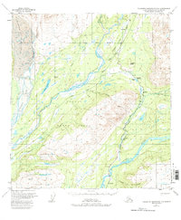
1951 Map of Talkeetna Mountains D-6
USGS Topo · Published 1983About this map
The The Alaska Railroad serves as the primary artery through this wilderness corridor, following the narrow valleys carved by the Susitna River and Chulitna River. Published in the early 1950s, the map reveals a series of critical railroad mileposts and small settlements such as Hurricane, Canyon, and Gold Creek, which historically functioned as essential stops and maintenance points along the rail line. The terrain is dominated by the massive Eldridge Glacier in the northwest and the protected lands of Denali State Park.
Find a feature on this map
40 named features on this map. Tap any name to fly to it.
Don’t see what you’re looking for? This feature index may not catch every label — zoom into the map to look around manually.
Map Details
Editions of this 1951 Talkeetna Mountains D-6 Map
4 editions found

Other maps of this area

1949 · Talkeetna Mountains D-6
USGS Topo · 1:63,360

1949 · Talkeetna Mountains C-6
USGS Topo · 1:63,360

1949 · Healy A-6
USGS Topo · 1:63,360

1950 · Talkeetna Mountains
USGS Topo · 1:250,000

1950 · Talkeetna
USGS Topo · 1:250,000

1950 · Talkeetna Mountains D-5
USGS Topo · 1:63,360

1950 · Healy A-5
USGS Topo · 1:63,360

1950 · Talkeetna Mountains C-5
USGS Topo · 1:63,360

1951 · Talkeetna
USGS Topo · 1:250,000

1951 · Healy
USGS Topo · 1:250,000