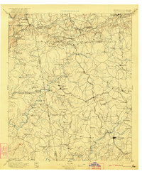
1897 Map of Tallapoosa
USGS Topo · Published 1922About this map
Tallapoosa and Bremen anchor this industrial and agricultural corridor at the turn of the century, where the Southern Railway and the Chattanooga Rome and Columbus Railroad intersect the winding path of the Tallapoosa River. The landscape is a network of water-powered industry, documented by numerous family mills such as Munroe Mill, Hightower Mill, and Allgoods Mill. This survey, conducted by Louis Nell and M. Hackett, captures the Georgia-Alabama borderlands during a period of mining and timber development. Numerous settlements like Fruithurst and Waco appear alongside mountain landmarks including Dugdown Mountain and Black Jack Mt.. Local social centers are noted at Pinewood Church and Shiloh, while various river crossings such as McBride Bridge and Rainwater Ford indicate the era's primary travel routes before modern highways dominated the region.
Find a feature on this map
141 named features on this map. Tap any name to fly to it.
Don’t see what you’re looking for? This feature index may not catch every label — zoom into the map to look around manually.
Map Details
Editions of this 1897 Tallapoosa Map
4 editions found

Other maps of this area

1886 · Rome
USGS Topo · 1:125,000

1889 · Tallapoosa
USGS Topo · 1:125,000

1890 · Cartersville
USGS Topo · 1:125,000

1891 · Marietta
USGS Topo · 1:125,000

1891 · Cartersville
USGS Topo · 1:125,000

1891 · Ashland
USGS Topo · 1:125,000

1892 · Tallapoosa
USGS Topo · 1:125,000

1893 · Fort Payne
USGS Topo · 1:125,000

1895 · Marietta
USGS Topo · 1:125,000

1896 · Cartersville
USGS Topo · 1:125,000