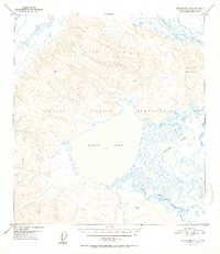
1952 Map of Tanacross A-4
USGS Topo · Published 1952About this map
The Tetlin Indian Reservation dominates this 1948 aerial survey of the Alaska interior, centering on the massive Tetlin Lake. This vast drainage system is defined by the winding paths of the Tok River and the Tanana River to the north, which carve through the Tetlin Hills. The landscape is a complex network of wetlands and smaller water bodies, including the Gasoline Lakes and the Tetlin River, showing the seasonal hydrology of the Fourth Judicial Division before modern development. Evidence of human presence is concentrated around the Airstrip Tetlin and scattered Cabins along the water's edge, highlighting the reliance on bush aviation and river travel. Significant high points such as Chisana Mountain provide navigational landmarks in a region defined by its shifting braided rivers and marshlands.
Find a feature on this map
16 named features on this map. Tap any name to fly to it.
Don’t see what you’re looking for? This feature index may not catch every label — zoom into the map to look around manually.
Map Details
Editions of this 1952 Tanacross A-4 Map
2 editions found

Other maps of this area

1948 · Tanacross B-5
USGS Topo · 1:63,360

1948 · Tanacross A-3
USGS Topo · 1:63,360

1948 · Tanacross A-4
USGS Topo · 1:63,360

1948 · Nabesna D-5
USGS Topo · 1:63,360

1948 · Tanacross A-5
USGS Topo · 1:63,360

1948 · Tanacross B-3
USGS Topo · 1:63,360

1949 · Tanacross
USGS Topo · 1:250,000

1949 · Tanacross B-4
USGS Topo · 1:63,360

1949 · Tanacross A-5
USGS Topo · 1:63,360

1949 · Tanacross B-3
USGS Topo · 1:63,360