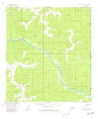
1956 Map of Tanacross B-1
USGS Topo · Published 1980About this map
The Alaska Yukon international boundary defines the eastern edge of this 1950s survey, where the Ladue River meanders through an expansive system of wetlands and low-relief terrain. This remote interior landscape is characterized by its drainage network, with Chicken Creek and Deep Cr feeding into the primary river system. A single Cabin near the center of the sheet serves as a rare indicator of human presence in a territory otherwise dominated by natural features and survey markers. High points such as Vabm 4181 Summit and Vabm 3578 Oh Ti provide topographic context for the surrounding marshes and creek beds. The map reflects a period of surveying where land lines were predetermined by the Bureau of Land Management but remained largely unsurveyed and unmarked on the ground, illustrating the vast, undeveloped character of the United States Canada borderlands at mid-century.
Find a feature on this map
9 named features on this map. Tap any name to fly to it.
Don’t see what you’re looking for? This feature index may not catch every label — zoom into the map to look around manually.
Map Details
Editions of this 1956 Tanacross B-1 Map
2 editions found
Other maps of this area

1949 · Tanacross
USGS Topo · 1:250,000

1950 · Tanacross
USGS Topo · 1:250,000

1952 · Tanacross A-1
USGS Topo · 1:63,360

1954 · Tanacross A-2
USGS Topo · 1:63,360

1955 · Tanacross A-2
USGS Topo · 1:63,360

1956 · Tanacross C-1
USGS Topo · 1:63,360
1956 · Tanacross B-1
USGS Topo · 1:63,360

1956 · Tanacross C-2
USGS Topo · 1:63,360
1956 · Tanacross B-2
USGS Topo · 1:63,360

1956 · Tanacross
USGS Topo · 1:250,000