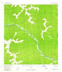
1956 Map of Tanacross B-1
USGS Topo · Published 1962About this map
The Ladue River meanders through this portion of the Alaska-Yukon boundary, its complex oxbows and wetlands dominating the central valley. This mid-1950s survey captures a wilderness landscape largely devoid of permanent development, save for a solitary Cabin situated near the riverbank. Surveyed via photogrammetric methods between 1952 and 1955, the terrain is defined by significant elevations such as VABM 4181 Summit and VABM 3518 Oh-Ti, which served as critical triangulation points for the Geological Survey. Small waterways including Chicken Creek, McArthur, and Deep drain the surrounding uplands toward the international border. The mapping of this frontier area reflects the Cold War era's logistical focus on precise border demarcation and geographic data collection in the most inaccessible reaches of the Territory of Alaska.
Find a feature on this map
9 named features on this map. Tap any name to fly to it.
Don’t see what you’re looking for? This feature index may not catch every label — zoom into the map to look around manually.
Map Details
Editions of this 1956 Tanacross B-1 Map
2 editions found
Other maps of this area

1949 · Tanacross
USGS Topo · 1:250,000

1950 · Tanacross
USGS Topo · 1:250,000

1952 · Tanacross A-1
USGS Topo · 1:63,360

1954 · Tanacross A-2
USGS Topo · 1:63,360

1955 · Tanacross A-2
USGS Topo · 1:63,360

1956 · Tanacross C-1
USGS Topo · 1:63,360

1956 · Tanacross C-2
USGS Topo · 1:63,360
1956 · Tanacross B-2
USGS Topo · 1:63,360

1956 · Tanacross
USGS Topo · 1:250,000

1964 · Tanacross
USGS Topo · 1:250,000