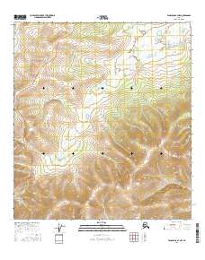
2016 Map of Tanacross B-3 NW
USGS Topo · Published 2016About this map
The Dennison Fork carves a winding path through this corner of the Southeast Fairbanks region, serving as the primary hydrologic feature in a landscape defined by sharp elevation shifts and intricate drainage patterns. In the western portion of the quadrangle, the Taylor Highway navigates the ridgelines, providing a critical terrestrial corridor through the interior. This topographic study illuminates the spatial relationship between the high-altitude road system and the lower riparian environment of the river fork below. The map also delineates several township and range boundaries, including T19n R15e and T20n R16e, which organize the vast tracts of land. Researchers can observe the interplay between modern transportation infrastructure and the natural contours of the Alaskan interior in the years following the turn of the millennium.
Find a feature on this map
8 named features on this map. Tap any name to fly to it.
Don’t see what you’re looking for? This feature index may not catch every label — zoom into the map to look around manually.
Map Details
Editions of this 2016 Tanacross B-3 NW Map
This is the sole edition of this map. No revisions or reprints were ever made.
Other maps of this area

1948 · Tanacross B-3
USGS Topo · 1:63,360

1949 · Tanacross
USGS Topo · 1:250,000

1949 · Tanacross B-4
USGS Topo · 1:63,360

1949 · Tanacross B-3
USGS Topo · 1:63,360

1950 · Tanacross
USGS Topo · 1:250,000

1951 · Tanacross B-4
USGS Topo · 1:63,360

1952 · Tanacross B-3
USGS Topo · 1:63,360

1956 · Tanacross C-3
USGS Topo · 1:63,360
1956 · Tanacross C-4
USGS Topo · 1:63,360

1956 · Tanacross
USGS Topo · 1:250,000