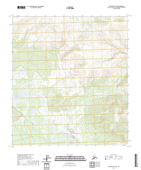
2024 Map of Tanacross B-4 NW
USGS Topo · Published 2024About this map
The Tanana River dominates the landscape of this Interior Alaska region, its complex braided channels and expansive wetlands cutting a wide path through the southern half of the quadrangle. On the northern banks of a major river bend, the community of Tok serves as a critical junction point where the valley floor meets the rising upland terrain to the north. The map details the transition from the low-lying river basin into the high ridges and steep contours of the surrounding hills, illustrating the geographic constraints that have influenced settlement patterns and transportation routes in the Southeast Fairbanks area. Beyond the immediate vicinity of the river and the settlement, the terrain is characterized by a dense network of survey townships, including t20n r13e and t19n r13e, which organize the vast, largely undeveloped wilderness surrounding this Alaskan crossroads.
Find a feature on this map
7 named features on this map. Tap any name to fly to it.
Don’t see what you’re looking for? This feature index may not catch every label — zoom into the map to look around manually.
Map Details
Editions of this 2024 Tanacross B-4 NW Map
This is the sole edition of this map. No revisions or reprints were ever made.
Other maps of this area

1948 · Tanacross B-5
USGS Topo · 1:63,360

1949 · Tanacross
USGS Topo · 1:250,000

1949 · Tanacross B-4
USGS Topo · 1:63,360

1950 · Tanacross
USGS Topo · 1:250,000

1951 · Tanacross B-4
USGS Topo · 1:63,360

1952 · Tanacross B-5
USGS Topo · 1:63,360
1956 · Tanacross C-5
USGS Topo · 1:63,360
1956 · Tanacross C-4
USGS Topo · 1:63,360

1956 · Tanacross
USGS Topo · 1:250,000

1964 · Tanacross
USGS Topo · 1:250,000