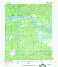
1952 Map of Tanana A-6
USGS Topo · Published 1971About this map
The Yukon River carves through this Interior Alaska landscape, flanked by a network of complex waterways and seasonal transportation routes recorded in the early 1950s. Near the confluence of Gold Hill Creek and the main channel, the Indian Village stands with its associated Cem, serving as a focal point for settlement along the riverbank. The map documents a rugged reliance on seasonal movement, featuring a Sled Road winding through Gold Hill and various Tractor Trails connecting isolated Cabins.
Find a feature on this map
37 named features on this map. Tap any name to fly to it.
Don’t see what you’re looking for? This feature index may not catch every label — zoom into the map to look around manually.
Map Details
Editions of this 1952 Tanana A-6 Map
3 editions found
Other maps of this area

1948 · Kantishna River
USGS Topo · 1:250,000

1951 · Kantishna River
USGS Topo · 1:250,000

1951 · Ruby
USGS Topo · 1:250,000

1951 · Melozitna
USGS Topo · 1:250,000

1951 · Tanana
USGS Topo · 1:250,000

1952 · Kantishna River D-5
USGS Topo · 1:63,360

1952 · Ruby D-1
USGS Topo · 1:63,360

1952 · Kantishna River
USGS Topo · 1:250,000

1952 · Tanana A-6
USGS Topo · 1:63,360

1952 · Kantishna River D-6
USGS Topo · 1:63,360