
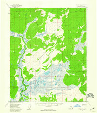
1956 Map of Tanana D-6
USGS Topo · Published 1978About this map
The Tanana-Allakaket Winter Trail cuts through this interior landscape, providing a primary overland corridor across the Slokhenjikh Hills during the mid-20th century. This 1956 survey, later updated with minor revisions, highlights a remote region dominated by the winding path of the Melozitna River and an intricate network of drainage systems. The presence of a solitary Cabin and the specific naming of water bodies like Norseman Lake and Slokhenjikh Creek suggest the seasonal importance of this area for trapping or subsistence navigation.
Find a feature on this map
10 named features on this map. Tap any name to fly to it.
Don’t see what you’re looking for? This feature index may not catch every label — zoom into the map to look around manually.
Map Details
Editions of this 1956 Tanana D-6 Map
3 editions found
Historical Maps of Unorganized Borough Through Time
3181 maps found

1948 Kantishna River
Yukon-Koyukuk Borough, AK

1949 Fairbanks D-4
Yukon-Koyukuk Borough, AK

1950 Fairbanks C-4
Yukon-Koyukuk Borough, AK

1950 Fairbanks C-5
Yukon-Koyukuk Borough, AK

1950 Fairbanks D-5
Yukon-Koyukuk Borough, AK

1950 Medfra
Yukon-Koyukuk Borough, AK

1951 Black River
Yukon-Koyukuk Borough, AK

1951 Brooks
Yukon-Koyukuk Borough, AK

1951 Chandalar
Yukon-Koyukuk Borough, AK

1951 Chandler Lake
Yukon-Koyukuk Borough, AK

1951 Charley River
Yukon-Koyukuk Borough, AK

1951 Christian
Yukon-Koyukuk Borough, AK

1951 Circle C-6
Yukon-Koyukuk Borough, AK

1951 Circle D-6
Yukon-Koyukuk Borough, AK

1951 Coleen
Yukon-Koyukuk Borough, AK

1951 Iditarod
Yukon-Koyukuk Borough, AK

1951 Kantishna River
Yukon-Koyukuk Borough, AK

1951 Kateel River
Yukon-Koyukuk Borough, AK

1951 Livengood A-4
Yukon-Koyukuk Borough, AK

1951 Livengood A-5
Yukon-Koyukuk Borough, AK

1951 Livengood B-2
Yukon-Koyukuk Borough, AK

1951 Livengood C-1
Yukon-Koyukuk Borough, AK

1951 Livengood C-2
Yukon-Koyukuk Borough, AK

1951 Livengood D-3
Yukon-Koyukuk Borough, AK

1951 Melozitna
Yukon-Koyukuk Borough, AK

1951 Ophir
Yukon-Koyukuk Borough, AK

1951 Survey Pass
Yukon-Koyukuk Borough, AK

1951 Table Mountain
Yukon-Koyukuk Borough, AK

1951 Unalakleet
Yukon-Koyukuk Borough, AK

1952 Circle B-4
Yukon-Koyukuk Borough, AK

1952 Circle C-4
Yukon-Koyukuk Borough, AK

1952 Circle C-5
Yukon-Koyukuk Borough, AK

1952 Circle D-2
Yukon-Koyukuk Borough, AK

1952 Circle D-3
Yukon-Koyukuk Borough, AK

1952 Circle D-4
Yukon-Koyukuk Borough, AK

1952 Circle D-5
Yukon-Koyukuk Borough, AK

1952 Fairbanks C-4
Yukon-Koyukuk Borough, AK

1952 Fairbanks C-5
Yukon-Koyukuk Borough, AK

1952 Fairbanks D-4
Yukon-Koyukuk Borough, AK

1952 Fairbanks D-6
Yukon-Koyukuk Borough, AK

1952 Fort Yukon C-2
Yukon-Koyukuk Borough, AK

1952 Fort Yukon C-3
Yukon-Koyukuk Borough, AK

1952 Fort Yukon C-4
Yukon-Koyukuk Borough, AK

1952 Holy Cross A-1
Yukon-Koyukuk Borough, AK

1952 Holy Cross A-2
Yukon-Koyukuk Borough, AK

1952 Holy Cross A-3
Yukon-Koyukuk Borough, AK

1952 Holy Cross A-4
Yukon-Koyukuk Borough, AK

1952 Holy Cross B-1
Yukon-Koyukuk Borough, AK

1952 Holy Cross B-2
Yukon-Koyukuk Borough, AK

1952 Holy Cross B-3
Yukon-Koyukuk Borough, AK

1952 Holy Cross B-4
Yukon-Koyukuk Borough, AK

1952 Holy Cross C-1
Yukon-Koyukuk Borough, AK

1952 Holy Cross C-2
Yukon-Koyukuk Borough, AK

1952 Holy Cross C-3
Yukon-Koyukuk Borough, AK

1952 Holy Cross C-4
Yukon-Koyukuk Borough, AK

1952 Holy Cross D-1
Yukon-Koyukuk Borough, AK

1952 Holy Cross D-2
Yukon-Koyukuk Borough, AK

1952 Holy Cross D-3
Yukon-Koyukuk Borough, AK

1952 Holy Cross D-4
Yukon-Koyukuk Borough, AK

1952 Kantishna River A-3
Yukon-Koyukuk Borough, AK

1952 Kantishna River A-5
Yukon-Koyukuk Borough, AK

1952 Kantishna River A-6
Yukon-Koyukuk Borough, AK

1952 Kantishna River B-1
Yukon-Koyukuk Borough, AK

1952 Kantishna River B-5
Yukon-Koyukuk Borough, AK

1952 Kantishna River B-6
Yukon-Koyukuk Borough, AK

1952 Kantishna River C-1
Yukon-Koyukuk Borough, AK

1952 Kantishna River C-3
Yukon-Koyukuk Borough, AK

1952 Kantishna River C-4
Yukon-Koyukuk Borough, AK

1952 Kantishna River C-5
Yukon-Koyukuk Borough, AK

1952 Kantishna River C-6
Yukon-Koyukuk Borough, AK

1952 Kantishna River D-2
Yukon-Koyukuk Borough, AK

1952 Kantishna River D-3
Yukon-Koyukuk Borough, AK

1952 Kantishna River D-5
Yukon-Koyukuk Borough, AK

1952 Kantishna River D-6
Yukon-Koyukuk Borough, AK

1952 Kantishna River
Yukon-Koyukuk Borough, AK

1952 Kateel River A-1
Yukon-Koyukuk Borough, AK

1952 Kateel River A-2
Yukon-Koyukuk Borough, AK

1952 Kateel River A-3
Yukon-Koyukuk Borough, AK

1952 Kateel River A-4
Yukon-Koyukuk Borough, AK

1952 Kateel River A-5
Yukon-Koyukuk Borough, AK

1952 Kateel River B-1
Yukon-Koyukuk Borough, AK

1952 Kateel River B-2
Yukon-Koyukuk Borough, AK

1952 Kateel River B-3
Yukon-Koyukuk Borough, AK

1952 Kateel River B-4
Yukon-Koyukuk Borough, AK

1952 Livengood A-6
Yukon-Koyukuk Borough, AK

1952 Livengood B-5
Yukon-Koyukuk Borough, AK

1952 Livengood C-4
Yukon-Koyukuk Borough, AK

1952 Livengood C-5
Yukon-Koyukuk Borough, AK

1952 Livengood D-1
Yukon-Koyukuk Borough, AK

1952 Livengood D-2
Yukon-Koyukuk Borough, AK

1952 Livengood D-5
Yukon-Koyukuk Borough, AK

1952 Melozitna A-1
Yukon-Koyukuk Borough, AK

1952 Melozitna A-2
Yukon-Koyukuk Borough, AK

1952 Melozitna A-6
Yukon-Koyukuk Borough, AK

1952 Melozitna D-1
Yukon-Koyukuk Borough, AK

1952 Melozitna D-3
Yukon-Koyukuk Borough, AK

1952 Norton Bay B-1
Yukon-Koyukuk Borough, AK

1952 Norton Bay C-1
Yukon-Koyukuk Borough, AK

1952 Nulato A-1
Yukon-Koyukuk Borough, AK

1952 Nulato A-2
Yukon-Koyukuk Borough, AK

1952 Nulato A-3
Yukon-Koyukuk Borough, AK

1952 Nulato A-4
Yukon-Koyukuk Borough, AK

1952 Nulato A-5
Yukon-Koyukuk Borough, AK

1952 Nulato A-6
Yukon-Koyukuk Borough, AK

1952 Nulato B-1
Yukon-Koyukuk Borough, AK

1952 Nulato B-2
Yukon-Koyukuk Borough, AK

1952 Nulato B-3
Yukon-Koyukuk Borough, AK

1952 Nulato B-4
Yukon-Koyukuk Borough, AK

1952 Nulato B-5
Yukon-Koyukuk Borough, AK

1952 Nulato B-6
Yukon-Koyukuk Borough, AK

1952 Nulato C-1
Yukon-Koyukuk Borough, AK

1952 Nulato C-2
Yukon-Koyukuk Borough, AK

1952 Nulato C-3
Yukon-Koyukuk Borough, AK

1952 Nulato C-4
Yukon-Koyukuk Borough, AK

1952 Nulato C-5
Yukon-Koyukuk Borough, AK

1952 Nulato C-6
Yukon-Koyukuk Borough, AK

1952 Nulato D-1
Yukon-Koyukuk Borough, AK

1952 Nulato D-2
Yukon-Koyukuk Borough, AK

1952 Nulato D-3
Yukon-Koyukuk Borough, AK

1952 Nulato D-4
Yukon-Koyukuk Borough, AK

1952 Nulato D-5
Yukon-Koyukuk Borough, AK

1952 Ruby A-1
Yukon-Koyukuk Borough, AK

1952 Ruby A-2
Yukon-Koyukuk Borough, AK

1952 Ruby A-3
Yukon-Koyukuk Borough, AK

1952 Ruby A-4
Yukon-Koyukuk Borough, AK

1952 Ruby A-5
Yukon-Koyukuk Borough, AK

1952 Ruby A-6
Yukon-Koyukuk Borough, AK

1952 Ruby B-1
Yukon-Koyukuk Borough, AK

1952 Ruby B-2
Yukon-Koyukuk Borough, AK

1952 Ruby B-3
Yukon-Koyukuk Borough, AK

1952 Ruby B-4
Yukon-Koyukuk Borough, AK

1952 Ruby B-5
Yukon-Koyukuk Borough, AK

1952 Ruby B-6
Yukon-Koyukuk Borough, AK

1952 Ruby C-1
Yukon-Koyukuk Borough, AK

1952 Ruby C-2
Yukon-Koyukuk Borough, AK

1952 Ruby C-3
Yukon-Koyukuk Borough, AK

1952 Ruby C-4
Yukon-Koyukuk Borough, AK

1952 Ruby C-5
Yukon-Koyukuk Borough, AK

1952 Ruby C-6
Yukon-Koyukuk Borough, AK

1952 Ruby D-1
Yukon-Koyukuk Borough, AK

1952 Ruby D-2
Yukon-Koyukuk Borough, AK

1952 Ruby D-3
Yukon-Koyukuk Borough, AK

1952 Ruby D-4
Yukon-Koyukuk Borough, AK

1952 Ruby D-5
Yukon-Koyukuk Borough, AK

1952 Ruby D-6
Yukon-Koyukuk Borough, AK

1952 Tanana A-1
Yukon-Koyukuk Borough, AK

1952 Tanana A-2
Yukon-Koyukuk Borough, AK

1952 Tanana A-3
Yukon-Koyukuk Borough, AK

1952 Tanana A-4
Yukon-Koyukuk Borough, AK

1952 Tanana A-5
Yukon-Koyukuk Borough, AK

1952 Tanana A-6
Yukon-Koyukuk Borough, AK

1952 Unalakleet A-1
Yukon-Koyukuk Borough, AK

1952 Unalakleet A-2
Yukon-Koyukuk Borough, AK

1952 Unalakleet A-3
Yukon-Koyukuk Borough, AK

1952 Unalakleet A-4
Yukon-Koyukuk Borough, AK

1952 Unalakleet B-1
Yukon-Koyukuk Borough, AK

1952 Unalakleet B-2
Yukon-Koyukuk Borough, AK

1952 Unalakleet B-3
Yukon-Koyukuk Borough, AK

1952 Unalakleet C-1
Yukon-Koyukuk Borough, AK

1952 Unalakleet C-2
Yukon-Koyukuk Borough, AK

1952 Unalakleet C-3
Yukon-Koyukuk Borough, AK

1952 Unalakleet D-1
Yukon-Koyukuk Borough, AK

1952 Unalakleet
Yukon-Koyukuk Borough, AK

1953 Fairbanks C-6
Yukon-Koyukuk Borough, AK

1953 Kantishna River A-3
Yukon-Koyukuk Borough, AK

1953 Kantishna River A-4
Yukon-Koyukuk Borough, AK

1953 Kantishna River A-6
Yukon-Koyukuk Borough, AK

1953 Kantishna River B-2
Yukon-Koyukuk Borough, AK

1953 Kantishna River B-3
Yukon-Koyukuk Borough, AK

1953 Kantishna River B-4
Yukon-Koyukuk Borough, AK

1953 Kantishna River C-2
Yukon-Koyukuk Borough, AK

1953 Kantishna River D-1
Yukon-Koyukuk Borough, AK

1953 Kantishna River D-4
Yukon-Koyukuk Borough, AK

1953 Kantishna River D-5
Yukon-Koyukuk Borough, AK

1953 Livengood A-4
Yukon-Koyukuk Borough, AK

1953 Livengood A-6
Yukon-Koyukuk Borough, AK

1953 Livengood B-4
Yukon-Koyukuk Borough, AK

1953 Livengood D-4
Yukon-Koyukuk Borough, AK

1953 McGrath C-4
Yukon-Koyukuk Borough, AK

1953 McGrath D-4
Yukon-Koyukuk Borough, AK

1953 McGrath D-5
Yukon-Koyukuk Borough, AK

1953 Medfra B-4
Yukon-Koyukuk Borough, AK

1953 Medfra B-5
Yukon-Koyukuk Borough, AK

1953 Medfra C-4
Yukon-Koyukuk Borough, AK

1953 Melozitna A-2
Yukon-Koyukuk Borough, AK

1953 Melozitna A-4
Yukon-Koyukuk Borough, AK

1953 Mount McKinley D-5
Yukon-Koyukuk Borough, AK

1953 Norton Bay A-2
Yukon-Koyukuk Borough, AK

1953 Norton Bay B-2
Yukon-Koyukuk Borough, AK

1953 Norton Bay C-2
Yukon-Koyukuk Borough, AK

1953 Nulato A-4
Yukon-Koyukuk Borough, AK

1953 Nulato B-1
Yukon-Koyukuk Borough, AK

1953 Nulato B-5
Yukon-Koyukuk Borough, AK

1953 Nulato C-2
Yukon-Koyukuk Borough, AK

1953 Nulato C-4
Yukon-Koyukuk Borough, AK

1953 Nulato C-5
Yukon-Koyukuk Borough, AK

1953 Nulato C-6
Yukon-Koyukuk Borough, AK

1953 Ruby B-3
Yukon-Koyukuk Borough, AK

1953 Ruby D-4
Yukon-Koyukuk Borough, AK

1953 Tanana A-2
Yukon-Koyukuk Borough, AK

1953 Tanana A-3
Yukon-Koyukuk Borough, AK

1953 Tanana A-5
Yukon-Koyukuk Borough, AK

1954 Candle A-1
Yukon-Koyukuk Borough, AK

1954 Candle B-1
Yukon-Koyukuk Borough, AK

1954 Candle C-1
Yukon-Koyukuk Borough, AK

1954 Candle D-1
Yukon-Koyukuk Borough, AK

1954 Circle B-6
Yukon-Koyukuk Borough, AK

1954 Circle C-5
Yukon-Koyukuk Borough, AK

1954 Circle C-6
Yukon-Koyukuk Borough, AK

1954 Circle D-5
Yukon-Koyukuk Borough, AK

1954 Circle D-6
Yukon-Koyukuk Borough, AK

1954 Fairbanks D-5
Yukon-Koyukuk Borough, AK

1954 Fairbanks D-6
Yukon-Koyukuk Borough, AK

1954 Iditarod A-1
Yukon-Koyukuk Borough, AK

1954 Iditarod A-2
Yukon-Koyukuk Borough, AK

1954 Iditarod A-3
Yukon-Koyukuk Borough, AK

1954 Iditarod A-4
Yukon-Koyukuk Borough, AK

1954 Iditarod A-5
Yukon-Koyukuk Borough, AK

1954 Iditarod A-6
Yukon-Koyukuk Borough, AK

1954 Iditarod B-1
Yukon-Koyukuk Borough, AK

1954 Iditarod B-2
Yukon-Koyukuk Borough, AK

1954 Iditarod B-3
Yukon-Koyukuk Borough, AK

1954 Iditarod B-4
Yukon-Koyukuk Borough, AK

1954 Iditarod B-5
Yukon-Koyukuk Borough, AK

1954 Iditarod B-6
Yukon-Koyukuk Borough, AK

1954 Iditarod C-2
Yukon-Koyukuk Borough, AK

1954 Iditarod C-3
Yukon-Koyukuk Borough, AK

1954 Iditarod C-4
Yukon-Koyukuk Borough, AK

1954 Iditarod C-5
Yukon-Koyukuk Borough, AK

1954 Iditarod C-6
Yukon-Koyukuk Borough, AK

1954 Iditarod D-1
Yukon-Koyukuk Borough, AK

1954 Iditarod D-2
Yukon-Koyukuk Borough, AK

1954 Iditarod D-3
Yukon-Koyukuk Borough, AK

1954 Iditarod D-4
Yukon-Koyukuk Borough, AK

1954 Iditarod D-5
Yukon-Koyukuk Borough, AK

1954 Iditarod D-6
Yukon-Koyukuk Borough, AK

1954 Kantishna River C-2
Yukon-Koyukuk Borough, AK

1954 Kantishna River C-3
Yukon-Koyukuk Borough, AK

1954 Kantishna River D-1
Yukon-Koyukuk Borough, AK

1954 Kantishna River D-2
Yukon-Koyukuk Borough, AK

1954 Kantishna River D-3
Yukon-Koyukuk Borough, AK

1954 Kantishna River D-4
Yukon-Koyukuk Borough, AK

1954 Kateel River A-5
Yukon-Koyukuk Borough, AK

1954 Kateel River B-5
Yukon-Koyukuk Borough, AK

1954 Kateel River C-1
Yukon-Koyukuk Borough, AK

1954 Kateel River C-2
Yukon-Koyukuk Borough, AK

1954 Kateel River C-3
Yukon-Koyukuk Borough, AK

1954 Kateel River C-4
Yukon-Koyukuk Borough, AK

1954 Kateel River C-6
Yukon-Koyukuk Borough, AK

1954 Kateel River D-1
Yukon-Koyukuk Borough, AK

1954 Kateel River D-3
Yukon-Koyukuk Borough, AK

1954 Kateel River D-4
Yukon-Koyukuk Borough, AK

1954 Kateel River D-5
Yukon-Koyukuk Borough, AK

1954 Kateel River D-6
Yukon-Koyukuk Borough, AK

1954 Livengood A-5
Yukon-Koyukuk Borough, AK

1954 Livengood B-1
Yukon-Koyukuk Borough, AK

1954 Livengood B-2
Yukon-Koyukuk Borough, AK

1954 Livengood B-3
Yukon-Koyukuk Borough, AK

1954 Livengood C-1
Yukon-Koyukuk Borough, AK

1954 Livengood C-2
Yukon-Koyukuk Borough, AK

1954 Livengood C-3
Yukon-Koyukuk Borough, AK

1954 Livengood C-4
Yukon-Koyukuk Borough, AK

1954 Livengood D-1
Yukon-Koyukuk Borough, AK

1954 Livengood D-2
Yukon-Koyukuk Borough, AK

1954 Livengood D-3
Yukon-Koyukuk Borough, AK

1954 Livengood D-4
Yukon-Koyukuk Borough, AK

1954 McGrath A-4
Yukon-Koyukuk Borough, AK

1954 McGrath A-5
Yukon-Koyukuk Borough, AK

1954 McGrath A-6
Yukon-Koyukuk Borough, AK

1954 McGrath B-4
Yukon-Koyukuk Borough, AK

1954 McGrath B-5
Yukon-Koyukuk Borough, AK

1954 McGrath B-6
Yukon-Koyukuk Borough, AK

1954 McGrath C-3
Yukon-Koyukuk Borough, AK

1954 McGrath C-6
Yukon-Koyukuk Borough, AK

1954 McGrath D-3
Yukon-Koyukuk Borough, AK

1954 McGrath D-6
Yukon-Koyukuk Borough, AK

1954 Medfra A-3
Yukon-Koyukuk Borough, AK

1954 Medfra A-5
Yukon-Koyukuk Borough, AK

1954 Medfra A-6
Yukon-Koyukuk Borough, AK

1954 Medfra B-6
Yukon-Koyukuk Borough, AK

1954 Medfra C-3
Yukon-Koyukuk Borough, AK

1954 Medfra C-5
Yukon-Koyukuk Borough, AK

1954 Medfra C-6
Yukon-Koyukuk Borough, AK

1954 Medfra D-3
Yukon-Koyukuk Borough, AK

1954 Medfra D-4
Yukon-Koyukuk Borough, AK

1954 Medfra D-5
Yukon-Koyukuk Borough, AK

1954 Medfra D-6
Yukon-Koyukuk Borough, AK

1954 Melozitna A-3
Yukon-Koyukuk Borough, AK

1954 Melozitna A-5
Yukon-Koyukuk Borough, AK

1954 Melozitna B-3
Yukon-Koyukuk Borough, AK

1954 Melozitna B-4
Yukon-Koyukuk Borough, AK

1954 Melozitna B-5
Yukon-Koyukuk Borough, AK

1954 Melozitna B-6
Yukon-Koyukuk Borough, AK

1954 Melozitna C-3
Yukon-Koyukuk Borough, AK

1954 Melozitna C-4
Yukon-Koyukuk Borough, AK

1954 Melozitna C-5
Yukon-Koyukuk Borough, AK

1954 Melozitna C-6
Yukon-Koyukuk Borough, AK

1954 Melozitna D-3
Yukon-Koyukuk Borough, AK

1954 Melozitna D-4
Yukon-Koyukuk Borough, AK

1954 Melozitna D-5
Yukon-Koyukuk Borough, AK

1954 Melozitna D-6
Yukon-Koyukuk Borough, AK

1954 Mount McKinley D-5
Yukon-Koyukuk Borough, AK

1954 Norton Bay A-1
Yukon-Koyukuk Borough, AK

1954 Nulato D-2
Yukon-Koyukuk Borough, AK

1954 Nulato D-3
Yukon-Koyukuk Borough, AK

1954 Ophir A-1
Yukon-Koyukuk Borough, AK

1954 Ophir A-2
Yukon-Koyukuk Borough, AK

1954 Ophir A-3
Yukon-Koyukuk Borough, AK

1954 Ophir A-4
Yukon-Koyukuk Borough, AK

1954 Ophir A-5
Yukon-Koyukuk Borough, AK

1954 Ophir A-6
Yukon-Koyukuk Borough, AK

1954 Ophir B-1
Yukon-Koyukuk Borough, AK

1954 Ophir B-2
Yukon-Koyukuk Borough, AK

1954 Ophir B-3
Yukon-Koyukuk Borough, AK

1954 Ophir B-4
Yukon-Koyukuk Borough, AK

1954 Ophir B-5
Yukon-Koyukuk Borough, AK

1954 Ophir B-6
Yukon-Koyukuk Borough, AK

1954 Ophir C-1
Yukon-Koyukuk Borough, AK

1954 Ophir C-2
Yukon-Koyukuk Borough, AK

1954 Ophir C-3
Yukon-Koyukuk Borough, AK

1954 Ophir C-4
Yukon-Koyukuk Borough, AK

1954 Ophir C-5
Yukon-Koyukuk Borough, AK

1954 Ophir C-6
Yukon-Koyukuk Borough, AK

1954 Ophir D-1
Yukon-Koyukuk Borough, AK

1954 Ophir D-2
Yukon-Koyukuk Borough, AK

1954 Ophir D-3
Yukon-Koyukuk Borough, AK

1954 Ophir D-4
Yukon-Koyukuk Borough, AK

1954 Ophir D-5
Yukon-Koyukuk Borough, AK

1954 Ophir D-6
Yukon-Koyukuk Borough, AK

1954 Ophir
Yukon-Koyukuk Borough, AK

1955 Circle A-1
Yukon-Koyukuk Borough, AK

1955 Circle A-2
Yukon-Koyukuk Borough, AK

1955 Circle A-3
Yukon-Koyukuk Borough, AK

1955 Circle B-1
Yukon-Koyukuk Borough, AK

1955 Circle B-2
Yukon-Koyukuk Borough, AK

1955 Circle B-3
Yukon-Koyukuk Borough, AK

1955 Circle C-1
Yukon-Koyukuk Borough, AK

1955 Circle C-2
Yukon-Koyukuk Borough, AK

1955 Circle C-3
Yukon-Koyukuk Borough, AK

1955 Circle D-1
Yukon-Koyukuk Borough, AK

1955 Fort Yukon C-3
Yukon-Koyukuk Borough, AK

1955 Fort Yukon C-5
Yukon-Koyukuk Borough, AK

1955 Fort Yukon D-2
Yukon-Koyukuk Borough, AK

1955 Fort Yukon D-3
Yukon-Koyukuk Borough, AK

1955 Fort Yukon D-4
Yukon-Koyukuk Borough, AK

1955 Fort Yukon D-5
Yukon-Koyukuk Borough, AK

1955 Hughes A-1
Yukon-Koyukuk Borough, AK

1955 Hughes A-2
Yukon-Koyukuk Borough, AK

1955 Hughes A-3
Yukon-Koyukuk Borough, AK

1955 Iditarod D-1
Yukon-Koyukuk Borough, AK

1955 Kantishna River C-4
Yukon-Koyukuk Borough, AK

1955 Kateel River A-6
Yukon-Koyukuk Borough, AK

1955 Kateel River B-5
Yukon-Koyukuk Borough, AK

1955 Kateel River B-6
Yukon-Koyukuk Borough, AK

1955 Kateel River C-5
Yukon-Koyukuk Borough, AK

1955 Kateel River D-2
Yukon-Koyukuk Borough, AK

1955 Kateel River
Yukon-Koyukuk Borough, AK

1955 McGrath C-5
Yukon-Koyukuk Borough, AK

1955 Medfra B-3
Yukon-Koyukuk Borough, AK

1955 Melozitna D-2
Yukon-Koyukuk Borough, AK

1955 Norton Bay D-1
Yukon-Koyukuk Borough, AK

1955 Nulato D-6
Yukon-Koyukuk Borough, AK

1956 Beaver A-1
Yukon-Koyukuk Borough, AK

1956 Beaver A-2
Yukon-Koyukuk Borough, AK

1956 Beaver A-3
Yukon-Koyukuk Borough, AK

1956 Beaver A-4
Yukon-Koyukuk Borough, AK

1956 Beaver A-5
Yukon-Koyukuk Borough, AK

1956 Beaver B-1
Yukon-Koyukuk Borough, AK

1956 Beaver B-2
Yukon-Koyukuk Borough, AK

1956 Beaver B-3
Yukon-Koyukuk Borough, AK

1956 Beaver B-4
Yukon-Koyukuk Borough, AK

1956 Beaver B-5
Yukon-Koyukuk Borough, AK

1956 Black River A-1
Yukon-Koyukuk Borough, AK

1956 Black River A-2
Yukon-Koyukuk Borough, AK

1956 Black River A-3
Yukon-Koyukuk Borough, AK

1956 Black River A-4
Yukon-Koyukuk Borough, AK

1956 Black River A-5
Yukon-Koyukuk Borough, AK

1956 Black River A-6
Yukon-Koyukuk Borough, AK

1956 Black River B-1
Yukon-Koyukuk Borough, AK

1956 Black River B-2
Yukon-Koyukuk Borough, AK

1956 Black River B-3
Yukon-Koyukuk Borough, AK

1956 Black River B-4
Yukon-Koyukuk Borough, AK

1956 Black River B-5
Yukon-Koyukuk Borough, AK

1956 Black River B-6
Yukon-Koyukuk Borough, AK

1956 Black River C-1
Yukon-Koyukuk Borough, AK

1956 Black River C-2
Yukon-Koyukuk Borough, AK

1956 Black River C-3
Yukon-Koyukuk Borough, AK

1956 Black River C-4
Yukon-Koyukuk Borough, AK

1956 Black River C-5
Yukon-Koyukuk Borough, AK

1956 Black River C-6
Yukon-Koyukuk Borough, AK

1956 Black River D-1
Yukon-Koyukuk Borough, AK

1956 Black River D-2
Yukon-Koyukuk Borough, AK

1956 Black River D-3
Yukon-Koyukuk Borough, AK

1956 Black River D-4
Yukon-Koyukuk Borough, AK

1956 Black River D-5
Yukon-Koyukuk Borough, AK

1956 Black River D-6
Yukon-Koyukuk Borough, AK

1956 Black River
Yukon-Koyukuk Borough, AK

1956 Chandalar
Yukon-Koyukuk Borough, AK

1956 Chandler Lake
Yukon-Koyukuk Borough, AK

1956 Charley River A-5
Yukon-Koyukuk Borough, AK

1956 Charley River A-6
Yukon-Koyukuk Borough, AK

1956 Charley River B-4
Yukon-Koyukuk Borough, AK

1956 Charley River B-5
Yukon-Koyukuk Borough, AK

1956 Charley River B-6
Yukon-Koyukuk Borough, AK

1956 Charley River C-2
Yukon-Koyukuk Borough, AK

1956 Charley River C-3
Yukon-Koyukuk Borough, AK

1956 Charley River C-4
Yukon-Koyukuk Borough, AK

1956 Charley River C-5
Yukon-Koyukuk Borough, AK

1956 Charley River C-6
Yukon-Koyukuk Borough, AK

1956 Charley River D-1
Yukon-Koyukuk Borough, AK

1956 Charley River D-2
Yukon-Koyukuk Borough, AK

1956 Charley River D-3
Yukon-Koyukuk Borough, AK

1956 Charley River D-4
Yukon-Koyukuk Borough, AK

1956 Charley River D-5
Yukon-Koyukuk Borough, AK

1956 Charley River D-6
Yukon-Koyukuk Borough, AK

1956 Charley River
Yukon-Koyukuk Borough, AK

1956 Christian
Yukon-Koyukuk Borough, AK

1956 Coleen A-1
Yukon-Koyukuk Borough, AK

1956 Coleen A-2
Yukon-Koyukuk Borough, AK

1956 Coleen A-3
Yukon-Koyukuk Borough, AK

1956 Coleen A-4
Yukon-Koyukuk Borough, AK

1956 Coleen A-5
Yukon-Koyukuk Borough, AK

1956 Coleen A-6
Yukon-Koyukuk Borough, AK

1956 Coleen B-1
Yukon-Koyukuk Borough, AK

1956 Coleen B-2
Yukon-Koyukuk Borough, AK

1956 Coleen
Yukon-Koyukuk Borough, AK

1956 Eagle D-6
Yukon-Koyukuk Borough, AK

1956 Fort Yukon A-1
Yukon-Koyukuk Borough, AK

1956 Fort Yukon A-2
Yukon-Koyukuk Borough, AK

1956 Fort Yukon A-3
Yukon-Koyukuk Borough, AK

1956 Fort Yukon A-4
Yukon-Koyukuk Borough, AK

1956 Fort Yukon A-5
Yukon-Koyukuk Borough, AK

1956 Fort Yukon A-6
Yukon-Koyukuk Borough, AK

1956 Fort Yukon B-1
Yukon-Koyukuk Borough, AK

1956 Fort Yukon B-2
Yukon-Koyukuk Borough, AK

1956 Fort Yukon B-3
Yukon-Koyukuk Borough, AK

1956 Fort Yukon B-4
Yukon-Koyukuk Borough, AK

1956 Fort Yukon B-5
Yukon-Koyukuk Borough, AK

1956 Fort Yukon B-6
Yukon-Koyukuk Borough, AK

1956 Fort Yukon C-1
Yukon-Koyukuk Borough, AK

1956 Fort Yukon C-2
Yukon-Koyukuk Borough, AK

1956 Fort Yukon C-4
Yukon-Koyukuk Borough, AK

1956 Fort Yukon C-5
Yukon-Koyukuk Borough, AK

1956 Fort Yukon C-6
Yukon-Koyukuk Borough, AK

1956 Fort Yukon D-1
Yukon-Koyukuk Borough, AK

1956 Fort Yukon D-3
Yukon-Koyukuk Borough, AK

1956 Fort Yukon D-4
Yukon-Koyukuk Borough, AK

1956 Fort Yukon D-5
Yukon-Koyukuk Borough, AK

1956 Fort Yukon D-6
Yukon-Koyukuk Borough, AK

1956 Hughes A-2
Yukon-Koyukuk Borough, AK

1956 Hughes A-3
Yukon-Koyukuk Borough, AK

1956 Iditarod C-1
Yukon-Koyukuk Borough, AK

1956 Iditarod
Yukon-Koyukuk Borough, AK

1956 Livengood B-6
Yukon-Koyukuk Borough, AK

1956 Livengood C-6
Yukon-Koyukuk Borough, AK

1956 Livengood D-6
Yukon-Koyukuk Borough, AK

1956 Melozitna B-1
Yukon-Koyukuk Borough, AK

1956 Melozitna B-2
Yukon-Koyukuk Borough, AK

1956 Melozitna C-1
Yukon-Koyukuk Borough, AK

1956 Melozitna C-2
Yukon-Koyukuk Borough, AK

1956 Melozitna
Yukon-Koyukuk Borough, AK

1956 Philip Smith Mountains
Yukon-Koyukuk Borough, AK

1956 Survey Pass
Yukon-Koyukuk Borough, AK

1956 Table Mountain
Yukon-Koyukuk Borough, AK

1956 Tanana B-1
Yukon-Koyukuk Borough, AK

1956 Tanana B-2
Yukon-Koyukuk Borough, AK

1956 Tanana B-3
Yukon-Koyukuk Borough, AK

1956 Tanana B-4
Yukon-Koyukuk Borough, AK

1956 Tanana B-5
Yukon-Koyukuk Borough, AK

1956 Tanana B-6
Yukon-Koyukuk Borough, AK

1956 Tanana C-1
Yukon-Koyukuk Borough, AK

1956 Tanana C-2
Yukon-Koyukuk Borough, AK

1956 Tanana C-3
Yukon-Koyukuk Borough, AK

1956 Tanana C-4
Yukon-Koyukuk Borough, AK

1956 Tanana C-5
Yukon-Koyukuk Borough, AK

1956 Tanana C-6
Yukon-Koyukuk Borough, AK

1956 Tanana D-1
Yukon-Koyukuk Borough, AK

1956 Tanana D-2
Yukon-Koyukuk Borough, AK

1956 Tanana D-3
Yukon-Koyukuk Borough, AK

1956 Tanana D-4
Yukon-Koyukuk Borough, AK

1956 Tanana D-5
Yukon-Koyukuk Borough, AK
1956 Tanana D-6
Yukon-Koyukuk Borough, AK

1958 McGrath A-2
Yukon-Koyukuk Borough, AK

1958 McGrath A-3
Yukon-Koyukuk Borough, AK

1958 McGrath B-1
Yukon-Koyukuk Borough, AK

1958 McGrath B-2
Yukon-Koyukuk Borough, AK

1958 McGrath B-3
Yukon-Koyukuk Borough, AK

1958 McGrath C-1
Yukon-Koyukuk Borough, AK

1958 McGrath C-2
Yukon-Koyukuk Borough, AK

1958 McGrath D-1
Yukon-Koyukuk Borough, AK

1958 McGrath D-2
Yukon-Koyukuk Borough, AK

1958 Medfra A-1
Yukon-Koyukuk Borough, AK

1958 Medfra A-2
Yukon-Koyukuk Borough, AK

1958 Medfra B-1
Yukon-Koyukuk Borough, AK

1958 Medfra B-2
Yukon-Koyukuk Borough, AK

1958 Medfra C-1
Yukon-Koyukuk Borough, AK

1958 Medfra C-2
Yukon-Koyukuk Borough, AK

1958 Medfra D-1
Yukon-Koyukuk Borough, AK

1958 Medfra D-2
Yukon-Koyukuk Borough, AK

1958 Mount McKinley A-6
Yukon-Koyukuk Borough, AK

1958 Mount McKinley B-6
Yukon-Koyukuk Borough, AK

1958 Mount McKinley C-6
Yukon-Koyukuk Borough, AK

1958 Mount McKinley D-6
Yukon-Koyukuk Borough, AK

1959 Medfra A-4
Yukon-Koyukuk Borough, AK

1959 Medfra
Yukon-Koyukuk Borough, AK

1964 Black River
Yukon-Koyukuk Borough, AK

1964 Chandalar
Yukon-Koyukuk Borough, AK

1964 Chandler Lake
Yukon-Koyukuk Borough, AK

1964 Kantishna River
Yukon-Koyukuk Borough, AK

1964 Philip Smith Mountains
Yukon-Koyukuk Borough, AK

1964 Survey Pass
Yukon-Koyukuk Borough, AK

1964 Table Mountain
Yukon-Koyukuk Borough, AK

1964 Unalakleet
Yukon-Koyukuk Borough, AK

1965 Ophir B-2
Yukon-Koyukuk Borough, AK

1966 Fort Yukon A-2
Yukon-Koyukuk Borough, AK

1966 Fort Yukon A-4
Yukon-Koyukuk Borough, AK

1966 Survey Pass
Yukon-Koyukuk Borough, AK

1970 Beaver A-6
Yukon-Koyukuk Borough, AK

1970 Beaver B-6
Yukon-Koyukuk Borough, AK

1970 Beaver C-4
Yukon-Koyukuk Borough, AK

1970 Beaver C-5
Yukon-Koyukuk Borough, AK

1970 Beaver C-6
Yukon-Koyukuk Borough, AK

1970 Beaver D-4
Yukon-Koyukuk Borough, AK

1970 Beaver D-5
Yukon-Koyukuk Borough, AK

1970 Beaver D-6
Yukon-Koyukuk Borough, AK

1970 Bettles A-1
Yukon-Koyukuk Borough, AK

1970 Bettles A-2
Yukon-Koyukuk Borough, AK

1970 Bettles A-3
Yukon-Koyukuk Borough, AK

1970 Bettles A-4
Yukon-Koyukuk Borough, AK

1970 Bettles A-5
Yukon-Koyukuk Borough, AK

1970 Bettles A-6
Yukon-Koyukuk Borough, AK

1970 Bettles B-1
Yukon-Koyukuk Borough, AK

1970 Bettles B-2
Yukon-Koyukuk Borough, AK

1970 Bettles B-3
Yukon-Koyukuk Borough, AK

1970 Bettles B-4
Yukon-Koyukuk Borough, AK

1970 Bettles B-5
Yukon-Koyukuk Borough, AK

1970 Bettles B-6
Yukon-Koyukuk Borough, AK

1970 Bettles C-1
Yukon-Koyukuk Borough, AK

1970 Bettles C-2
Yukon-Koyukuk Borough, AK

1970 Bettles C-3
Yukon-Koyukuk Borough, AK

1970 Bettles C-4
Yukon-Koyukuk Borough, AK

1970 Bettles C-5
Yukon-Koyukuk Borough, AK

1970 Bettles C-6
Yukon-Koyukuk Borough, AK

1970 Bettles D-1
Yukon-Koyukuk Borough, AK

1970 Bettles D-2
Yukon-Koyukuk Borough, AK

1970 Bettles D-3
Yukon-Koyukuk Borough, AK

1970 Bettles D-4
Yukon-Koyukuk Borough, AK

1970 Bettles D-5
Yukon-Koyukuk Borough, AK

1970 Bettles D-6
Yukon-Koyukuk Borough, AK

1970 Chandalar A-4
Yukon-Koyukuk Borough, AK

1970 Chandalar A-5
Yukon-Koyukuk Borough, AK

1970 Chandalar A-6
Yukon-Koyukuk Borough, AK

1970 Wiseman A-1
Yukon-Koyukuk Borough, AK

1970 Wiseman A-2
Yukon-Koyukuk Borough, AK

1970 Wiseman A-3
Yukon-Koyukuk Borough, AK

1970 Wiseman A-4
Yukon-Koyukuk Borough, AK

1970 Wiseman A-5
Yukon-Koyukuk Borough, AK

1970 Wiseman A-6
Yukon-Koyukuk Borough, AK

1971 Chandalar B-4
Yukon-Koyukuk Borough, AK

1971 Chandalar B-5
Yukon-Koyukuk Borough, AK

1971 Chandalar B-6
Yukon-Koyukuk Borough, AK

1971 Chandalar C-4
Yukon-Koyukuk Borough, AK

1971 Chandalar C-5
Yukon-Koyukuk Borough, AK

1971 Chandalar C-6
Yukon-Koyukuk Borough, AK

1971 Chandalar D-4
Yukon-Koyukuk Borough, AK

1971 Chandalar D-5
Yukon-Koyukuk Borough, AK

1971 Chandalar D-6
Yukon-Koyukuk Borough, AK

1971 Wiseman B-1
Yukon-Koyukuk Borough, AK

1971 Wiseman B-2
Yukon-Koyukuk Borough, AK

1971 Wiseman B-3
Yukon-Koyukuk Borough, AK

1971 Wiseman B-4
Yukon-Koyukuk Borough, AK

1971 Wiseman B-5
Yukon-Koyukuk Borough, AK

1971 Wiseman C-1
Yukon-Koyukuk Borough, AK

1971 Wiseman C-2
Yukon-Koyukuk Borough, AK

1971 Wiseman C-3
Yukon-Koyukuk Borough, AK

1971 Wiseman C-4
Yukon-Koyukuk Borough, AK

1971 Wiseman C-5
Yukon-Koyukuk Borough, AK

1971 Wiseman D-1
Yukon-Koyukuk Borough, AK

1971 Wiseman D-2
Yukon-Koyukuk Borough, AK

1971 Wiseman D-3
Yukon-Koyukuk Borough, AK

1971 Wiseman D-4
Yukon-Koyukuk Borough, AK

1971 Wiseman D-5
Yukon-Koyukuk Borough, AK

1972 Arctic A-1
Yukon-Koyukuk Borough, AK

1972 Arctic A-2
Yukon-Koyukuk Borough, AK

1972 Arctic A-3
Yukon-Koyukuk Borough, AK

1972 Christian C-3
Yukon-Koyukuk Borough, AK

1972 Christian D-2
Yukon-Koyukuk Borough, AK

1972 Christian D-3
Yukon-Koyukuk Borough, AK

1972 Coleen D-1
Yukon-Koyukuk Borough, AK

1972 Coleen D-2
Yukon-Koyukuk Borough, AK

1972 Coleen D-3
Yukon-Koyukuk Borough, AK

1972 Coleen D-4
Yukon-Koyukuk Borough, AK

1972 Coleen D-5
Yukon-Koyukuk Borough, AK

1972 Coleen D-6
Yukon-Koyukuk Borough, AK

1972 Table Mountain A-1
Yukon-Koyukuk Borough, AK

1972 Table Mountain A-2
Yukon-Koyukuk Borough, AK

1972 Table Mountain A-3
Yukon-Koyukuk Borough, AK

1972 Table Mountain A-4
Yukon-Koyukuk Borough, AK

1972 Table Mountain A-5
Yukon-Koyukuk Borough, AK

1972 Table Mountain B-1
Yukon-Koyukuk Borough, AK

1972 Table Mountain B-2
Yukon-Koyukuk Borough, AK

1972 Table Mountain B-3
Yukon-Koyukuk Borough, AK

1972 Table Mountain B-4
Yukon-Koyukuk Borough, AK

1972 Table Mountain B-5
Yukon-Koyukuk Borough, AK

1973 Christian D-1
Yukon-Koyukuk Borough, AK

1983 Arctic B-1
Yukon-Koyukuk Borough, AK

1983 Arctic B-2
Yukon-Koyukuk Borough, AK

1983 Arctic B-3
Yukon-Koyukuk Borough, AK

1983 Christian C-1
Yukon-Koyukuk Borough, AK

1983 Christian C-2
Yukon-Koyukuk Borough, AK

1983 Christian C-3
Yukon-Koyukuk Borough, AK

1983 Coleen C-6
Yukon-Koyukuk Borough, AK

1984 Black River A-4
Yukon-Koyukuk Borough, AK

1985 Shungnak A-1
Yukon-Koyukuk Borough, AK

1985 Shungnak A-2
Yukon-Koyukuk Borough, AK

1985 Shungnak A-3
Yukon-Koyukuk Borough, AK

1985 Shungnak A-4
Yukon-Koyukuk Borough, AK

1985 Shungnak A-5
Yukon-Koyukuk Borough, AK

1985 Shungnak B-1
Yukon-Koyukuk Borough, AK

1985 Shungnak B-3
Yukon-Koyukuk Borough, AK

1985 Shungnak B-4
Yukon-Koyukuk Borough, AK

1986 Hughes A-4
Yukon-Koyukuk Borough, AK

1986 Hughes A-5
Yukon-Koyukuk Borough, AK

1986 Hughes A-6
Yukon-Koyukuk Borough, AK

1986 Hughes B-1
Yukon-Koyukuk Borough, AK

1986 Hughes B-2
Yukon-Koyukuk Borough, AK

1986 Hughes B-3
Yukon-Koyukuk Borough, AK

1986 Hughes B-4
Yukon-Koyukuk Borough, AK

1986 Hughes B-5
Yukon-Koyukuk Borough, AK

1986 Hughes C-1
Yukon-Koyukuk Borough, AK

1986 Hughes C-2
Yukon-Koyukuk Borough, AK

1986 Hughes C-3
Yukon-Koyukuk Borough, AK

1986 Hughes C-4
Yukon-Koyukuk Borough, AK

1986 Hughes D-1
Yukon-Koyukuk Borough, AK

1986 Hughes D-2
Yukon-Koyukuk Borough, AK

1986 Survey Pass A-1
Yukon-Koyukuk Borough, AK

1986 Survey Pass A-2
Yukon-Koyukuk Borough, AK

1986 Survey Pass B-1
Yukon-Koyukuk Borough, AK

1986 Survey Pass B-2
Yukon-Koyukuk Borough, AK

1986 Survey Pass C-1
Yukon-Koyukuk Borough, AK

1986 Survey Pass C-2
Yukon-Koyukuk Borough, AK

1986 Survey Pass C-3
Yukon-Koyukuk Borough, AK

1986 Survey Pass C-4
Yukon-Koyukuk Borough, AK

1986 Survey Pass D-1
Yukon-Koyukuk Borough, AK

1986 Survey Pass D-2
Yukon-Koyukuk Borough, AK

1986 Survey Pass D-3
Yukon-Koyukuk Borough, AK

1986 Survey Pass D-4
Yukon-Koyukuk Borough, AK

1986 Survey Pass D-5
Yukon-Koyukuk Borough, AK

1986 Wiseman B-6
Yukon-Koyukuk Borough, AK

1986 Wiseman C-6
Yukon-Koyukuk Borough, AK

1986 Wiseman D-6
Yukon-Koyukuk Borough, AK

1990 Beaver C-1
Yukon-Koyukuk Borough, AK

1990 Beaver C-2
Yukon-Koyukuk Borough, AK

1990 Beaver C-3
Yukon-Koyukuk Borough, AK

1990 Beaver D-1
Yukon-Koyukuk Borough, AK

1990 Beaver D-2
Yukon-Koyukuk Borough, AK

1990 Beaver D-3
Yukon-Koyukuk Borough, AK

1990 Chandalar A-1
Yukon-Koyukuk Borough, AK

1990 Chandalar A-2
Yukon-Koyukuk Borough, AK

1990 Chandalar A-3
Yukon-Koyukuk Borough, AK

1990 Chandalar B-1
Yukon-Koyukuk Borough, AK

1990 Chandalar B-2
Yukon-Koyukuk Borough, AK

1990 Chandalar B-3
Yukon-Koyukuk Borough, AK

1990 Chandalar C-1
Yukon-Koyukuk Borough, AK

1990 Chandalar C-2
Yukon-Koyukuk Borough, AK

1990 Chandalar C-3
Yukon-Koyukuk Borough, AK

1990 Chandalar D-1
Yukon-Koyukuk Borough, AK

1990 Chandalar D-2
Yukon-Koyukuk Borough, AK

1990 Chandalar D-3
Yukon-Koyukuk Borough, AK

1990 Christian A-1
Yukon-Koyukuk Borough, AK

1990 Christian A-2
Yukon-Koyukuk Borough, AK

1990 Christian A-3
Yukon-Koyukuk Borough, AK

1990 Christian A-4
Yukon-Koyukuk Borough, AK

1990 Christian A-5
Yukon-Koyukuk Borough, AK

1990 Christian A-6
Yukon-Koyukuk Borough, AK

1990 Christian B-1
Yukon-Koyukuk Borough, AK

1990 Christian B-2
Yukon-Koyukuk Borough, AK

1990 Christian B-3
Yukon-Koyukuk Borough, AK

1990 Christian B-4
Yukon-Koyukuk Borough, AK

1990 Christian B-5
Yukon-Koyukuk Borough, AK

1990 Christian B-6
Yukon-Koyukuk Borough, AK

1990 Christian C-4
Yukon-Koyukuk Borough, AK

1990 Christian C-5
Yukon-Koyukuk Borough, AK

1990 Christian C-6
Yukon-Koyukuk Borough, AK

1990 Christian D-4
Yukon-Koyukuk Borough, AK

1990 Christian D-5
Yukon-Koyukuk Borough, AK

1990 Christian D-6
Yukon-Koyukuk Borough, AK

1990 Coleen B-3
Yukon-Koyukuk Borough, AK

1990 Coleen B-4
Yukon-Koyukuk Borough, AK

1990 Coleen B-5
Yukon-Koyukuk Borough, AK

1990 Coleen B-6
Yukon-Koyukuk Borough, AK

1990 Coleen C-1
Yukon-Koyukuk Borough, AK

1990 Coleen C-2
Yukon-Koyukuk Borough, AK

1990 Coleen C-3
Yukon-Koyukuk Borough, AK

1990 Coleen C-4
Yukon-Koyukuk Borough, AK

1990 Coleen C-5
Yukon-Koyukuk Borough, AK

1990 Survey Pass B-3
Yukon-Koyukuk Borough, AK

2013 Fairbanks B-3 NW
Yukon-Koyukuk Borough, AK

2013 Fairbanks B-4 NE
Yukon-Koyukuk Borough, AK

2013 Fairbanks B-4 NW
Yukon-Koyukuk Borough, AK

2013 Fairbanks B-5 NE
Yukon-Koyukuk Borough, AK

2013 Fairbanks B-5 NW
Yukon-Koyukuk Borough, AK

2013 Fairbanks B-6 NE
Yukon-Koyukuk Borough, AK

2013 Fairbanks B-6 NW
Yukon-Koyukuk Borough, AK

2013 Fairbanks C-4 NE
Yukon-Koyukuk Borough, AK

2013 Fairbanks C-4 NW
Yukon-Koyukuk Borough, AK

2013 Fairbanks C-4 SE
Yukon-Koyukuk Borough, AK

2013 Fairbanks C-4 SW
Yukon-Koyukuk Borough, AK

2013 Fairbanks C-5 NE
Yukon-Koyukuk Borough, AK

2013 Fairbanks C-5 NW
Yukon-Koyukuk Borough, AK

2013 Fairbanks C-5 SE
Yukon-Koyukuk Borough, AK

2013 Fairbanks C-5 SW
Yukon-Koyukuk Borough, AK

2013 Fairbanks C-6 NE
Yukon-Koyukuk Borough, AK

2013 Fairbanks C-6 NW
Yukon-Koyukuk Borough, AK

2013 Fairbanks C-6 SE
Yukon-Koyukuk Borough, AK

2013 Fairbanks C-6 SW
Yukon-Koyukuk Borough, AK

2013 Fairbanks D-4 NE
Yukon-Koyukuk Borough, AK

2013 Fairbanks D-4 NW
Yukon-Koyukuk Borough, AK

2013 Fairbanks D-4 SE
Yukon-Koyukuk Borough, AK

2013 Fairbanks D-4 SW
Yukon-Koyukuk Borough, AK

2013 Fairbanks D-5 NE
Yukon-Koyukuk Borough, AK

2013 Fairbanks D-5 NW
Yukon-Koyukuk Borough, AK

2013 Fairbanks D-5 SE
Yukon-Koyukuk Borough, AK

2013 Fairbanks D-5 SW
Yukon-Koyukuk Borough, AK

2013 Fairbanks D-6 NE
Yukon-Koyukuk Borough, AK

2013 Fairbanks D-6 NW
Yukon-Koyukuk Borough, AK

2013 Fairbanks D-6 SE
Yukon-Koyukuk Borough, AK

2013 Fairbanks D-6 SW
Yukon-Koyukuk Borough, AK

2014 Candle D-1 NW
Yukon-Koyukuk Borough, AK

2014 Norton Bay A-1 NE
Yukon-Koyukuk Borough, AK

2014 Norton Bay A-1 SE
Yukon-Koyukuk Borough, AK

2014 Norton Bay B-1 SE
Yukon-Koyukuk Borough, AK

2014 Nulato A-6 NW
Yukon-Koyukuk Borough, AK

2014 Nulato A-6 SW
Yukon-Koyukuk Borough, AK

2014 Nulato B-6 SW
Yukon-Koyukuk Borough, AK

2014 Nulato C-6 SW
Yukon-Koyukuk Borough, AK

2014 Ophir A-5 NW
Yukon-Koyukuk Borough, AK

2014 Ophir A-6 NE
Yukon-Koyukuk Borough, AK

2014 Ophir A-6 NW
Yukon-Koyukuk Borough, AK

2014 Ophir B-5 NW
Yukon-Koyukuk Borough, AK

2014 Ophir B-5 SW
Yukon-Koyukuk Borough, AK

2014 Ophir B-6 NE
Yukon-Koyukuk Borough, AK

2014 Ophir B-6 SE
Yukon-Koyukuk Borough, AK

2014 Ophir B-6 SW
Yukon-Koyukuk Borough, AK

2014 Ophir C-5 NW
Yukon-Koyukuk Borough, AK

2014 Ophir C-5 SW
Yukon-Koyukuk Borough, AK

2014 Ophir C-6 NE
Yukon-Koyukuk Borough, AK

2014 Ophir C-6 SE
Yukon-Koyukuk Borough, AK

2014 Ophir D-6 SE
Yukon-Koyukuk Borough, AK

2015 Candle B-1 NE
Yukon-Koyukuk Borough, AK

2015 Candle B-1 NW
Yukon-Koyukuk Borough, AK

2015 Candle B-1 SE
Yukon-Koyukuk Borough, AK

2015 Candle B-1 SW
Yukon-Koyukuk Borough, AK

2015 Candle C-1 NE
Yukon-Koyukuk Borough, AK

2015 Candle C-1 NW
Yukon-Koyukuk Borough, AK

2015 Candle C-1 SE
Yukon-Koyukuk Borough, AK

2015 Candle C-1 SW
Yukon-Koyukuk Borough, AK

2015 Candle D-1 NE
Yukon-Koyukuk Borough, AK

2015 Candle D-1 SE
Yukon-Koyukuk Borough, AK

2015 Candle D-1 SW
Yukon-Koyukuk Borough, AK

2015 Kateel River A-3 NW
Yukon-Koyukuk Borough, AK

2015 Kateel River A-3 SW
Yukon-Koyukuk Borough, AK

2015 Kateel River A-4 NE
Yukon-Koyukuk Borough, AK

2015 Kateel River A-4 NW
Yukon-Koyukuk Borough, AK

2015 Kateel River A-4 SE
Yukon-Koyukuk Borough, AK

2015 Kateel River A-4 SW
Yukon-Koyukuk Borough, AK

2015 Kateel River A-5 NE
Yukon-Koyukuk Borough, AK

2015 Kateel River A-5 NW
Yukon-Koyukuk Borough, AK

2015 Kateel River A-5 SE
Yukon-Koyukuk Borough, AK

2015 Kateel River A-5 SW
Yukon-Koyukuk Borough, AK

2015 Kateel River B-3 NE
Yukon-Koyukuk Borough, AK

2015 Kateel River B-3 NW
Yukon-Koyukuk Borough, AK

2015 Kateel River B-3 SW
Yukon-Koyukuk Borough, AK

2015 Kateel River B-4 NE
Yukon-Koyukuk Borough, AK

2015 Kateel River B-4 NW
Yukon-Koyukuk Borough, AK

2015 Kateel River B-4 SE
Yukon-Koyukuk Borough, AK

2015 Kateel River B-4 SW
Yukon-Koyukuk Borough, AK

2015 Kateel River B-5 NE
Yukon-Koyukuk Borough, AK

2015 Kateel River B-5 NW
Yukon-Koyukuk Borough, AK

2015 Kateel River B-5 SE
Yukon-Koyukuk Borough, AK

2015 Kateel River B-5 SW
Yukon-Koyukuk Borough, AK

2015 Kateel River B-6 NE
Yukon-Koyukuk Borough, AK

2015 Kateel River B-6 NW
Yukon-Koyukuk Borough, AK

2015 Kateel River B-6 SE
Yukon-Koyukuk Borough, AK

2015 Kateel River B-6 SW
Yukon-Koyukuk Borough, AK

2015 Kateel River C-3 NW
Yukon-Koyukuk Borough, AK

2015 Kateel River C-3 SW
Yukon-Koyukuk Borough, AK

2015 Kateel River C-4 NE
Yukon-Koyukuk Borough, AK

2015 Kateel River C-4 NW
Yukon-Koyukuk Borough, AK

2015 Kateel River C-4 SE
Yukon-Koyukuk Borough, AK

2015 Kateel River C-4 SW
Yukon-Koyukuk Borough, AK

2015 Kateel River C-5 NE
Yukon-Koyukuk Borough, AK

2015 Kateel River C-5 NW
Yukon-Koyukuk Borough, AK

2015 Kateel River C-5 SE
Yukon-Koyukuk Borough, AK

2015 Kateel River C-5 SW
Yukon-Koyukuk Borough, AK

2015 Kateel River C-6 NE
Yukon-Koyukuk Borough, AK

2015 Kateel River C-6 NW
Yukon-Koyukuk Borough, AK

2015 Kateel River C-6 SE
Yukon-Koyukuk Borough, AK

2015 Kateel River C-6 SW
Yukon-Koyukuk Borough, AK

2015 Kateel River D-5 SE
Yukon-Koyukuk Borough, AK

2015 Kateel River D-5 SW
Yukon-Koyukuk Borough, AK

2015 Kateel River D-6 NE
Yukon-Koyukuk Borough, AK

2015 Kateel River D-6 NW
Yukon-Koyukuk Borough, AK

2015 Kateel River D-6 SE
Yukon-Koyukuk Borough, AK

2015 Kateel River D-6 SW
Yukon-Koyukuk Borough, AK

2015 Nulato D-3 NW
Yukon-Koyukuk Borough, AK

2015 Nulato D-4 NE
Yukon-Koyukuk Borough, AK

2015 Nulato D-4 NW
Yukon-Koyukuk Borough, AK

2015 Nulato D-5 NE
Yukon-Koyukuk Borough, AK

2015 Nulato D-5 NW
Yukon-Koyukuk Borough, AK

2015 Nulato D-5 SW
Yukon-Koyukuk Borough, AK

2015 Ophir A-3 NW
Yukon-Koyukuk Borough, AK

2015 Ophir A-4 NE
Yukon-Koyukuk Borough, AK

2015 Ophir A-4 NW
Yukon-Koyukuk Borough, AK

2015 Ophir A-5 NE
Yukon-Koyukuk Borough, AK

2015 Ophir B-3 NW
Yukon-Koyukuk Borough, AK

2015 Ophir B-3 SW
Yukon-Koyukuk Borough, AK

2015 Ophir B-4 NE
Yukon-Koyukuk Borough, AK

2015 Ophir B-4 NW
Yukon-Koyukuk Borough, AK

2015 Ophir B-4 SE
Yukon-Koyukuk Borough, AK

2015 Ophir B-4 SW
Yukon-Koyukuk Borough, AK

2015 Ophir B-5 NE
Yukon-Koyukuk Borough, AK

2015 Ophir B-5 SE
Yukon-Koyukuk Borough, AK

2015 Ophir B-6 NW
Yukon-Koyukuk Borough, AK

2015 Ophir C-3 NW
Yukon-Koyukuk Borough, AK

2015 Ophir C-3 SW
Yukon-Koyukuk Borough, AK

2015 Ophir C-4 NE
Yukon-Koyukuk Borough, AK

2015 Ophir C-4 NW
Yukon-Koyukuk Borough, AK

2015 Ophir C-4 SE
Yukon-Koyukuk Borough, AK

2015 Ophir C-4 SW
Yukon-Koyukuk Borough, AK

2015 Ophir C-5 NE
Yukon-Koyukuk Borough, AK

2015 Ophir C-5 SE
Yukon-Koyukuk Borough, AK

2015 Ophir C-6 NW
Yukon-Koyukuk Borough, AK

2015 Ophir C-6 SW
Yukon-Koyukuk Borough, AK

2015 Ophir D-6 NW
Yukon-Koyukuk Borough, AK

2015 Ophir D-6 SW
Yukon-Koyukuk Borough, AK

2015 Shungnak A-6 SE
Yukon-Koyukuk Borough, AK

2015 Shungnak A-6 SW
Yukon-Koyukuk Borough, AK

2015 Unalakleet A-2 NW
Yukon-Koyukuk Borough, AK

2015 Unalakleet A-3 NE
Yukon-Koyukuk Borough, AK

2015 Unalakleet A-3 NW
Yukon-Koyukuk Borough, AK

2015 Unalakleet A-3 SW
Yukon-Koyukuk Borough, AK

2015 Unalakleet A-4 NE
Yukon-Koyukuk Borough, AK

2015 Unalakleet B-1 NE
Yukon-Koyukuk Borough, AK

2015 Unalakleet B-1 NW
Yukon-Koyukuk Borough, AK

2015 Unalakleet B-1 SE
Yukon-Koyukuk Borough, AK

2015 Unalakleet B-1 SW
Yukon-Koyukuk Borough, AK

2015 Unalakleet B-2 NE
Yukon-Koyukuk Borough, AK

2015 Unalakleet B-2 NW
Yukon-Koyukuk Borough, AK

2015 Unalakleet B-2 SE
Yukon-Koyukuk Borough, AK

2015 Unalakleet B-2 SW
Yukon-Koyukuk Borough, AK

2015 Unalakleet B-3 NE
Yukon-Koyukuk Borough, AK

2015 Unalakleet B-3 NW
Yukon-Koyukuk Borough, AK

2015 Unalakleet B-3 SE
Yukon-Koyukuk Borough, AK

2015 Unalakleet B-3 SW
Yukon-Koyukuk Borough, AK

2015 Unalakleet B-4 NE
Yukon-Koyukuk Borough, AK

2015 Unalakleet B-4 SE
Yukon-Koyukuk Borough, AK

2015 Unalakleet C-1 NE
Yukon-Koyukuk Borough, AK

2015 Unalakleet C-1 NW
Yukon-Koyukuk Borough, AK

2015 Unalakleet C-1 SE
Yukon-Koyukuk Borough, AK

2015 Unalakleet C-1 SW
Yukon-Koyukuk Borough, AK

2015 Unalakleet C-2 NE
Yukon-Koyukuk Borough, AK

2015 Unalakleet C-2 NW
Yukon-Koyukuk Borough, AK

2015 Unalakleet C-2 SE
Yukon-Koyukuk Borough, AK

2015 Unalakleet C-2 SW
Yukon-Koyukuk Borough, AK

2015 Unalakleet C-3 SE
Yukon-Koyukuk Borough, AK

2015 Unalakleet C-3 SW
Yukon-Koyukuk Borough, AK

2015 Unalakleet D-1 NE
Yukon-Koyukuk Borough, AK

2015 Unalakleet D-1 NW
Yukon-Koyukuk Borough, AK

2015 Unalakleet D-1 SE
Yukon-Koyukuk Borough, AK

2015 Unalakleet D-1 SW
Yukon-Koyukuk Borough, AK

2015 Unalakleet D-2 NE
Yukon-Koyukuk Borough, AK

2015 Unalakleet D-2 SE
Yukon-Koyukuk Borough, AK

2016 Bettles A-3 NE
Yukon-Koyukuk Borough, AK

2016 Bettles A-3 NW
Yukon-Koyukuk Borough, AK

2016 Bettles A-3 SE
Yukon-Koyukuk Borough, AK

2016 Bettles A-3 SW
Yukon-Koyukuk Borough, AK

2016 Bettles A-4 NE
Yukon-Koyukuk Borough, AK

2016 Bettles A-4 NW
Yukon-Koyukuk Borough, AK

2016 Bettles A-4 SE
Yukon-Koyukuk Borough, AK

2016 Bettles A-4 SW
Yukon-Koyukuk Borough, AK

2016 Bettles A-5 NE
Yukon-Koyukuk Borough, AK

2016 Bettles A-5 NW
Yukon-Koyukuk Borough, AK

2016 Bettles A-5 SE
Yukon-Koyukuk Borough, AK

2016 Bettles A-5 SW
Yukon-Koyukuk Borough, AK

2016 Bettles A-6 NE
Yukon-Koyukuk Borough, AK

2016 Bettles A-6 NW
Yukon-Koyukuk Borough, AK

2016 Bettles A-6 SE
Yukon-Koyukuk Borough, AK

2016 Bettles A-6 SW
Yukon-Koyukuk Borough, AK

2016 Bettles B-3 NE
Yukon-Koyukuk Borough, AK

2016 Bettles B-3 NW
Yukon-Koyukuk Borough, AK

2016 Bettles B-3 SE
Yukon-Koyukuk Borough, AK

2016 Bettles B-3 SW
Yukon-Koyukuk Borough, AK

2016 Bettles B-4 NE
Yukon-Koyukuk Borough, AK

2016 Bettles B-4 NW
Yukon-Koyukuk Borough, AK

2016 Bettles B-4 SE
Yukon-Koyukuk Borough, AK

2016 Bettles B-4 SW
Yukon-Koyukuk Borough, AK

2016 Bettles B-5 NE
Yukon-Koyukuk Borough, AK

2016 Bettles B-5 NW
Yukon-Koyukuk Borough, AK

2016 Bettles B-5 SE
Yukon-Koyukuk Borough, AK

2016 Bettles B-5 SW
Yukon-Koyukuk Borough, AK

2016 Bettles B-6 NE
Yukon-Koyukuk Borough, AK

2016 Bettles B-6 NW
Yukon-Koyukuk Borough, AK

2016 Bettles B-6 SE
Yukon-Koyukuk Borough, AK

2016 Bettles B-6 SW
Yukon-Koyukuk Borough, AK

2016 Bettles C-3 NE
Yukon-Koyukuk Borough, AK

2016 Bettles C-3 NW
Yukon-Koyukuk Borough, AK

2016 Bettles C-3 SE
Yukon-Koyukuk Borough, AK

2016 Bettles C-3 SW
Yukon-Koyukuk Borough, AK

2016 Bettles C-4 NE
Yukon-Koyukuk Borough, AK

2016 Bettles C-4 NW
Yukon-Koyukuk Borough, AK

2016 Bettles C-4 SE
Yukon-Koyukuk Borough, AK

2016 Bettles C-4 SW
Yukon-Koyukuk Borough, AK

2016 Bettles C-5 NE
Yukon-Koyukuk Borough, AK

2016 Bettles C-5 NW
Yukon-Koyukuk Borough, AK

2016 Bettles C-5 SE
Yukon-Koyukuk Borough, AK

2016 Bettles C-5 SW
Yukon-Koyukuk Borough, AK

2016 Bettles C-6 NE
Yukon-Koyukuk Borough, AK

2016 Bettles C-6 NW
Yukon-Koyukuk Borough, AK

2016 Bettles C-6 SE
Yukon-Koyukuk Borough, AK

2016 Bettles C-6 SW
Yukon-Koyukuk Borough, AK

2016 Bettles D-3 NE
Yukon-Koyukuk Borough, AK

2016 Bettles D-3 NW
Yukon-Koyukuk Borough, AK

2016 Bettles D-3 SE
Yukon-Koyukuk Borough, AK

2016 Bettles D-3 SW
Yukon-Koyukuk Borough, AK

2016 Bettles D-4 NE
Yukon-Koyukuk Borough, AK

2016 Bettles D-4 NW
Yukon-Koyukuk Borough, AK

2016 Bettles D-4 SE
Yukon-Koyukuk Borough, AK

2016 Bettles D-4 SW
Yukon-Koyukuk Borough, AK

2016 Bettles D-5 NE
Yukon-Koyukuk Borough, AK

2016 Bettles D-5 NW
Yukon-Koyukuk Borough, AK

2016 Bettles D-5 SE
Yukon-Koyukuk Borough, AK

2016 Bettles D-5 SW
Yukon-Koyukuk Borough, AK

2016 Bettles D-6 NE
Yukon-Koyukuk Borough, AK

2016 Bettles D-6 NW
Yukon-Koyukuk Borough, AK

2016 Bettles D-6 SE
Yukon-Koyukuk Borough, AK

2016 Bettles D-6 SW
Yukon-Koyukuk Borough, AK

2016 Hughes A-1 NE
Yukon-Koyukuk Borough, AK

2016 Hughes A-1 NW
Yukon-Koyukuk Borough, AK

2016 Hughes A-1 SE
Yukon-Koyukuk Borough, AK

2016 Hughes A-1 SW
Yukon-Koyukuk Borough, AK

2016 Hughes A-2 NE
Yukon-Koyukuk Borough, AK

2016 Hughes A-2 NW
Yukon-Koyukuk Borough, AK

2016 Hughes A-2 SE
Yukon-Koyukuk Borough, AK

2016 Hughes A-2 SW
Yukon-Koyukuk Borough, AK

2016 Hughes A-3 NE
Yukon-Koyukuk Borough, AK

2016 Hughes A-3 NW
Yukon-Koyukuk Borough, AK

2016 Hughes A-3 SE
Yukon-Koyukuk Borough, AK

2016 Hughes A-3 SW
Yukon-Koyukuk Borough, AK

2016 Hughes A-4 NE
Yukon-Koyukuk Borough, AK

2016 Hughes A-4 NW
Yukon-Koyukuk Borough, AK

2016 Hughes A-4 SE
Yukon-Koyukuk Borough, AK

2016 Hughes A-4 SW
Yukon-Koyukuk Borough, AK

2016 Hughes A-5 NE
Yukon-Koyukuk Borough, AK

2016 Hughes A-5 NW
Yukon-Koyukuk Borough, AK

2016 Hughes A-5 SE
Yukon-Koyukuk Borough, AK

2016 Hughes A-5 SW
Yukon-Koyukuk Borough, AK

2016 Hughes A-6 NE
Yukon-Koyukuk Borough, AK

2016 Hughes A-6 NW
Yukon-Koyukuk Borough, AK

2016 Hughes A-6 SE
Yukon-Koyukuk Borough, AK

2016 Hughes A-6 SW
Yukon-Koyukuk Borough, AK

2016 Hughes B-1 NE
Yukon-Koyukuk Borough, AK

2016 Hughes B-1 NW
Yukon-Koyukuk Borough, AK

2016 Hughes B-1 SE
Yukon-Koyukuk Borough, AK

2016 Hughes B-1 SW
Yukon-Koyukuk Borough, AK

2016 Hughes B-2 NE
Yukon-Koyukuk Borough, AK

2016 Hughes B-2 NW
Yukon-Koyukuk Borough, AK

2016 Hughes B-2 SE
Yukon-Koyukuk Borough, AK

2016 Hughes B-2 SW
Yukon-Koyukuk Borough, AK

2016 Hughes B-3 NE
Yukon-Koyukuk Borough, AK

2016 Hughes B-3 NW
Yukon-Koyukuk Borough, AK

2016 Hughes B-3 SE
Yukon-Koyukuk Borough, AK

2016 Hughes B-3 SW
Yukon-Koyukuk Borough, AK

2016 Hughes B-4 NE
Yukon-Koyukuk Borough, AK

2016 Hughes B-4 NW
Yukon-Koyukuk Borough, AK

2016 Hughes B-4 SE
Yukon-Koyukuk Borough, AK

2016 Hughes B-4 SW
Yukon-Koyukuk Borough, AK

2016 Hughes B-5 NE
Yukon-Koyukuk Borough, AK

2016 Hughes B-5 NW
Yukon-Koyukuk Borough, AK

2016 Hughes B-5 SE
Yukon-Koyukuk Borough, AK

2016 Hughes B-5 SW
Yukon-Koyukuk Borough, AK

2016 Hughes B-6 SE
Yukon-Koyukuk Borough, AK

2016 Hughes B-6 SW
Yukon-Koyukuk Borough, AK

2016 Hughes C-1 NE
Yukon-Koyukuk Borough, AK

2016 Hughes C-1 NW
Yukon-Koyukuk Borough, AK

2016 Hughes C-1 SE
Yukon-Koyukuk Borough, AK

2016 Hughes C-1 SW
Yukon-Koyukuk Borough, AK

2016 Hughes C-2 NE
Yukon-Koyukuk Borough, AK

2016 Hughes C-2 NW
Yukon-Koyukuk Borough, AK

2016 Hughes C-2 SE
Yukon-Koyukuk Borough, AK

2016 Hughes C-2 SW
Yukon-Koyukuk Borough, AK

2016 Hughes C-3 NE
Yukon-Koyukuk Borough, AK

2016 Hughes C-3 NW
Yukon-Koyukuk Borough, AK

2016 Hughes C-3 SE
Yukon-Koyukuk Borough, AK

2016 Hughes C-3 SW
Yukon-Koyukuk Borough, AK

2016 Hughes C-4 NE
Yukon-Koyukuk Borough, AK

2016 Hughes C-4 SE
Yukon-Koyukuk Borough, AK

2016 Hughes C-4 SW
Yukon-Koyukuk Borough, AK

2016 Hughes C-5 SE
Yukon-Koyukuk Borough, AK

2016 Hughes C-5 SW
Yukon-Koyukuk Borough, AK

2016 Hughes D-1 NE
Yukon-Koyukuk Borough, AK

2016 Hughes D-1 NW
Yukon-Koyukuk Borough, AK

2016 Hughes D-1 SE
Yukon-Koyukuk Borough, AK

2016 Hughes D-1 SW
Yukon-Koyukuk Borough, AK

2016 Hughes D-2 NE
Yukon-Koyukuk Borough, AK

2016 Hughes D-2 NW
Yukon-Koyukuk Borough, AK

2016 Hughes D-2 SE
Yukon-Koyukuk Borough, AK

2016 Hughes D-2 SW
Yukon-Koyukuk Borough, AK

2016 Hughes D-3 NE
Yukon-Koyukuk Borough, AK

2016 Hughes D-3 SE
Yukon-Koyukuk Borough, AK

2016 Kateel River A-1 NE
Yukon-Koyukuk Borough, AK

2016 Kateel River A-1 NW
Yukon-Koyukuk Borough, AK

2016 Kateel River A-1 SE
Yukon-Koyukuk Borough, AK

2016 Kateel River A-1 SW
Yukon-Koyukuk Borough, AK

2016 Kateel River A-2 NE
Yukon-Koyukuk Borough, AK

2016 Kateel River A-2 NW
Yukon-Koyukuk Borough, AK

2016 Kateel River A-2 SE
Yukon-Koyukuk Borough, AK

2016 Kateel River A-2 SW
Yukon-Koyukuk Borough, AK

2016 Kateel River A-3 NE
Yukon-Koyukuk Borough, AK

2016 Kateel River A-3 SE
Yukon-Koyukuk Borough, AK

2016 Kateel River B-1 NE
Yukon-Koyukuk Borough, AK

2016 Kateel River B-1 NW
Yukon-Koyukuk Borough, AK

2016 Kateel River B-1 SE
Yukon-Koyukuk Borough, AK

2016 Kateel River B-1 SW
Yukon-Koyukuk Borough, AK

2016 Kateel River B-2 NE
Yukon-Koyukuk Borough, AK

2016 Kateel River B-2 NW
Yukon-Koyukuk Borough, AK

2016 Kateel River B-2 SE
Yukon-Koyukuk Borough, AK

2016 Kateel River B-2 SW
Yukon-Koyukuk Borough, AK

2016 Kateel River B-3 SE
Yukon-Koyukuk Borough, AK

2016 Kateel River C-1 NE
Yukon-Koyukuk Borough, AK

2016 Kateel River C-1 NW
Yukon-Koyukuk Borough, AK

2016 Kateel River C-1 SE
Yukon-Koyukuk Borough, AK

2016 Kateel River C-1 SW
Yukon-Koyukuk Borough, AK

2016 Kateel River C-2 NE
Yukon-Koyukuk Borough, AK

2016 Kateel River C-2 NW
Yukon-Koyukuk Borough, AK

2016 Kateel River C-2 SE
Yukon-Koyukuk Borough, AK

2016 Kateel River C-2 SW
Yukon-Koyukuk Borough, AK

2016 Kateel River C-3 NE
Yukon-Koyukuk Borough, AK

2016 Kateel River C-3 SE
Yukon-Koyukuk Borough, AK

2016 Kateel River D-1 NE
Yukon-Koyukuk Borough, AK

2016 Kateel River D-1 NW
Yukon-Koyukuk Borough, AK

2016 Kateel River D-1 SE
Yukon-Koyukuk Borough, AK

2016 Kateel River D-1 SW
Yukon-Koyukuk Borough, AK

2016 Kateel River D-2 NE
Yukon-Koyukuk Borough, AK

2016 Kateel River D-2 NW
Yukon-Koyukuk Borough, AK

2016 Kateel River D-2 SE
Yukon-Koyukuk Borough, AK

2016 Kateel River D-2 SW
Yukon-Koyukuk Borough, AK

2016 Kateel River D-3 NE
Yukon-Koyukuk Borough, AK

2016 Kateel River D-3 NW
Yukon-Koyukuk Borough, AK

2016 Kateel River D-3 SE
Yukon-Koyukuk Borough, AK

2016 Kateel River D-3 SW
Yukon-Koyukuk Borough, AK

2016 Kateel River D-4 NE
Yukon-Koyukuk Borough, AK

2016 Kateel River D-4 NW
Yukon-Koyukuk Borough, AK

2016 Kateel River D-4 SE
Yukon-Koyukuk Borough, AK

2016 Kateel River D-4 SW
Yukon-Koyukuk Borough, AK

2016 Kateel River D-5 NE
Yukon-Koyukuk Borough, AK

2016 Kateel River D-5 NW
Yukon-Koyukuk Borough, AK

2016 Melozitna A-1 NE
Yukon-Koyukuk Borough, AK

2016 Melozitna A-1 NW
Yukon-Koyukuk Borough, AK

2016 Melozitna A-1 SE
Yukon-Koyukuk Borough, AK

2016 Melozitna A-1 SW
Yukon-Koyukuk Borough, AK

2016 Melozitna A-2 NE
Yukon-Koyukuk Borough, AK

2016 Melozitna A-2 NW
Yukon-Koyukuk Borough, AK

2016 Melozitna A-2 SE
Yukon-Koyukuk Borough, AK

2016 Melozitna A-2 SW
Yukon-Koyukuk Borough, AK

2016 Melozitna A-3 NE
Yukon-Koyukuk Borough, AK

2016 Melozitna A-3 NW
Yukon-Koyukuk Borough, AK

2016 Melozitna A-3 SE
Yukon-Koyukuk Borough, AK

2016 Melozitna A-3 SW
Yukon-Koyukuk Borough, AK

2016 Melozitna A-4 NE
Yukon-Koyukuk Borough, AK

2016 Melozitna A-4 NW
Yukon-Koyukuk Borough, AK

2016 Melozitna A-4 SE
Yukon-Koyukuk Borough, AK

2016 Melozitna A-4 SW
Yukon-Koyukuk Borough, AK

2016 Melozitna A-5 NE
Yukon-Koyukuk Borough, AK

2016 Melozitna A-5 NW
Yukon-Koyukuk Borough, AK

2016 Melozitna A-5 SE
Yukon-Koyukuk Borough, AK

2016 Melozitna A-5 SW
Yukon-Koyukuk Borough, AK

2016 Melozitna A-6 NE
Yukon-Koyukuk Borough, AK

2016 Melozitna A-6 NW
Yukon-Koyukuk Borough, AK

2016 Melozitna A-6 SE
Yukon-Koyukuk Borough, AK

2016 Melozitna A-6 SW
Yukon-Koyukuk Borough, AK

2016 Melozitna B-1 NE
Yukon-Koyukuk Borough, AK

2016 Melozitna B-1 NW
Yukon-Koyukuk Borough, AK

2016 Melozitna B-1 SE
Yukon-Koyukuk Borough, AK

2016 Melozitna B-1 SW
Yukon-Koyukuk Borough, AK

2016 Melozitna B-2 NE
Yukon-Koyukuk Borough, AK

2016 Melozitna B-2 NW
Yukon-Koyukuk Borough, AK

2016 Melozitna B-2 SE
Yukon-Koyukuk Borough, AK

2016 Melozitna B-2 SW
Yukon-Koyukuk Borough, AK

2016 Melozitna B-3 NE
Yukon-Koyukuk Borough, AK

2016 Melozitna B-3 NW
Yukon-Koyukuk Borough, AK

2016 Melozitna B-3 SE
Yukon-Koyukuk Borough, AK

2016 Melozitna B-3 SW
Yukon-Koyukuk Borough, AK

2016 Melozitna B-4 NE
Yukon-Koyukuk Borough, AK

2016 Melozitna B-4 NW
Yukon-Koyukuk Borough, AK

2016 Melozitna B-4 SE
Yukon-Koyukuk Borough, AK

2016 Melozitna B-4 SW
Yukon-Koyukuk Borough, AK

2016 Melozitna B-5 NE
Yukon-Koyukuk Borough, AK

2016 Melozitna B-5 NW
Yukon-Koyukuk Borough, AK

2016 Melozitna B-5 SE
Yukon-Koyukuk Borough, AK

2016 Melozitna B-5 SW
Yukon-Koyukuk Borough, AK

2016 Melozitna B-6 NE
Yukon-Koyukuk Borough, AK

2016 Melozitna B-6 NW
Yukon-Koyukuk Borough, AK

2016 Melozitna B-6 SE
Yukon-Koyukuk Borough, AK

2016 Melozitna B-6 SW
Yukon-Koyukuk Borough, AK

2016 Melozitna C-1 NE
Yukon-Koyukuk Borough, AK

2016 Melozitna C-1 NW
Yukon-Koyukuk Borough, AK

2016 Melozitna C-1 SE
Yukon-Koyukuk Borough, AK

2016 Melozitna C-1 SW
Yukon-Koyukuk Borough, AK

2016 Melozitna C-2 NE
Yukon-Koyukuk Borough, AK

2016 Melozitna C-2 NW
Yukon-Koyukuk Borough, AK

2016 Melozitna C-2 SE
Yukon-Koyukuk Borough, AK

2016 Melozitna C-2 SW
Yukon-Koyukuk Borough, AK

2016 Melozitna C-3 NE
Yukon-Koyukuk Borough, AK

2016 Melozitna C-3 NW
Yukon-Koyukuk Borough, AK

2016 Melozitna C-3 SE
Yukon-Koyukuk Borough, AK

2016 Melozitna C-3 SW
Yukon-Koyukuk Borough, AK

2016 Melozitna C-4 NE
Yukon-Koyukuk Borough, AK

2016 Melozitna C-4 NW
Yukon-Koyukuk Borough, AK

2016 Melozitna C-4 SE
Yukon-Koyukuk Borough, AK

2016 Melozitna C-4 SW
Yukon-Koyukuk Borough, AK

2016 Melozitna C-5 NE
Yukon-Koyukuk Borough, AK

2016 Melozitna C-5 NW
Yukon-Koyukuk Borough, AK

2016 Melozitna C-5 SE
Yukon-Koyukuk Borough, AK

2016 Melozitna C-5 SW
Yukon-Koyukuk Borough, AK

2016 Melozitna C-6 NE
Yukon-Koyukuk Borough, AK

2016 Melozitna C-6 NW
Yukon-Koyukuk Borough, AK

2016 Melozitna C-6 SE
Yukon-Koyukuk Borough, AK

2016 Melozitna C-6 SW
Yukon-Koyukuk Borough, AK

2016 Melozitna D-1 NE
Yukon-Koyukuk Borough, AK

2016 Melozitna D-1 NW
Yukon-Koyukuk Borough, AK

2016 Melozitna D-1 SE
Yukon-Koyukuk Borough, AK

2016 Melozitna D-1 SW
Yukon-Koyukuk Borough, AK

2016 Melozitna D-2 NE
Yukon-Koyukuk Borough, AK

2016 Melozitna D-2 NW
Yukon-Koyukuk Borough, AK

2016 Melozitna D-2 SE
Yukon-Koyukuk Borough, AK

2016 Melozitna D-2 SW
Yukon-Koyukuk Borough, AK

2016 Melozitna D-3 NE
Yukon-Koyukuk Borough, AK

2016 Melozitna D-3 NW
Yukon-Koyukuk Borough, AK

2016 Melozitna D-3 SE
Yukon-Koyukuk Borough, AK

2016 Melozitna D-3 SW
Yukon-Koyukuk Borough, AK

2016 Melozitna D-4 NE
Yukon-Koyukuk Borough, AK

2016 Melozitna D-4 NW
Yukon-Koyukuk Borough, AK

2016 Melozitna D-4 SE
Yukon-Koyukuk Borough, AK

2016 Melozitna D-4 SW
Yukon-Koyukuk Borough, AK

2016 Melozitna D-5 NE
Yukon-Koyukuk Borough, AK

2016 Melozitna D-5 NW
Yukon-Koyukuk Borough, AK

2016 Melozitna D-5 SE
Yukon-Koyukuk Borough, AK

2016 Melozitna D-5 SW
Yukon-Koyukuk Borough, AK

2016 Melozitna D-6 NE
Yukon-Koyukuk Borough, AK

2016 Melozitna D-6 NW
Yukon-Koyukuk Borough, AK

2016 Melozitna D-6 SE
Yukon-Koyukuk Borough, AK

2016 Melozitna D-6 SW
Yukon-Koyukuk Borough, AK

2016 Nulato D-3 NE
Yukon-Koyukuk Borough, AK

2016 Ophir A-3 NE
Yukon-Koyukuk Borough, AK

2016 Ophir A-3 SE
Yukon-Koyukuk Borough, AK

2016 Ophir A-3 SW
Yukon-Koyukuk Borough, AK

2016 Ophir A-4 SE
Yukon-Koyukuk Borough, AK

2016 Ophir A-4 SW
Yukon-Koyukuk Borough, AK

2016 Ophir A-5 SE
Yukon-Koyukuk Borough, AK

2016 Ophir A-5 SW
Yukon-Koyukuk Borough, AK

2016 Ophir A-6 SE
Yukon-Koyukuk Borough, AK

2016 Shungnak A-1 NE
Yukon-Koyukuk Borough, AK

2016 Shungnak A-1 NW
Yukon-Koyukuk Borough, AK

2016 Shungnak A-1 SE
Yukon-Koyukuk Borough, AK

2016 Shungnak A-1 SW
Yukon-Koyukuk Borough, AK

2016 Shungnak A-2 NE
Yukon-Koyukuk Borough, AK

2016 Shungnak A-2 NW
Yukon-Koyukuk Borough, AK

2016 Shungnak A-2 SE
Yukon-Koyukuk Borough, AK

2016 Shungnak A-2 SW
Yukon-Koyukuk Borough, AK

2016 Shungnak A-3 NE
Yukon-Koyukuk Borough, AK

2016 Shungnak A-3 NW
Yukon-Koyukuk Borough, AK

2016 Shungnak A-3 SE
Yukon-Koyukuk Borough, AK

2016 Shungnak A-3 SW
Yukon-Koyukuk Borough, AK

2016 Shungnak A-4 NE
Yukon-Koyukuk Borough, AK

2016 Shungnak A-4 NW
Yukon-Koyukuk Borough, AK

2016 Shungnak A-4 SE
Yukon-Koyukuk Borough, AK

2016 Shungnak A-4 SW
Yukon-Koyukuk Borough, AK

2016 Shungnak A-5 SE
Yukon-Koyukuk Borough, AK

2016 Shungnak A-5 SW
Yukon-Koyukuk Borough, AK

2016 Shungnak B-1 NW
Yukon-Koyukuk Borough, AK

2016 Shungnak B-1 SE
Yukon-Koyukuk Borough, AK

2016 Shungnak B-1 SW
Yukon-Koyukuk Borough, AK

2016 Shungnak B-2 SE
Yukon-Koyukuk Borough, AK

2016 Shungnak B-3 NE
Yukon-Koyukuk Borough, AK

2016 Shungnak B-3 NW
Yukon-Koyukuk Borough, AK

2016 Shungnak B-3 SE
Yukon-Koyukuk Borough, AK

2016 Shungnak B-3 SW
Yukon-Koyukuk Borough, AK

2016 Shungnak B-4 NE
Yukon-Koyukuk Borough, AK

2016 Shungnak B-4 SE
Yukon-Koyukuk Borough, AK

2016 Shungnak B-4 SW
Yukon-Koyukuk Borough, AK

2016 Survey Pass A-1 NE
Yukon-Koyukuk Borough, AK

2016 Survey Pass A-1 NW
Yukon-Koyukuk Borough, AK

2016 Survey Pass A-1 SE
Yukon-Koyukuk Borough, AK

2016 Survey Pass A-1 SW
Yukon-Koyukuk Borough, AK

2016 Survey Pass A-2 NE
Yukon-Koyukuk Borough, AK

2016 Survey Pass A-2 NW
Yukon-Koyukuk Borough, AK

2016 Survey Pass A-2 SE
Yukon-Koyukuk Borough, AK

2016 Survey Pass A-2 SW
Yukon-Koyukuk Borough, AK

2016 Survey Pass A-3 NE
Yukon-Koyukuk Borough, AK

2016 Survey Pass A-3 SE
Yukon-Koyukuk Borough, AK

2016 Survey Pass B-1 NE
Yukon-Koyukuk Borough, AK

2016 Survey Pass B-1 NW
Yukon-Koyukuk Borough, AK

2016 Survey Pass B-1 SE
Yukon-Koyukuk Borough, AK

2016 Survey Pass B-1 SW
Yukon-Koyukuk Borough, AK

2016 Survey Pass B-2 NE
Yukon-Koyukuk Borough, AK

2016 Survey Pass B-2 NW
Yukon-Koyukuk Borough, AK

2016 Survey Pass B-2 SE
Yukon-Koyukuk Borough, AK

2016 Survey Pass B-2 SW
Yukon-Koyukuk Borough, AK

2016 Survey Pass B-3 NE
Yukon-Koyukuk Borough, AK

2016 Survey Pass B-3 NW
Yukon-Koyukuk Borough, AK

2016 Survey Pass B-3 SE
Yukon-Koyukuk Borough, AK

2016 Survey Pass B-3 SW
Yukon-Koyukuk Borough, AK

2016 Survey Pass B-4 NE
Yukon-Koyukuk Borough, AK

2016 Survey Pass B-4 SE
Yukon-Koyukuk Borough, AK

2016 Survey Pass C-1 NE
Yukon-Koyukuk Borough, AK

2016 Survey Pass C-1 NW
Yukon-Koyukuk Borough, AK

2016 Survey Pass C-1 SE
Yukon-Koyukuk Borough, AK

2016 Survey Pass C-1 SW
Yukon-Koyukuk Borough, AK

2016 Survey Pass C-2 NE
Yukon-Koyukuk Borough, AK

2016 Survey Pass C-2 NW
Yukon-Koyukuk Borough, AK

2016 Survey Pass C-2 SE
Yukon-Koyukuk Borough, AK

2016 Survey Pass C-2 SW
Yukon-Koyukuk Borough, AK

2016 Survey Pass C-3 NE
Yukon-Koyukuk Borough, AK

2016 Survey Pass C-3 NW
Yukon-Koyukuk Borough, AK

2016 Survey Pass C-3 SE
Yukon-Koyukuk Borough, AK

2016 Survey Pass C-3 SW
Yukon-Koyukuk Borough, AK

2016 Survey Pass C-4 NE
Yukon-Koyukuk Borough, AK

2016 Survey Pass C-4 NW
Yukon-Koyukuk Borough, AK

2016 Survey Pass C-4 SE
Yukon-Koyukuk Borough, AK

2016 Survey Pass D-1 NE
Yukon-Koyukuk Borough, AK

2016 Survey Pass D-1 NW
Yukon-Koyukuk Borough, AK

2016 Survey Pass D-1 SE
Yukon-Koyukuk Borough, AK

2016 Survey Pass D-1 SW
Yukon-Koyukuk Borough, AK

2016 Survey Pass D-2 NE
Yukon-Koyukuk Borough, AK

2016 Survey Pass D-2 NW
Yukon-Koyukuk Borough, AK

2016 Survey Pass D-2 SE
Yukon-Koyukuk Borough, AK

2016 Survey Pass D-2 SW
Yukon-Koyukuk Borough, AK

2016 Survey Pass D-3 NE
Yukon-Koyukuk Borough, AK

2016 Survey Pass D-3 NW
Yukon-Koyukuk Borough, AK

2016 Survey Pass D-3 SE
Yukon-Koyukuk Borough, AK

2016 Survey Pass D-3 SW
Yukon-Koyukuk Borough, AK

2016 Survey Pass D-4 NE
Yukon-Koyukuk Borough, AK

2016 Survey Pass D-4 NW
Yukon-Koyukuk Borough, AK

2016 Survey Pass D-4 SE
Yukon-Koyukuk Borough, AK

2016 Survey Pass D-4 SW
Yukon-Koyukuk Borough, AK

2016 Survey Pass D-5 NE
Yukon-Koyukuk Borough, AK

2016 Survey Pass D-5 SE
Yukon-Koyukuk Borough, AK

2016 Tanana A-3 NE
Yukon-Koyukuk Borough, AK

2016 Tanana A-3 NW
Yukon-Koyukuk Borough, AK

2016 Tanana A-3 SE
Yukon-Koyukuk Borough, AK

2016 Tanana A-3 SW
Yukon-Koyukuk Borough, AK

2016 Tanana A-4 NE
Yukon-Koyukuk Borough, AK

2016 Tanana A-4 NW
Yukon-Koyukuk Borough, AK

2016 Tanana A-4 SE
Yukon-Koyukuk Borough, AK

2016 Tanana A-4 SW
Yukon-Koyukuk Borough, AK

2016 Tanana A-5 NE
Yukon-Koyukuk Borough, AK

2016 Tanana A-5 NW
Yukon-Koyukuk Borough, AK

2016 Tanana A-5 SE
Yukon-Koyukuk Borough, AK

2016 Tanana A-5 SW
Yukon-Koyukuk Borough, AK

2016 Tanana A-6 NE
Yukon-Koyukuk Borough, AK

2016 Tanana A-6 NW
Yukon-Koyukuk Borough, AK

2016 Tanana A-6 SE
Yukon-Koyukuk Borough, AK

2016 Tanana A-6 SW
Yukon-Koyukuk Borough, AK

2016 Tanana B-3 NE
Yukon-Koyukuk Borough, AK

2016 Tanana B-3 NW
Yukon-Koyukuk Borough, AK

2016 Tanana B-3 SE
Yukon-Koyukuk Borough, AK

2016 Tanana B-3 SW
Yukon-Koyukuk Borough, AK

2016 Tanana B-4 NE
Yukon-Koyukuk Borough, AK

2016 Tanana B-4 NW
Yukon-Koyukuk Borough, AK

2016 Tanana B-4 SE
Yukon-Koyukuk Borough, AK

2016 Tanana B-4 SW
Yukon-Koyukuk Borough, AK

2016 Tanana B-5 NE
Yukon-Koyukuk Borough, AK

2016 Tanana B-5 NW
Yukon-Koyukuk Borough, AK

2016 Tanana B-5 SE
Yukon-Koyukuk Borough, AK

2016 Tanana B-5 SW
Yukon-Koyukuk Borough, AK

2016 Tanana B-6 NE
Yukon-Koyukuk Borough, AK

2016 Tanana B-6 NW
Yukon-Koyukuk Borough, AK

2016 Tanana B-6 SE
Yukon-Koyukuk Borough, AK

2016 Tanana B-6 SW
Yukon-Koyukuk Borough, AK

2016 Tanana C-3 NE
Yukon-Koyukuk Borough, AK

2016 Tanana C-3 NW
Yukon-Koyukuk Borough, AK

2016 Tanana C-3 SE
Yukon-Koyukuk Borough, AK

2016 Tanana C-3 SW
Yukon-Koyukuk Borough, AK

2016 Tanana C-4 NE
Yukon-Koyukuk Borough, AK

2016 Tanana C-4 NW
Yukon-Koyukuk Borough, AK

2016 Tanana C-4 SE
Yukon-Koyukuk Borough, AK

2016 Tanana C-4 SW
Yukon-Koyukuk Borough, AK

2016 Tanana C-5 NE
Yukon-Koyukuk Borough, AK

2016 Tanana C-5 NW
Yukon-Koyukuk Borough, AK

2016 Tanana C-5 SE
Yukon-Koyukuk Borough, AK

2016 Tanana C-5 SW
Yukon-Koyukuk Borough, AK

2016 Tanana C-6 NE
Yukon-Koyukuk Borough, AK

2016 Tanana C-6 NW
Yukon-Koyukuk Borough, AK

2016 Tanana C-6 SE
Yukon-Koyukuk Borough, AK

2016 Tanana C-6 SW
Yukon-Koyukuk Borough, AK

2016 Tanana D-3 NE
Yukon-Koyukuk Borough, AK

2016 Tanana D-3 NW
Yukon-Koyukuk Borough, AK

2016 Tanana D-3 SE
Yukon-Koyukuk Borough, AK

2016 Tanana D-3 SW
Yukon-Koyukuk Borough, AK

2016 Tanana D-4 NE
Yukon-Koyukuk Borough, AK

2016 Tanana D-4 NW
Yukon-Koyukuk Borough, AK

2016 Tanana D-4 SE
Yukon-Koyukuk Borough, AK

2016 Tanana D-4 SW
Yukon-Koyukuk Borough, AK

2016 Tanana D-5 NE
Yukon-Koyukuk Borough, AK

2016 Tanana D-5 NW
Yukon-Koyukuk Borough, AK

2016 Tanana D-5 SE
Yukon-Koyukuk Borough, AK

2016 Tanana D-5 SW
Yukon-Koyukuk Borough, AK

2016 Tanana D-6 NE
Yukon-Koyukuk Borough, AK

2016 Tanana D-6 NW
Yukon-Koyukuk Borough, AK

2016 Tanana D-6 SE
Yukon-Koyukuk Borough, AK

2016 Tanana D-6 SW
Yukon-Koyukuk Borough, AK

2016 Unalakleet A-2 SW
Yukon-Koyukuk Borough, AK

2016 Unalakleet A-3 SE
Yukon-Koyukuk Borough, AK

2016 Unalakleet A-4 SE
Yukon-Koyukuk Borough, AK

2016 Wiseman A-3 NE
Yukon-Koyukuk Borough, AK

2016 Wiseman A-3 NW
Yukon-Koyukuk Borough, AK

2016 Wiseman A-3 SE
Yukon-Koyukuk Borough, AK

2016 Wiseman A-3 SW
Yukon-Koyukuk Borough, AK

2016 Wiseman A-4 NE
Yukon-Koyukuk Borough, AK

2016 Wiseman A-4 NW
Yukon-Koyukuk Borough, AK

2016 Wiseman A-4 SE
Yukon-Koyukuk Borough, AK

2016 Wiseman A-4 SW
Yukon-Koyukuk Borough, AK

2016 Wiseman A-5 NE
Yukon-Koyukuk Borough, AK

2016 Wiseman A-5 NW
Yukon-Koyukuk Borough, AK

2016 Wiseman A-5 SE
Yukon-Koyukuk Borough, AK

2016 Wiseman A-5 SW
Yukon-Koyukuk Borough, AK

2016 Wiseman A-6 NE
Yukon-Koyukuk Borough, AK

2016 Wiseman A-6 NW
Yukon-Koyukuk Borough, AK

2016 Wiseman A-6 SE
Yukon-Koyukuk Borough, AK

2016 Wiseman A-6 SW
Yukon-Koyukuk Borough, AK

2016 Wiseman B-3 NE
Yukon-Koyukuk Borough, AK

2016 Wiseman B-3 NW
Yukon-Koyukuk Borough, AK

2016 Wiseman B-3 SE
Yukon-Koyukuk Borough, AK

2016 Wiseman B-3 SW
Yukon-Koyukuk Borough, AK

2016 Wiseman B-4 NE
Yukon-Koyukuk Borough, AK

2016 Wiseman B-4 NW
Yukon-Koyukuk Borough, AK

2016 Wiseman B-4 SE
Yukon-Koyukuk Borough, AK

2016 Wiseman B-4 SW
Yukon-Koyukuk Borough, AK

2016 Wiseman B-5 NE
Yukon-Koyukuk Borough, AK

2016 Wiseman B-5 NW
Yukon-Koyukuk Borough, AK

2016 Wiseman B-5 SE
Yukon-Koyukuk Borough, AK

2016 Wiseman B-5 SW
Yukon-Koyukuk Borough, AK

2016 Wiseman B-6 NE
Yukon-Koyukuk Borough, AK

2016 Wiseman B-6 NW
Yukon-Koyukuk Borough, AK

2016 Wiseman B-6 SE
Yukon-Koyukuk Borough, AK

2016 Wiseman B-6 SW
Yukon-Koyukuk Borough, AK

2016 Wiseman C-3 NE
Yukon-Koyukuk Borough, AK

2016 Wiseman C-3 NW
Yukon-Koyukuk Borough, AK

2016 Wiseman C-3 SE
Yukon-Koyukuk Borough, AK

2016 Wiseman C-3 SW
Yukon-Koyukuk Borough, AK

2016 Wiseman C-4 NE
Yukon-Koyukuk Borough, AK

2016 Wiseman C-4 NW
Yukon-Koyukuk Borough, AK

2016 Wiseman C-4 SE
Yukon-Koyukuk Borough, AK

2016 Wiseman C-4 SW
Yukon-Koyukuk Borough, AK

2016 Wiseman C-5 NE
Yukon-Koyukuk Borough, AK

2016 Wiseman C-5 NW
Yukon-Koyukuk Borough, AK

2016 Wiseman C-5 SE
Yukon-Koyukuk Borough, AK

2016 Wiseman C-5 SW
Yukon-Koyukuk Borough, AK

2016 Wiseman C-6 NE
Yukon-Koyukuk Borough, AK

2016 Wiseman C-6 NW
Yukon-Koyukuk Borough, AK

2016 Wiseman C-6 SE
Yukon-Koyukuk Borough, AK

2016 Wiseman C-6 SW
Yukon-Koyukuk Borough, AK

2016 Wiseman D-3 NE
Yukon-Koyukuk Borough, AK

2016 Wiseman D-3 NW
Yukon-Koyukuk Borough, AK

2016 Wiseman D-3 SE
Yukon-Koyukuk Borough, AK

2016 Wiseman D-3 SW
Yukon-Koyukuk Borough, AK

2016 Wiseman D-4 NE
Yukon-Koyukuk Borough, AK

2016 Wiseman D-4 NW
Yukon-Koyukuk Borough, AK

2016 Wiseman D-4 SE
Yukon-Koyukuk Borough, AK

2016 Wiseman D-4 SW
Yukon-Koyukuk Borough, AK

2016 Wiseman D-5 NE
Yukon-Koyukuk Borough, AK

2016 Wiseman D-5 NW
Yukon-Koyukuk Borough, AK

2016 Wiseman D-5 SE
Yukon-Koyukuk Borough, AK

2016 Wiseman D-5 SW
Yukon-Koyukuk Borough, AK

2016 Wiseman D-6 NE
Yukon-Koyukuk Borough, AK

2016 Wiseman D-6 NW
Yukon-Koyukuk Borough, AK

2016 Wiseman D-6 SE
Yukon-Koyukuk Borough, AK

2016 Wiseman D-6 SW
Yukon-Koyukuk Borough, AK

2017 Beaver A-1 NE
Yukon-Koyukuk Borough, AK

2017 Beaver A-1 NW
Yukon-Koyukuk Borough, AK

2017 Beaver A-1 SE
Yukon-Koyukuk Borough, AK

2017 Beaver A-1 SW
Yukon-Koyukuk Borough, AK

2017 Beaver A-2 NE
Yukon-Koyukuk Borough, AK

2017 Beaver A-2 NW
Yukon-Koyukuk Borough, AK

2017 Beaver A-2 SE
Yukon-Koyukuk Borough, AK

2017 Beaver A-2 SW
Yukon-Koyukuk Borough, AK

2017 Beaver A-3 NE
Yukon-Koyukuk Borough, AK

2017 Beaver A-3 NW
Yukon-Koyukuk Borough, AK

2017 Beaver A-3 SE
Yukon-Koyukuk Borough, AK

2017 Beaver A-3 SW
Yukon-Koyukuk Borough, AK

2017 Beaver A-4 NE
Yukon-Koyukuk Borough, AK

2017 Beaver A-4 NW
Yukon-Koyukuk Borough, AK

2017 Beaver A-4 SE
Yukon-Koyukuk Borough, AK

2017 Beaver A-4 SW
Yukon-Koyukuk Borough, AK

2017 Beaver A-5 NE
Yukon-Koyukuk Borough, AK

2017 Beaver A-5 NW
Yukon-Koyukuk Borough, AK

2017 Beaver A-5 SE
Yukon-Koyukuk Borough, AK

2017 Beaver A-5 SW
Yukon-Koyukuk Borough, AK

2017 Beaver A-6 NE
Yukon-Koyukuk Borough, AK

2017 Beaver A-6 NW
Yukon-Koyukuk Borough, AK

2017 Beaver A-6 SE
Yukon-Koyukuk Borough, AK

2017 Beaver A-6 SW
Yukon-Koyukuk Borough, AK

2017 Beaver B-1 NE
Yukon-Koyukuk Borough, AK

2017 Beaver B-1 NW
Yukon-Koyukuk Borough, AK

2017 Beaver B-1 SE
Yukon-Koyukuk Borough, AK

2017 Beaver B-1 SW
Yukon-Koyukuk Borough, AK

2017 Beaver B-2 NE
Yukon-Koyukuk Borough, AK

2017 Beaver B-2 NW
Yukon-Koyukuk Borough, AK

2017 Beaver B-2 SE
Yukon-Koyukuk Borough, AK

2017 Beaver B-2 SW
Yukon-Koyukuk Borough, AK

2017 Beaver B-3 NE
Yukon-Koyukuk Borough, AK

2017 Beaver B-3 NW
Yukon-Koyukuk Borough, AK

2017 Beaver B-3 SE
Yukon-Koyukuk Borough, AK

2017 Beaver B-3 SW
Yukon-Koyukuk Borough, AK

2017 Beaver B-4 NE
Yukon-Koyukuk Borough, AK

2017 Beaver B-4 NW
Yukon-Koyukuk Borough, AK

2017 Beaver B-4 SE
Yukon-Koyukuk Borough, AK

2017 Beaver B-4 SW
Yukon-Koyukuk Borough, AK

2017 Beaver B-5 NE
Yukon-Koyukuk Borough, AK

2017 Beaver B-5 NW
Yukon-Koyukuk Borough, AK

2017 Beaver B-5 SE
Yukon-Koyukuk Borough, AK

2017 Beaver B-5 SW
Yukon-Koyukuk Borough, AK

2017 Beaver B-6 NE
Yukon-Koyukuk Borough, AK

2017 Beaver B-6 NW
Yukon-Koyukuk Borough, AK

2017 Beaver B-6 SE
Yukon-Koyukuk Borough, AK

2017 Beaver B-6 SW
Yukon-Koyukuk Borough, AK

2017 Beaver C-1 NE
Yukon-Koyukuk Borough, AK

2017 Beaver C-1 NW
Yukon-Koyukuk Borough, AK

2017 Beaver C-1 SE
Yukon-Koyukuk Borough, AK

2017 Beaver C-1 SW
Yukon-Koyukuk Borough, AK

2017 Beaver C-2 NE
Yukon-Koyukuk Borough, AK

2017 Beaver C-2 NW
Yukon-Koyukuk Borough, AK

2017 Beaver C-2 SE
Yukon-Koyukuk Borough, AK

2017 Beaver C-2 SW
Yukon-Koyukuk Borough, AK

2017 Beaver C-3 NE
Yukon-Koyukuk Borough, AK

2017 Beaver C-3 NW
Yukon-Koyukuk Borough, AK

2017 Beaver C-3 SE
Yukon-Koyukuk Borough, AK

2017 Beaver C-3 SW
Yukon-Koyukuk Borough, AK

2017 Beaver C-4 NE
Yukon-Koyukuk Borough, AK

2017 Beaver C-4 NW
Yukon-Koyukuk Borough, AK

2017 Beaver C-4 SE
Yukon-Koyukuk Borough, AK

2017 Beaver C-4 SW
Yukon-Koyukuk Borough, AK

2017 Beaver C-5 NE
Yukon-Koyukuk Borough, AK

2017 Beaver C-5 NW
Yukon-Koyukuk Borough, AK

2017 Beaver C-5 SE
Yukon-Koyukuk Borough, AK

2017 Beaver C-5 SW
Yukon-Koyukuk Borough, AK

2017 Beaver C-6 NE
Yukon-Koyukuk Borough, AK

2017 Beaver C-6 NW
Yukon-Koyukuk Borough, AK

2017 Beaver C-6 SE
Yukon-Koyukuk Borough, AK

2017 Beaver C-6 SW
Yukon-Koyukuk Borough, AK

2017 Beaver D-1 NE
Yukon-Koyukuk Borough, AK

2017 Beaver D-1 NW
Yukon-Koyukuk Borough, AK

2017 Beaver D-1 SE
Yukon-Koyukuk Borough, AK

2017 Beaver D-1 SW
Yukon-Koyukuk Borough, AK

2017 Beaver D-2 NE
Yukon-Koyukuk Borough, AK

2017 Beaver D-2 NW
Yukon-Koyukuk Borough, AK

2017 Beaver D-2 SE
Yukon-Koyukuk Borough, AK

2017 Beaver D-2 SW
Yukon-Koyukuk Borough, AK

2017 Beaver D-3 NE
Yukon-Koyukuk Borough, AK

2017 Beaver D-3 NW
Yukon-Koyukuk Borough, AK

2017 Beaver D-3 SE
Yukon-Koyukuk Borough, AK

2017 Beaver D-3 SW
Yukon-Koyukuk Borough, AK

2017 Beaver D-4 NE
Yukon-Koyukuk Borough, AK

2017 Beaver D-4 NW
Yukon-Koyukuk Borough, AK

2017 Beaver D-4 SE
Yukon-Koyukuk Borough, AK

2017 Beaver D-4 SW
Yukon-Koyukuk Borough, AK

2017 Beaver D-5 NE
Yukon-Koyukuk Borough, AK

2017 Beaver D-5 NW
Yukon-Koyukuk Borough, AK

2017 Beaver D-5 SE
Yukon-Koyukuk Borough, AK

2017 Beaver D-5 SW
Yukon-Koyukuk Borough, AK

2017 Beaver D-6 NE
Yukon-Koyukuk Borough, AK

2017 Beaver D-6 NW
Yukon-Koyukuk Borough, AK

2017 Beaver D-6 SE
Yukon-Koyukuk Borough, AK

2017 Beaver D-6 SW
Yukon-Koyukuk Borough, AK

2017 Bettles A-1 NE
Yukon-Koyukuk Borough, AK

2017 Bettles A-1 NW
Yukon-Koyukuk Borough, AK

2017 Bettles A-1 SE
Yukon-Koyukuk Borough, AK

2017 Bettles A-1 SW
Yukon-Koyukuk Borough, AK

2017 Bettles A-2 NE
Yukon-Koyukuk Borough, AK

2017 Bettles A-2 NW
Yukon-Koyukuk Borough, AK

2017 Bettles A-2 SE
Yukon-Koyukuk Borough, AK

2017 Bettles A-2 SW
Yukon-Koyukuk Borough, AK

2017 Bettles B-1 NE
Yukon-Koyukuk Borough, AK

2017 Bettles B-1 NW
Yukon-Koyukuk Borough, AK

2017 Bettles B-1 SE
Yukon-Koyukuk Borough, AK

2017 Bettles B-1 SW
Yukon-Koyukuk Borough, AK

2017 Bettles B-2 NE
Yukon-Koyukuk Borough, AK

2017 Bettles B-2 NW
Yukon-Koyukuk Borough, AK

2017 Bettles B-2 SE
Yukon-Koyukuk Borough, AK

2017 Bettles B-2 SW
Yukon-Koyukuk Borough, AK

2017 Bettles C-1 NE
Yukon-Koyukuk Borough, AK

2017 Bettles C-1 NW
Yukon-Koyukuk Borough, AK

2017 Bettles C-1 SE
Yukon-Koyukuk Borough, AK

2017 Bettles C-1 SW
Yukon-Koyukuk Borough, AK

2017 Bettles C-2 NE
Yukon-Koyukuk Borough, AK

2017 Bettles C-2 NW
Yukon-Koyukuk Borough, AK

2017 Bettles C-2 SE
Yukon-Koyukuk Borough, AK

2017 Bettles C-2 SW
Yukon-Koyukuk Borough, AK

2017 Bettles D-1 NE
Yukon-Koyukuk Borough, AK

2017 Bettles D-1 NW
Yukon-Koyukuk Borough, AK

2017 Bettles D-1 SE
Yukon-Koyukuk Borough, AK

2017 Bettles D-1 SW
Yukon-Koyukuk Borough, AK

2017 Bettles D-2 NE
Yukon-Koyukuk Borough, AK

2017 Bettles D-2 NW
Yukon-Koyukuk Borough, AK

2017 Bettles D-2 SE
Yukon-Koyukuk Borough, AK

2017 Bettles D-2 SW
Yukon-Koyukuk Borough, AK

2017 Candle A-1 NE
Yukon-Koyukuk Borough, AK

2017 Candle A-1 NW
Yukon-Koyukuk Borough, AK

2017 Candle A-1 SE
Yukon-Koyukuk Borough, AK

2017 Candle A-1 SW
Yukon-Koyukuk Borough, AK

2017 Chandalar A-1 NE
Yukon-Koyukuk Borough, AK

2017 Chandalar A-1 NW
Yukon-Koyukuk Borough, AK

2017 Chandalar A-1 SE
Yukon-Koyukuk Borough, AK

2017 Chandalar A-2 NE
Yukon-Koyukuk Borough, AK

2017 Chandalar A-2 NW
Yukon-Koyukuk Borough, AK

2017 Chandalar A-2 SE
Yukon-Koyukuk Borough, AK

2017 Chandalar A-2 SW
Yukon-Koyukuk Borough, AK

2017 Chandalar A-3 NE
Yukon-Koyukuk Borough, AK

2017 Chandalar A-3 NW
Yukon-Koyukuk Borough, AK

2017 Chandalar A-3 SE
Yukon-Koyukuk Borough, AK

2017 Chandalar A-3 SW
Yukon-Koyukuk Borough, AK

2017 Chandalar A-4 NE
Yukon-Koyukuk Borough, AK

2017 Chandalar A-4 NW
Yukon-Koyukuk Borough, AK

2017 Chandalar A-4 SE
Yukon-Koyukuk Borough, AK

2017 Chandalar A-4 SW
Yukon-Koyukuk Borough, AK

2017 Chandalar A-5 NE
Yukon-Koyukuk Borough, AK

2017 Chandalar A-5 NW
Yukon-Koyukuk Borough, AK

2017 Chandalar A-5 SE
Yukon-Koyukuk Borough, AK

2017 Chandalar A-5 SW
Yukon-Koyukuk Borough, AK

2017 Chandalar A-6 NE
Yukon-Koyukuk Borough, AK

2017 Chandalar A-6 NW
Yukon-Koyukuk Borough, AK

2017 Chandalar A-6 SE
Yukon-Koyukuk Borough, AK

2017 Chandalar A-6 SW
Yukon-Koyukuk Borough, AK

2017 Chandalar B-1 NE
Yukon-Koyukuk Borough, AK

2017 Chandalar B-1 NW
Yukon-Koyukuk Borough, AK

2017 Chandalar B-1 SE
Yukon-Koyukuk Borough, AK

2017 Chandalar B-1 SW
Yukon-Koyukuk Borough, AK

2017 Chandalar B-2 NE
Yukon-Koyukuk Borough, AK

2017 Chandalar B-2 NW
Yukon-Koyukuk Borough, AK

2017 Chandalar B-2 SE
Yukon-Koyukuk Borough, AK

2017 Chandalar B-2 SW
Yukon-Koyukuk Borough, AK

2017 Chandalar B-3 NE
Yukon-Koyukuk Borough, AK

2017 Chandalar B-3 NW
Yukon-Koyukuk Borough, AK

2017 Chandalar B-3 SE
Yukon-Koyukuk Borough, AK

2017 Chandalar B-3 SW
Yukon-Koyukuk Borough, AK

2017 Chandalar B-4 NE
Yukon-Koyukuk Borough, AK

2017 Chandalar B-4 NW
Yukon-Koyukuk Borough, AK

2017 Chandalar B-4 SE
Yukon-Koyukuk Borough, AK

2017 Chandalar B-4 SW
Yukon-Koyukuk Borough, AK

2017 Chandalar B-5 NE
Yukon-Koyukuk Borough, AK

2017 Chandalar B-5 NW
Yukon-Koyukuk Borough, AK

2017 Chandalar B-5 SE
Yukon-Koyukuk Borough, AK

2017 Chandalar B-5 SW
Yukon-Koyukuk Borough, AK

2017 Chandalar B-6 NE
Yukon-Koyukuk Borough, AK

2017 Chandalar B-6 NW
Yukon-Koyukuk Borough, AK

2017 Chandalar B-6 SE
Yukon-Koyukuk Borough, AK

2017 Chandalar B-6 SW
Yukon-Koyukuk Borough, AK

2017 Chandalar C-1 NE
Yukon-Koyukuk Borough, AK

2017 Chandalar C-1 NW
Yukon-Koyukuk Borough, AK

2017 Chandalar C-1 SE
Yukon-Koyukuk Borough, AK

2017 Chandalar C-1 SW
Yukon-Koyukuk Borough, AK

2017 Chandalar C-2 NE
Yukon-Koyukuk Borough, AK

2017 Chandalar C-2 NW
Yukon-Koyukuk Borough, AK

2017 Chandalar C-2 SE
Yukon-Koyukuk Borough, AK

2017 Chandalar C-2 SW
Yukon-Koyukuk Borough, AK

2017 Chandalar C-3 NE
Yukon-Koyukuk Borough, AK

2017 Chandalar C-3 NW
Yukon-Koyukuk Borough, AK

2017 Chandalar C-3 SE
Yukon-Koyukuk Borough, AK

2017 Chandalar C-3 SW
Yukon-Koyukuk Borough, AK

2017 Chandalar C-4 NE
Yukon-Koyukuk Borough, AK

2017 Chandalar C-4 NW
Yukon-Koyukuk Borough, AK

2017 Chandalar C-4 SE
Yukon-Koyukuk Borough, AK

2017 Chandalar C-4 SW
Yukon-Koyukuk Borough, AK

2017 Chandalar C-5 NE
Yukon-Koyukuk Borough, AK

2017 Chandalar C-5 NW
Yukon-Koyukuk Borough, AK

2017 Chandalar C-5 SE
Yukon-Koyukuk Borough, AK

2017 Chandalar C-5 SW
Yukon-Koyukuk Borough, AK

2017 Chandalar C-6 NE
Yukon-Koyukuk Borough, AK

2017 Chandalar C-6 NW
Yukon-Koyukuk Borough, AK

2017 Chandalar C-6 SE
Yukon-Koyukuk Borough, AK

2017 Chandalar C-6 SW
Yukon-Koyukuk Borough, AK

2017 Chandalar D-1 NE
Yukon-Koyukuk Borough, AK

2017 Chandalar D-1 NW
Yukon-Koyukuk Borough, AK

2017 Chandalar D-1 SE
Yukon-Koyukuk Borough, AK

2017 Chandalar D-1 SW
Yukon-Koyukuk Borough, AK

2017 Chandalar D-2 NE
Yukon-Koyukuk Borough, AK

2017 Chandalar D-2 NW
Yukon-Koyukuk Borough, AK

2017 Chandalar D-2 SE
Yukon-Koyukuk Borough, AK

2017 Chandalar D-2 SW
Yukon-Koyukuk Borough, AK

2017 Chandalar D-3 NE
Yukon-Koyukuk Borough, AK

2017 Chandalar D-3 NW
Yukon-Koyukuk Borough, AK

2017 Chandalar D-3 SE
Yukon-Koyukuk Borough, AK

2017 Chandalar D-3 SW
Yukon-Koyukuk Borough, AK

2017 Chandalar D-4 NE
Yukon-Koyukuk Borough, AK

2017 Chandalar D-4 NW
Yukon-Koyukuk Borough, AK

2017 Chandalar D-4 SE
Yukon-Koyukuk Borough, AK

2017 Chandalar D-4 SW
Yukon-Koyukuk Borough, AK

2017 Chandalar D-5 NE
Yukon-Koyukuk Borough, AK

2017 Chandalar D-5 NW
Yukon-Koyukuk Borough, AK

2017 Chandalar D-5 SE
Yukon-Koyukuk Borough, AK

2017 Chandalar D-5 SW
Yukon-Koyukuk Borough, AK

2017 Chandalar D-6 NE
Yukon-Koyukuk Borough, AK

2017 Chandalar D-6 NW
Yukon-Koyukuk Borough, AK

2017 Chandalar D-6 SE
Yukon-Koyukuk Borough, AK

2017 Chandalar D-6 SW
Yukon-Koyukuk Borough, AK

2017 Holy Cross A-3 NE
Yukon-Koyukuk Borough, AK

2017 Holy Cross A-3 NW
Yukon-Koyukuk Borough, AK

2017 Holy Cross A-3 SE
Yukon-Koyukuk Borough, AK

2017 Holy Cross A-3 SW
Yukon-Koyukuk Borough, AK

2017 Holy Cross A-4 NE
Yukon-Koyukuk Borough, AK

2017 Holy Cross A-4 NW
Yukon-Koyukuk Borough, AK

2017 Holy Cross A-4 SE
Yukon-Koyukuk Borough, AK

2017 Holy Cross A-4 SW
Yukon-Koyukuk Borough, AK

2017 Holy Cross B-3 NE
Yukon-Koyukuk Borough, AK

2017 Holy Cross B-3 NW
Yukon-Koyukuk Borough, AK

2017 Holy Cross B-3 SE
Yukon-Koyukuk Borough, AK

2017 Holy Cross B-3 SW
Yukon-Koyukuk Borough, AK

2017 Holy Cross B-4 NE
Yukon-Koyukuk Borough, AK

2017 Holy Cross B-4 NW
Yukon-Koyukuk Borough, AK

2017 Holy Cross B-4 SE
Yukon-Koyukuk Borough, AK

2017 Holy Cross B-4 SW
Yukon-Koyukuk Borough, AK

2017 Holy Cross C-3 NE
Yukon-Koyukuk Borough, AK

2017 Holy Cross C-3 NW
Yukon-Koyukuk Borough, AK

2017 Holy Cross C-3 SE
Yukon-Koyukuk Borough, AK

2017 Holy Cross C-3 SW
Yukon-Koyukuk Borough, AK

2017 Holy Cross C-4 NE
Yukon-Koyukuk Borough, AK

2017 Holy Cross C-4 NW
Yukon-Koyukuk Borough, AK

2017 Holy Cross C-4 SE
Yukon-Koyukuk Borough, AK

2017 Holy Cross C-4 SW
Yukon-Koyukuk Borough, AK

2017 Holy Cross D-3 NE
Yukon-Koyukuk Borough, AK

2017 Holy Cross D-3 NW
Yukon-Koyukuk Borough, AK

2017 Holy Cross D-3 SE
Yukon-Koyukuk Borough, AK

2017 Holy Cross D-3 SW
Yukon-Koyukuk Borough, AK

2017 Holy Cross D-4 NE
Yukon-Koyukuk Borough, AK

2017 Holy Cross D-4 NW
Yukon-Koyukuk Borough, AK

2017 Holy Cross D-4 SE
Yukon-Koyukuk Borough, AK

2017 Holy Cross D-4 SW
Yukon-Koyukuk Borough, AK

2017 Kantishna River A-3 NE
Yukon-Koyukuk Borough, AK

2017 Kantishna River A-3 NW
Yukon-Koyukuk Borough, AK

2017 Kantishna River A-3 SW
Yukon-Koyukuk Borough, AK

2017 Kantishna River A-4 NE
Yukon-Koyukuk Borough, AK

2017 Kantishna River A-4 NW
Yukon-Koyukuk Borough, AK

2017 Kantishna River A-4 SW
Yukon-Koyukuk Borough, AK

2017 Kantishna River A-5 NE
Yukon-Koyukuk Borough, AK

2017 Kantishna River A-5 NW
Yukon-Koyukuk Borough, AK

2017 Kantishna River A-5 SE
Yukon-Koyukuk Borough, AK

2017 Kantishna River A-5 SW
Yukon-Koyukuk Borough, AK

2017 Kantishna River A-6 NE
Yukon-Koyukuk Borough, AK

2017 Kantishna River A-6 NW
Yukon-Koyukuk Borough, AK

2017 Kantishna River A-6 SE
Yukon-Koyukuk Borough, AK

2017 Kantishna River A-6 SW
Yukon-Koyukuk Borough, AK

2017 Kantishna River B-1 NE
Yukon-Koyukuk Borough, AK

2017 Kantishna River B-1 NW
Yukon-Koyukuk Borough, AK

2017 Kantishna River B-2 NE
Yukon-Koyukuk Borough, AK

2017 Kantishna River B-2 NW
Yukon-Koyukuk Borough, AK

2017 Kantishna River B-2 SW
Yukon-Koyukuk Borough, AK

2017 Kantishna River B-3 NE
Yukon-Koyukuk Borough, AK

2017 Kantishna River B-3 NW
Yukon-Koyukuk Borough, AK

2017 Kantishna River B-3 SE
Yukon-Koyukuk Borough, AK

2017 Kantishna River B-3 SW
Yukon-Koyukuk Borough, AK

2017 Kantishna River B-4 NE
Yukon-Koyukuk Borough, AK

2017 Kantishna River B-4 NW
Yukon-Koyukuk Borough, AK

2017 Kantishna River B-4 SE
Yukon-Koyukuk Borough, AK

2017 Kantishna River B-4 SW
Yukon-Koyukuk Borough, AK

2017 Kantishna River B-5 NE
Yukon-Koyukuk Borough, AK

2017 Kantishna River B-5 NW
Yukon-Koyukuk Borough, AK

2017 Kantishna River B-5 SE
Yukon-Koyukuk Borough, AK

2017 Kantishna River B-5 SW
Yukon-Koyukuk Borough, AK

2017 Kantishna River B-6 NE
Yukon-Koyukuk Borough, AK

2017 Kantishna River B-6 NW
Yukon-Koyukuk Borough, AK

2017 Kantishna River B-6 SE
Yukon-Koyukuk Borough, AK

2017 Kantishna River B-6 SW
Yukon-Koyukuk Borough, AK

2017 Kantishna River C-1 NE
Yukon-Koyukuk Borough, AK

2017 Kantishna River C-1 NW
Yukon-Koyukuk Borough, AK

2017 Kantishna River C-1 SE
Yukon-Koyukuk Borough, AK

2017 Kantishna River C-1 SW
Yukon-Koyukuk Borough, AK

2017 Kantishna River C-2 NE
Yukon-Koyukuk Borough, AK

2017 Kantishna River C-2 NW
Yukon-Koyukuk Borough, AK

2017 Kantishna River C-2 SE
Yukon-Koyukuk Borough, AK

2017 Kantishna River C-2 SW
Yukon-Koyukuk Borough, AK

2017 Kantishna River C-3 NE
Yukon-Koyukuk Borough, AK

2017 Kantishna River C-3 NW
Yukon-Koyukuk Borough, AK

2017 Kantishna River C-3 SE
Yukon-Koyukuk Borough, AK

2017 Kantishna River C-3 SW
Yukon-Koyukuk Borough, AK

2017 Kantishna River C-4 NE
Yukon-Koyukuk Borough, AK

2017 Kantishna River C-4 NW
Yukon-Koyukuk Borough, AK

2017 Kantishna River C-4 SE
Yukon-Koyukuk Borough, AK

2017 Kantishna River C-4 SW
Yukon-Koyukuk Borough, AK

2017 Kantishna River C-5 NE
Yukon-Koyukuk Borough, AK

2017 Kantishna River C-5 NW
Yukon-Koyukuk Borough, AK

2017 Kantishna River C-5 SE
Yukon-Koyukuk Borough, AK

2017 Kantishna River C-5 SW
Yukon-Koyukuk Borough, AK

2017 Kantishna River C-6 NE
Yukon-Koyukuk Borough, AK

2017 Kantishna River C-6 NW
Yukon-Koyukuk Borough, AK

2017 Kantishna River C-6 SE
Yukon-Koyukuk Borough, AK

2017 Kantishna River C-6 SW
Yukon-Koyukuk Borough, AK

2017 Kantishna River D-1 NE
Yukon-Koyukuk Borough, AK

2017 Kantishna River D-1 NW
Yukon-Koyukuk Borough, AK

2017 Kantishna River D-1 SE
Yukon-Koyukuk Borough, AK

2017 Kantishna River D-1 SW
Yukon-Koyukuk Borough, AK

2017 Kantishna River D-2 NE
Yukon-Koyukuk Borough, AK

2017 Kantishna River D-2 NW
Yukon-Koyukuk Borough, AK

2017 Kantishna River D-2 SE
Yukon-Koyukuk Borough, AK

2017 Kantishna River D-2 SW
Yukon-Koyukuk Borough, AK

2017 Kantishna River D-3 NE
Yukon-Koyukuk Borough, AK

2017 Kantishna River D-3 NW
Yukon-Koyukuk Borough, AK

2017 Kantishna River D-3 SE
Yukon-Koyukuk Borough, AK

2017 Kantishna River D-3 SW
Yukon-Koyukuk Borough, AK

2017 Kantishna River D-4 NE
Yukon-Koyukuk Borough, AK

2017 Kantishna River D-4 NW
Yukon-Koyukuk Borough, AK

2017 Kantishna River D-4 SE
Yukon-Koyukuk Borough, AK

2017 Kantishna River D-4 SW
Yukon-Koyukuk Borough, AK

2017 Kantishna River D-5 NE
Yukon-Koyukuk Borough, AK

2017 Kantishna River D-5 NW
Yukon-Koyukuk Borough, AK

2017 Kantishna River D-5 SE
Yukon-Koyukuk Borough, AK

2017 Kantishna River D-5 SW
Yukon-Koyukuk Borough, AK

2017 Kantishna River D-6 NE
Yukon-Koyukuk Borough, AK

2017 Kantishna River D-6 NW
Yukon-Koyukuk Borough, AK

2017 Kantishna River D-6 SE
Yukon-Koyukuk Borough, AK

2017 Kantishna River D-6 SW
Yukon-Koyukuk Borough, AK

2017 Kateel River A-6 NE
Yukon-Koyukuk Borough, AK

2017 Kateel River A-6 NW
Yukon-Koyukuk Borough, AK

2017 Kateel River A-6 SE
Yukon-Koyukuk Borough, AK

2017 Kateel River A-6 SW
Yukon-Koyukuk Borough, AK

2017 Livengood A-4 NW
Yukon-Koyukuk Borough, AK

2017 Livengood A-4 SW
Yukon-Koyukuk Borough, AK

2017 Livengood A-5 NE
Yukon-Koyukuk Borough, AK

2017 Livengood A-5 NW
Yukon-Koyukuk Borough, AK

2017 Livengood A-5 SE
Yukon-Koyukuk Borough, AK

2017 Livengood A-5 SW
Yukon-Koyukuk Borough, AK

2017 Livengood A-6 NE
Yukon-Koyukuk Borough, AK

2017 Livengood A-6 NW
Yukon-Koyukuk Borough, AK

2017 Livengood A-6 SE
Yukon-Koyukuk Borough, AK

2017 Livengood A-6 SW
Yukon-Koyukuk Borough, AK

2017 Livengood B-1 NE
Yukon-Koyukuk Borough, AK

2017 Livengood B-1 NW
Yukon-Koyukuk Borough, AK

2017 Livengood B-1 SE
Yukon-Koyukuk Borough, AK

2017 Livengood B-1 SW
Yukon-Koyukuk Borough, AK

2017 Livengood B-2 NE
Yukon-Koyukuk Borough, AK

2017 Livengood B-2 NW
Yukon-Koyukuk Borough, AK

2017 Livengood B-2 SE
Yukon-Koyukuk Borough, AK

2017 Livengood B-2 SW
Yukon-Koyukuk Borough, AK

2017 Livengood B-3 NE
Yukon-Koyukuk Borough, AK

2017 Livengood B-3 NW
Yukon-Koyukuk Borough, AK

2017 Livengood B-3 SE
Yukon-Koyukuk Borough, AK

2017 Livengood B-3 SW
Yukon-Koyukuk Borough, AK

2017 Livengood B-4 NE
Yukon-Koyukuk Borough, AK

2017 Livengood B-4 NW
Yukon-Koyukuk Borough, AK

2017 Livengood B-4 SE
Yukon-Koyukuk Borough, AK

2017 Livengood B-4 SW
Yukon-Koyukuk Borough, AK

2017 Livengood B-5 NE
Yukon-Koyukuk Borough, AK

2017 Livengood B-5 NW
Yukon-Koyukuk Borough, AK

2017 Livengood B-5 SE
Yukon-Koyukuk Borough, AK

2017 Livengood B-5 SW
Yukon-Koyukuk Borough, AK

2017 Livengood B-6 NE
Yukon-Koyukuk Borough, AK

2017 Livengood B-6 NW
Yukon-Koyukuk Borough, AK

2017 Livengood B-6 SE
Yukon-Koyukuk Borough, AK

2017 Livengood B-6 SW
Yukon-Koyukuk Borough, AK

2017 Livengood C-1 NE
Yukon-Koyukuk Borough, AK

2017 Livengood C-1 NW
Yukon-Koyukuk Borough, AK

2017 Livengood C-1 SE
Yukon-Koyukuk Borough, AK

2017 Livengood C-1 SW
Yukon-Koyukuk Borough, AK

2017 Livengood C-2 NE
Yukon-Koyukuk Borough, AK

2017 Livengood C-2 NW
Yukon-Koyukuk Borough, AK

2017 Livengood C-2 SE
Yukon-Koyukuk Borough, AK

2017 Livengood C-2 SW
Yukon-Koyukuk Borough, AK

2017 Livengood C-3 NE
Yukon-Koyukuk Borough, AK

2017 Livengood C-3 NW
Yukon-Koyukuk Borough, AK

2017 Livengood C-3 SE
Yukon-Koyukuk Borough, AK

2017 Livengood C-3 SW
Yukon-Koyukuk Borough, AK

2017 Livengood C-4 NE
Yukon-Koyukuk Borough, AK

2017 Livengood C-4 NW
Yukon-Koyukuk Borough, AK

2017 Livengood C-4 SE
Yukon-Koyukuk Borough, AK

2017 Livengood C-4 SW
Yukon-Koyukuk Borough, AK

2017 Livengood C-5 NE
Yukon-Koyukuk Borough, AK

2017 Livengood C-5 NW
Yukon-Koyukuk Borough, AK

2017 Livengood C-5 SE
Yukon-Koyukuk Borough, AK

2017 Livengood C-5 SW
Yukon-Koyukuk Borough, AK

2017 Livengood C-6 NE
Yukon-Koyukuk Borough, AK

2017 Livengood C-6 NW
Yukon-Koyukuk Borough, AK

2017 Livengood C-6 SE
Yukon-Koyukuk Borough, AK

2017 Livengood C-6 SW
Yukon-Koyukuk Borough, AK

2017 Livengood D-1 NE
Yukon-Koyukuk Borough, AK

2017 Livengood D-1 NW
Yukon-Koyukuk Borough, AK

2017 Livengood D-1 SE
Yukon-Koyukuk Borough, AK

2017 Livengood D-1 SW
Yukon-Koyukuk Borough, AK

2017 Livengood D-2 NE
Yukon-Koyukuk Borough, AK

2017 Livengood D-2 NW
Yukon-Koyukuk Borough, AK

2017 Livengood D-2 SE
Yukon-Koyukuk Borough, AK

2017 Livengood D-2 SW
Yukon-Koyukuk Borough, AK

2017 Livengood D-3 NE
Yukon-Koyukuk Borough, AK

2017 Livengood D-3 NW
Yukon-Koyukuk Borough, AK

2017 Livengood D-3 SE
Yukon-Koyukuk Borough, AK

2017 Livengood D-3 SW
Yukon-Koyukuk Borough, AK

2017 Livengood D-4 NE
Yukon-Koyukuk Borough, AK

2017 Livengood D-4 NW
Yukon-Koyukuk Borough, AK

2017 Livengood D-4 SE
Yukon-Koyukuk Borough, AK

2017 Livengood D-4 SW
Yukon-Koyukuk Borough, AK

2017 Livengood D-5 NE
Yukon-Koyukuk Borough, AK

2017 Livengood D-5 NW
Yukon-Koyukuk Borough, AK

2017 Livengood D-5 SE
Yukon-Koyukuk Borough, AK

2017 Livengood D-5 SW
Yukon-Koyukuk Borough, AK

2017 Livengood D-6 NE
Yukon-Koyukuk Borough, AK

2017 Livengood D-6 NW
Yukon-Koyukuk Borough, AK

2017 Livengood D-6 SE
Yukon-Koyukuk Borough, AK

2017 Livengood D-6 SW
Yukon-Koyukuk Borough, AK

2017 McGrath B-1 NE
Yukon-Koyukuk Borough, AK

2017 McGrath C-1 NE
Yukon-Koyukuk Borough, AK

2017 McGrath D-1 NE
Yukon-Koyukuk Borough, AK

2017 Norton Bay A-1 NW
Yukon-Koyukuk Borough, AK

2017 Norton Bay A-1 SW
Yukon-Koyukuk Borough, AK

2017 Norton Bay A-2 NE
Yukon-Koyukuk Borough, AK

2017 Norton Bay A-2 NW
Yukon-Koyukuk Borough, AK

2017 Norton Bay A-2 SE
Yukon-Koyukuk Borough, AK

2017 Norton Bay B-1 NE
Yukon-Koyukuk Borough, AK

2017 Norton Bay B-1 NW
Yukon-Koyukuk Borough, AK

2017 Norton Bay B-1 SW
Yukon-Koyukuk Borough, AK

2017 Norton Bay B-2 NE
Yukon-Koyukuk Borough, AK

2017 Norton Bay B-2 NW
Yukon-Koyukuk Borough, AK

2017 Norton Bay B-2 SE
Yukon-Koyukuk Borough, AK

2017 Norton Bay B-2 SW
Yukon-Koyukuk Borough, AK

2017 Norton Bay C-1 NE
Yukon-Koyukuk Borough, AK

2017 Norton Bay C-1 NW
Yukon-Koyukuk Borough, AK

2017 Norton Bay C-1 SE
Yukon-Koyukuk Borough, AK

2017 Norton Bay C-1 SW
Yukon-Koyukuk Borough, AK

2017 Norton Bay C-2 NE
Yukon-Koyukuk Borough, AK

2017 Norton Bay C-2 NW
Yukon-Koyukuk Borough, AK

2017 Norton Bay C-2 SE
Yukon-Koyukuk Borough, AK

2017 Norton Bay C-2 SW
Yukon-Koyukuk Borough, AK

2017 Norton Bay D-1 NE
Yukon-Koyukuk Borough, AK

2017 Norton Bay D-1 NW
Yukon-Koyukuk Borough, AK

2017 Norton Bay D-1 SE
Yukon-Koyukuk Borough, AK

2017 Norton Bay D-1 SW
Yukon-Koyukuk Borough, AK

2017 Norton Bay D-2 NE
Yukon-Koyukuk Borough, AK

2017 Norton Bay D-2 SE
Yukon-Koyukuk Borough, AK

2017 Nulato A-3 NE
Yukon-Koyukuk Borough, AK

2017 Nulato A-3 NW
Yukon-Koyukuk Borough, AK

2017 Nulato A-3 SE
Yukon-Koyukuk Borough, AK

2017 Nulato A-3 SW
Yukon-Koyukuk Borough, AK

2017 Nulato A-4 NE
Yukon-Koyukuk Borough, AK

2017 Nulato A-4 NW
Yukon-Koyukuk Borough, AK

2017 Nulato A-4 SE
Yukon-Koyukuk Borough, AK

2017 Nulato A-4 SW
Yukon-Koyukuk Borough, AK

2017 Nulato A-5 NE
Yukon-Koyukuk Borough, AK

2017 Nulato A-5 NW
Yukon-Koyukuk Borough, AK

2017 Nulato A-5 SE
Yukon-Koyukuk Borough, AK

2017 Nulato A-5 SW
Yukon-Koyukuk Borough, AK

2017 Nulato A-6 NE
Yukon-Koyukuk Borough, AK

2017 Nulato A-6 SE
Yukon-Koyukuk Borough, AK

2017 Nulato B-3 NE
Yukon-Koyukuk Borough, AK

2017 Nulato B-3 NW
Yukon-Koyukuk Borough, AK

2017 Nulato B-3 SE
Yukon-Koyukuk Borough, AK

2017 Nulato B-3 SW
Yukon-Koyukuk Borough, AK

2017 Nulato B-4 NE
Yukon-Koyukuk Borough, AK

2017 Nulato B-4 NW
Yukon-Koyukuk Borough, AK

2017 Nulato B-4 SE
Yukon-Koyukuk Borough, AK

2017 Nulato B-4 SW
Yukon-Koyukuk Borough, AK

2017 Nulato B-5 NE
Yukon-Koyukuk Borough, AK

2017 Nulato B-5 NW
Yukon-Koyukuk Borough, AK

2017 Nulato B-5 SE
Yukon-Koyukuk Borough, AK

2017 Nulato B-5 SW
Yukon-Koyukuk Borough, AK

2017 Nulato B-6 NE
Yukon-Koyukuk Borough, AK

2017 Nulato B-6 NW
Yukon-Koyukuk Borough, AK

2017 Nulato B-6 SE
Yukon-Koyukuk Borough, AK

2017 Nulato C-3 NE
Yukon-Koyukuk Borough, AK

2017 Nulato C-3 NW
Yukon-Koyukuk Borough, AK

2017 Nulato C-3 SE
Yukon-Koyukuk Borough, AK

2017 Nulato C-3 SW
Yukon-Koyukuk Borough, AK

2017 Nulato C-4 NE
Yukon-Koyukuk Borough, AK

2017 Nulato C-4 NW
Yukon-Koyukuk Borough, AK

2017 Nulato C-4 SE
Yukon-Koyukuk Borough, AK

2017 Nulato C-4 SW
Yukon-Koyukuk Borough, AK

2017 Nulato C-5 NE
Yukon-Koyukuk Borough, AK

2017 Nulato C-5 NW
Yukon-Koyukuk Borough, AK

2017 Nulato C-5 SE
Yukon-Koyukuk Borough, AK

2017 Nulato C-5 SW
Yukon-Koyukuk Borough, AK

2017 Nulato C-6 NE
Yukon-Koyukuk Borough, AK

2017 Nulato C-6 NW
Yukon-Koyukuk Borough, AK

2017 Nulato C-6 SE
Yukon-Koyukuk Borough, AK

2017 Nulato D-3 SE
Yukon-Koyukuk Borough, AK

2017 Nulato D-3 SW
Yukon-Koyukuk Borough, AK

2017 Nulato D-4 SE
Yukon-Koyukuk Borough, AK

2017 Nulato D-4 SW
Yukon-Koyukuk Borough, AK

2017 Nulato D-5 SE
Yukon-Koyukuk Borough, AK

2017 Nulato D-6 NE
Yukon-Koyukuk Borough, AK

2017 Nulato D-6 NW
Yukon-Koyukuk Borough, AK

2017 Nulato D-6 SE
Yukon-Koyukuk Borough, AK

2017 Nulato D-6 SW
Yukon-Koyukuk Borough, AK

2017 Ophir A-6 SW
Yukon-Koyukuk Borough, AK

2017 Ophir B-3 NE
Yukon-Koyukuk Borough, AK

2017 Ophir B-3 SE
Yukon-Koyukuk Borough, AK

2017 Ophir C-3 NE
Yukon-Koyukuk Borough, AK

2017 Ophir C-3 SE
Yukon-Koyukuk Borough, AK

2017 Ophir D-3 NE
Yukon-Koyukuk Borough, AK

2017 Ophir D-3 NW
Yukon-Koyukuk Borough, AK

2017 Ophir D-3 SE
Yukon-Koyukuk Borough, AK

2017 Ophir D-3 SW
Yukon-Koyukuk Borough, AK

2017 Ophir D-4 NE
Yukon-Koyukuk Borough, AK

2017 Ophir D-4 NW
Yukon-Koyukuk Borough, AK

2017 Ophir D-4 SE
Yukon-Koyukuk Borough, AK

2017 Ophir D-4 SW
Yukon-Koyukuk Borough, AK

2017 Ophir D-5 NE
Yukon-Koyukuk Borough, AK

2017 Ophir D-5 NW
Yukon-Koyukuk Borough, AK

2017 Ophir D-5 SE
Yukon-Koyukuk Borough, AK

2017 Ophir D-5 SW
Yukon-Koyukuk Borough, AK

2017 Ophir D-6 NE
Yukon-Koyukuk Borough, AK

2017 Tanana A-1 NE
Yukon-Koyukuk Borough, AK

2017 Tanana A-1 NW
Yukon-Koyukuk Borough, AK

2017 Tanana A-1 SE
Yukon-Koyukuk Borough, AK

2017 Tanana A-1 SW
Yukon-Koyukuk Borough, AK

2017 Tanana A-2 NE
Yukon-Koyukuk Borough, AK

2017 Tanana A-2 NW
Yukon-Koyukuk Borough, AK

2017 Tanana A-2 SE
Yukon-Koyukuk Borough, AK

2017 Tanana A-2 SW
Yukon-Koyukuk Borough, AK

2017 Tanana B-1 NE
Yukon-Koyukuk Borough, AK

2017 Tanana B-1 NW
Yukon-Koyukuk Borough, AK

2017 Tanana B-1 SE
Yukon-Koyukuk Borough, AK

2017 Tanana B-1 SW
Yukon-Koyukuk Borough, AK

2017 Tanana B-2 NE
Yukon-Koyukuk Borough, AK

2017 Tanana B-2 NW
Yukon-Koyukuk Borough, AK

2017 Tanana B-2 SE
Yukon-Koyukuk Borough, AK

2017 Tanana B-2 SW
Yukon-Koyukuk Borough, AK

2017 Tanana C-1 NE
Yukon-Koyukuk Borough, AK

2017 Tanana C-1 NW
Yukon-Koyukuk Borough, AK

2017 Tanana C-1 SE
Yukon-Koyukuk Borough, AK

2017 Tanana C-1 SW
Yukon-Koyukuk Borough, AK

2017 Tanana C-2 NE
Yukon-Koyukuk Borough, AK

2017 Tanana C-2 NW
Yukon-Koyukuk Borough, AK

2017 Tanana C-2 SE
Yukon-Koyukuk Borough, AK

2017 Tanana C-2 SW
Yukon-Koyukuk Borough, AK

2017 Tanana D-1 NE
Yukon-Koyukuk Borough, AK

2017 Tanana D-1 NW
Yukon-Koyukuk Borough, AK

2017 Tanana D-1 SE
Yukon-Koyukuk Borough, AK

2017 Tanana D-1 SW
Yukon-Koyukuk Borough, AK

2017 Tanana D-2 NE
Yukon-Koyukuk Borough, AK

2017 Tanana D-2 NW
Yukon-Koyukuk Borough, AK

2017 Tanana D-2 SE
Yukon-Koyukuk Borough, AK

2017 Tanana D-2 SW
Yukon-Koyukuk Borough, AK

2017 Unalakleet A-1 NE
Yukon-Koyukuk Borough, AK

2017 Unalakleet A-1 NW
Yukon-Koyukuk Borough, AK

2017 Unalakleet A-1 SE
Yukon-Koyukuk Borough, AK

2017 Unalakleet A-1 SW
Yukon-Koyukuk Borough, AK

2017 Unalakleet A-2 NE
Yukon-Koyukuk Borough, AK

2017 Unalakleet A-2 SE
Yukon-Koyukuk Borough, AK

2017 Wiseman A-1 NE
Yukon-Koyukuk Borough, AK

2017 Wiseman A-1 NW
Yukon-Koyukuk Borough, AK

2017 Wiseman A-1 SE
Yukon-Koyukuk Borough, AK

2017 Wiseman A-1 SW
Yukon-Koyukuk Borough, AK

2017 Wiseman A-2 NE
Yukon-Koyukuk Borough, AK

2017 Wiseman A-2 NW
Yukon-Koyukuk Borough, AK

2017 Wiseman A-2 SE
Yukon-Koyukuk Borough, AK

2017 Wiseman A-2 SW
Yukon-Koyukuk Borough, AK

2017 Wiseman B-1 NE
Yukon-Koyukuk Borough, AK

2017 Wiseman B-1 NW
Yukon-Koyukuk Borough, AK

2017 Wiseman B-1 SE
Yukon-Koyukuk Borough, AK

2017 Wiseman B-1 SW
Yukon-Koyukuk Borough, AK

2017 Wiseman B-2 NE
Yukon-Koyukuk Borough, AK

2017 Wiseman B-2 NW
Yukon-Koyukuk Borough, AK

2017 Wiseman B-2 SE
Yukon-Koyukuk Borough, AK

2017 Wiseman B-2 SW
Yukon-Koyukuk Borough, AK

2017 Wiseman C-1 NE
Yukon-Koyukuk Borough, AK

2017 Wiseman C-1 NW
Yukon-Koyukuk Borough, AK

2017 Wiseman C-1 SE
Yukon-Koyukuk Borough, AK

2017 Wiseman C-1 SW
Yukon-Koyukuk Borough, AK

2017 Wiseman C-2 NE
Yukon-Koyukuk Borough, AK

2017 Wiseman C-2 NW
Yukon-Koyukuk Borough, AK

2017 Wiseman C-2 SE
Yukon-Koyukuk Borough, AK

2017 Wiseman C-2 SW
Yukon-Koyukuk Borough, AK

2017 Wiseman D-1 NE
Yukon-Koyukuk Borough, AK

2017 Wiseman D-1 NW
Yukon-Koyukuk Borough, AK

2017 Wiseman D-1 SE
Yukon-Koyukuk Borough, AK

2017 Wiseman D-1 SW
Yukon-Koyukuk Borough, AK

2017 Wiseman D-2 NE
Yukon-Koyukuk Borough, AK

2017 Wiseman D-2 NW
Yukon-Koyukuk Borough, AK

2017 Wiseman D-2 SE
Yukon-Koyukuk Borough, AK

2017 Wiseman D-2 SW
Yukon-Koyukuk Borough, AK

2018 Arctic A-1 NE
Yukon-Koyukuk Borough, AK

2018 Arctic A-1 NW
Yukon-Koyukuk Borough, AK

2018 Arctic A-1 SE
Yukon-Koyukuk Borough, AK

2018 Arctic A-1 SW
Yukon-Koyukuk Borough, AK

2018 Arctic A-2 NE
Yukon-Koyukuk Borough, AK

2018 Arctic A-2 NW
Yukon-Koyukuk Borough, AK

2018 Arctic A-2 SE
Yukon-Koyukuk Borough, AK

2018 Arctic A-2 SW
Yukon-Koyukuk Borough, AK

2018 Arctic A-3 NE
Yukon-Koyukuk Borough, AK

2018 Arctic A-3 NW
Yukon-Koyukuk Borough, AK

2018 Arctic A-3 SE
Yukon-Koyukuk Borough, AK

2018 Arctic A-3 SW
Yukon-Koyukuk Borough, AK

2018 Arctic A-4 NE
Yukon-Koyukuk Borough, AK

2018 Arctic A-4 SE
Yukon-Koyukuk Borough, AK

2018 Arctic B-1 NE
Yukon-Koyukuk Borough, AK

2018 Arctic B-1 NW
Yukon-Koyukuk Borough, AK

2018 Arctic B-1 SE
Yukon-Koyukuk Borough, AK

2018 Arctic B-1 SW
Yukon-Koyukuk Borough, AK

2018 Arctic B-2 NE
Yukon-Koyukuk Borough, AK

2018 Arctic B-2 NW
Yukon-Koyukuk Borough, AK

2018 Arctic B-2 SE
Yukon-Koyukuk Borough, AK

2018 Arctic B-2 SW
Yukon-Koyukuk Borough, AK

2018 Arctic B-3 NE
Yukon-Koyukuk Borough, AK

2018 Arctic B-3 NW
Yukon-Koyukuk Borough, AK

2018 Arctic B-3 SE
Yukon-Koyukuk Borough, AK

2018 Arctic B-3 SW
Yukon-Koyukuk Borough, AK

2018 Arctic B-4 NE
Yukon-Koyukuk Borough, AK

2018 Arctic B-4 SE
Yukon-Koyukuk Borough, AK

2018 Black River A-1 NE
Yukon-Koyukuk Borough, AK

2018 Black River A-1 NW
Yukon-Koyukuk Borough, AK

2018 Black River A-1 SE
Yukon-Koyukuk Borough, AK

2018 Black River A-1 SW
Yukon-Koyukuk Borough, AK

2018 Black River A-2 NE
Yukon-Koyukuk Borough, AK

2018 Black River A-2 NW
Yukon-Koyukuk Borough, AK

2018 Black River A-2 SE
Yukon-Koyukuk Borough, AK

2018 Black River A-2 SW
Yukon-Koyukuk Borough, AK

2018 Black River A-3 NE
Yukon-Koyukuk Borough, AK

2018 Black River A-3 NW
Yukon-Koyukuk Borough, AK

2018 Black River A-3 SE
Yukon-Koyukuk Borough, AK

2018 Black River A-3 SW
Yukon-Koyukuk Borough, AK

2018 Black River A-4 NE
Yukon-Koyukuk Borough, AK

2018 Black River A-4 NW
Yukon-Koyukuk Borough, AK

2018 Black River A-4 SE
Yukon-Koyukuk Borough, AK

2018 Black River A-4 SW
Yukon-Koyukuk Borough, AK

2018 Black River A-5 NE
Yukon-Koyukuk Borough, AK

2018 Black River A-5 NW
Yukon-Koyukuk Borough, AK

2018 Black River A-5 SE
Yukon-Koyukuk Borough, AK

2018 Black River A-5 SW
Yukon-Koyukuk Borough, AK

2018 Black River A-6 NE
Yukon-Koyukuk Borough, AK

2018 Black River A-6 NW
Yukon-Koyukuk Borough, AK

2018 Black River A-6 SE
Yukon-Koyukuk Borough, AK

2018 Black River A-6 SW
Yukon-Koyukuk Borough, AK

2018 Black River B-1 NE
Yukon-Koyukuk Borough, AK

2018 Black River B-1 NW
Yukon-Koyukuk Borough, AK

2018 Black River B-1 SE
Yukon-Koyukuk Borough, AK

2018 Black River B-1 SW
Yukon-Koyukuk Borough, AK

2018 Black River B-2 NE
Yukon-Koyukuk Borough, AK

2018 Black River B-2 NW
Yukon-Koyukuk Borough, AK

2018 Black River B-2 SE
Yukon-Koyukuk Borough, AK

2018 Black River B-2 SW
Yukon-Koyukuk Borough, AK

2018 Black River B-3 NE
Yukon-Koyukuk Borough, AK

2018 Black River B-3 NW
Yukon-Koyukuk Borough, AK

2018 Black River B-3 SE
Yukon-Koyukuk Borough, AK

2018 Black River B-3 SW
Yukon-Koyukuk Borough, AK

2018 Black River B-4 NE
Yukon-Koyukuk Borough, AK

2018 Black River B-4 NW
Yukon-Koyukuk Borough, AK

2018 Black River B-4 SE
Yukon-Koyukuk Borough, AK

2018 Black River B-4 SW
Yukon-Koyukuk Borough, AK

2018 Black River B-5 NE
Yukon-Koyukuk Borough, AK

2018 Black River B-5 NW
Yukon-Koyukuk Borough, AK

2018 Black River B-5 SE
Yukon-Koyukuk Borough, AK

2018 Black River B-5 SW
Yukon-Koyukuk Borough, AK

2018 Black River B-6 NE
Yukon-Koyukuk Borough, AK

2018 Black River B-6 NW
Yukon-Koyukuk Borough, AK

2018 Black River B-6 SE
Yukon-Koyukuk Borough, AK

2018 Black River B-6 SW
Yukon-Koyukuk Borough, AK

2018 Black River C-1 NE
Yukon-Koyukuk Borough, AK

2018 Black River C-1 NW
Yukon-Koyukuk Borough, AK

2018 Black River C-1 SE
Yukon-Koyukuk Borough, AK

2018 Black River C-1 SW
Yukon-Koyukuk Borough, AK

2018 Black River C-2 NE
Yukon-Koyukuk Borough, AK

2018 Black River C-2 NW
Yukon-Koyukuk Borough, AK

2018 Black River C-2 SE
Yukon-Koyukuk Borough, AK

2018 Black River C-2 SW
Yukon-Koyukuk Borough, AK

2018 Black River C-3 NE
Yukon-Koyukuk Borough, AK

2018 Black River C-3 NW
Yukon-Koyukuk Borough, AK

2018 Black River C-3 SE
Yukon-Koyukuk Borough, AK

2018 Black River C-3 SW
Yukon-Koyukuk Borough, AK

2018 Black River C-4 NE
Yukon-Koyukuk Borough, AK

2018 Black River C-4 NW
Yukon-Koyukuk Borough, AK

2018 Black River C-4 SE
Yukon-Koyukuk Borough, AK

2018 Black River C-4 SW
Yukon-Koyukuk Borough, AK

2018 Black River C-5 NE
Yukon-Koyukuk Borough, AK

2018 Black River C-5 NW
Yukon-Koyukuk Borough, AK

2018 Black River C-5 SE
Yukon-Koyukuk Borough, AK

2018 Black River C-5 SW
Yukon-Koyukuk Borough, AK

2018 Black River C-6 NE
Yukon-Koyukuk Borough, AK

2018 Black River C-6 NW
Yukon-Koyukuk Borough, AK

2018 Black River C-6 SE
Yukon-Koyukuk Borough, AK

2018 Black River C-6 SW
Yukon-Koyukuk Borough, AK

2018 Black River D-1 NE
Yukon-Koyukuk Borough, AK

2018 Black River D-1 NW
Yukon-Koyukuk Borough, AK

2018 Black River D-1 SE
Yukon-Koyukuk Borough, AK

2018 Black River D-1 SW
Yukon-Koyukuk Borough, AK

2018 Black River D-2 NE
Yukon-Koyukuk Borough, AK

2018 Black River D-2 NW
Yukon-Koyukuk Borough, AK

2018 Black River D-2 SE
Yukon-Koyukuk Borough, AK

2018 Black River D-2 SW
Yukon-Koyukuk Borough, AK

2018 Black River D-3 NE
Yukon-Koyukuk Borough, AK

2018 Black River D-3 NW
Yukon-Koyukuk Borough, AK

2018 Black River D-3 SE
Yukon-Koyukuk Borough, AK

2018 Black River D-3 SW
Yukon-Koyukuk Borough, AK

2018 Black River D-4 NE
Yukon-Koyukuk Borough, AK

2018 Black River D-4 NW
Yukon-Koyukuk Borough, AK

2018 Black River D-4 SE
Yukon-Koyukuk Borough, AK

2018 Black River D-4 SW
Yukon-Koyukuk Borough, AK

2018 Black River D-5 NE
Yukon-Koyukuk Borough, AK

2018 Black River D-5 NW
Yukon-Koyukuk Borough, AK

2018 Black River D-5 SE
Yukon-Koyukuk Borough, AK

2018 Black River D-5 SW
Yukon-Koyukuk Borough, AK

2018 Black River D-6 NE
Yukon-Koyukuk Borough, AK

2018 Black River D-6 NW
Yukon-Koyukuk Borough, AK

2018 Black River D-6 SE
Yukon-Koyukuk Borough, AK

2018 Black River D-6 SW
Yukon-Koyukuk Borough, AK

2018 Charley River A-4 NW
Yukon-Koyukuk Borough, AK

2018 Charley River A-5 NE
Yukon-Koyukuk Borough, AK

2018 Charley River A-5 NW
Yukon-Koyukuk Borough, AK

2018 Charley River A-5 SW
Yukon-Koyukuk Borough, AK

2018 Charley River A-6 NE
Yukon-Koyukuk Borough, AK

2018 Charley River A-6 NW
Yukon-Koyukuk Borough, AK

2018 Charley River A-6 SE
Yukon-Koyukuk Borough, AK

2018 Charley River B-3 NW
Yukon-Koyukuk Borough, AK

2018 Charley River B-4 NE
Yukon-Koyukuk Borough, AK

2018 Charley River B-4 NW
Yukon-Koyukuk Borough, AK

2018 Charley River B-4 SW
Yukon-Koyukuk Borough, AK

2018 Charley River B-5 NE
Yukon-Koyukuk Borough, AK

2018 Charley River B-5 NW
Yukon-Koyukuk Borough, AK

2018 Charley River B-5 SE
Yukon-Koyukuk Borough, AK

2018 Charley River B-5 SW
Yukon-Koyukuk Borough, AK

2018 Charley River B-6 NE
Yukon-Koyukuk Borough, AK

2018 Charley River B-6 NW
Yukon-Koyukuk Borough, AK

2018 Charley River B-6 SE
Yukon-Koyukuk Borough, AK

2018 Charley River B-6 SW
Yukon-Koyukuk Borough, AK

2018 Charley River C-1 NW
Yukon-Koyukuk Borough, AK

2018 Charley River C-2 NE
Yukon-Koyukuk Borough, AK

2018 Charley River C-2 NW
Yukon-Koyukuk Borough, AK

2018 Charley River C-2 SE
Yukon-Koyukuk Borough, AK

2018 Charley River C-2 SW
Yukon-Koyukuk Borough, AK

2018 Charley River C-3 NE
Yukon-Koyukuk Borough, AK

2018 Charley River C-3 NW
Yukon-Koyukuk Borough, AK

2018 Charley River C-3 SE
Yukon-Koyukuk Borough, AK

2018 Charley River C-3 SW
Yukon-Koyukuk Borough, AK

2018 Charley River C-4 NE
Yukon-Koyukuk Borough, AK

2018 Charley River C-4 NW
Yukon-Koyukuk Borough, AK

2018 Charley River C-4 SE
Yukon-Koyukuk Borough, AK

2018 Charley River C-4 SW
Yukon-Koyukuk Borough, AK

2018 Charley River C-5 NE
Yukon-Koyukuk Borough, AK

2018 Charley River C-5 NW
Yukon-Koyukuk Borough, AK

2018 Charley River C-5 SE
Yukon-Koyukuk Borough, AK

2018 Charley River C-5 SW
Yukon-Koyukuk Borough, AK

2018 Charley River C-6 NE
Yukon-Koyukuk Borough, AK

2018 Charley River C-6 NW
Yukon-Koyukuk Borough, AK

2018 Charley River C-6 SE
Yukon-Koyukuk Borough, AK

2018 Charley River C-6 SW
Yukon-Koyukuk Borough, AK

2018 Charley River D-1 NE
Yukon-Koyukuk Borough, AK

2018 Charley River D-1 NW
Yukon-Koyukuk Borough, AK

2018 Charley River D-1 SW
Yukon-Koyukuk Borough, AK

2018 Charley River D-2 NE
Yukon-Koyukuk Borough, AK

2018 Charley River D-2 NW
Yukon-Koyukuk Borough, AK

2018 Charley River D-2 SE
Yukon-Koyukuk Borough, AK

2018 Charley River D-2 SW
Yukon-Koyukuk Borough, AK

2018 Charley River D-3 NE
Yukon-Koyukuk Borough, AK

2018 Charley River D-3 NW
Yukon-Koyukuk Borough, AK

2018 Charley River D-3 SE
Yukon-Koyukuk Borough, AK

2018 Charley River D-3 SW
Yukon-Koyukuk Borough, AK

2018 Charley River D-4 NE
Yukon-Koyukuk Borough, AK

2018 Charley River D-4 NW
Yukon-Koyukuk Borough, AK

2018 Charley River D-4 SE
Yukon-Koyukuk Borough, AK

2018 Charley River D-4 SW
Yukon-Koyukuk Borough, AK

2018 Charley River D-5 NE
Yukon-Koyukuk Borough, AK

2018 Charley River D-5 NW
Yukon-Koyukuk Borough, AK

2018 Charley River D-5 SE
Yukon-Koyukuk Borough, AK

2018 Charley River D-5 SW
Yukon-Koyukuk Borough, AK

2018 Charley River D-6 NE
Yukon-Koyukuk Borough, AK

2018 Charley River D-6 NW
Yukon-Koyukuk Borough, AK

2018 Charley River D-6 SE
Yukon-Koyukuk Borough, AK

2018 Charley River D-6 SW
Yukon-Koyukuk Borough, AK

2018 Christian A-1 NE
Yukon-Koyukuk Borough, AK

2018 Christian A-1 NW
Yukon-Koyukuk Borough, AK

2018 Christian A-1 SE
Yukon-Koyukuk Borough, AK

2018 Christian A-1 SW
Yukon-Koyukuk Borough, AK

2018 Christian A-2 NE
Yukon-Koyukuk Borough, AK

2018 Christian A-2 NW
Yukon-Koyukuk Borough, AK

2018 Christian A-2 SE
Yukon-Koyukuk Borough, AK

2018 Christian A-2 SW
Yukon-Koyukuk Borough, AK

2018 Christian A-3 NE
Yukon-Koyukuk Borough, AK

2018 Christian A-3 NW
Yukon-Koyukuk Borough, AK

2018 Christian A-3 SE
Yukon-Koyukuk Borough, AK

2018 Christian A-3 SW
Yukon-Koyukuk Borough, AK

2018 Christian A-4 NE
Yukon-Koyukuk Borough, AK

2018 Christian A-4 NW
Yukon-Koyukuk Borough, AK

2018 Christian A-4 SE
Yukon-Koyukuk Borough, AK

2018 Christian A-4 SW
Yukon-Koyukuk Borough, AK

2018 Christian A-5 NE
Yukon-Koyukuk Borough, AK

2018 Christian A-5 NW
Yukon-Koyukuk Borough, AK

2018 Christian A-5 SE
Yukon-Koyukuk Borough, AK

2018 Christian A-5 SW
Yukon-Koyukuk Borough, AK

2018 Christian A-6 NE
Yukon-Koyukuk Borough, AK

2018 Christian A-6 NW
Yukon-Koyukuk Borough, AK

2018 Christian A-6 SE
Yukon-Koyukuk Borough, AK

2018 Christian A-6 SW
Yukon-Koyukuk Borough, AK

2018 Christian B-1 NE
Yukon-Koyukuk Borough, AK

2018 Christian B-1 NW
Yukon-Koyukuk Borough, AK

2018 Christian B-1 SE
Yukon-Koyukuk Borough, AK

2018 Christian B-1 SW
Yukon-Koyukuk Borough, AK

2018 Christian B-2 NE
Yukon-Koyukuk Borough, AK

2018 Christian B-2 NW
Yukon-Koyukuk Borough, AK

2018 Christian B-2 SE
Yukon-Koyukuk Borough, AK

2018 Christian B-2 SW
Yukon-Koyukuk Borough, AK

2018 Christian B-3 NE
Yukon-Koyukuk Borough, AK

2018 Christian B-3 NW
Yukon-Koyukuk Borough, AK

2018 Christian B-3 SE
Yukon-Koyukuk Borough, AK

2018 Christian B-3 SW
Yukon-Koyukuk Borough, AK

2018 Christian B-4 NE
Yukon-Koyukuk Borough, AK

2018 Christian B-4 NW
Yukon-Koyukuk Borough, AK

2018 Christian B-4 SE
Yukon-Koyukuk Borough, AK

2018 Christian B-4 SW
Yukon-Koyukuk Borough, AK

2018 Christian B-5 NE
Yukon-Koyukuk Borough, AK

2018 Christian B-5 NW
Yukon-Koyukuk Borough, AK

2018 Christian B-5 SE
Yukon-Koyukuk Borough, AK

2018 Christian B-5 SW
Yukon-Koyukuk Borough, AK

2018 Christian B-6 NE
Yukon-Koyukuk Borough, AK

2018 Christian B-6 NW
Yukon-Koyukuk Borough, AK

2018 Christian B-6 SE
Yukon-Koyukuk Borough, AK

2018 Christian B-6 SW
Yukon-Koyukuk Borough, AK

2018 Christian C-1 NE
Yukon-Koyukuk Borough, AK

2018 Christian C-1 NW
Yukon-Koyukuk Borough, AK

2018 Christian C-1 SE
Yukon-Koyukuk Borough, AK

2018 Christian C-1 SW
Yukon-Koyukuk Borough, AK

2018 Christian C-2 NE
Yukon-Koyukuk Borough, AK

2018 Christian C-2 NW
Yukon-Koyukuk Borough, AK

2018 Christian C-2 SE
Yukon-Koyukuk Borough, AK

2018 Christian C-2 SW
Yukon-Koyukuk Borough, AK

2018 Christian C-3 NE
Yukon-Koyukuk Borough, AK

2018 Christian C-3 NW
Yukon-Koyukuk Borough, AK

2018 Christian C-3 SE
Yukon-Koyukuk Borough, AK

2018 Christian C-3 SW
Yukon-Koyukuk Borough, AK

2018 Christian C-4 NE
Yukon-Koyukuk Borough, AK

2018 Christian C-4 NW
Yukon-Koyukuk Borough, AK

2018 Christian C-4 SE
Yukon-Koyukuk Borough, AK

2018 Christian C-4 SW
Yukon-Koyukuk Borough, AK

2018 Christian C-5 NE
Yukon-Koyukuk Borough, AK

2018 Christian C-5 NW
Yukon-Koyukuk Borough, AK

2018 Christian C-5 SE
Yukon-Koyukuk Borough, AK

2018 Christian C-5 SW
Yukon-Koyukuk Borough, AK

2018 Christian C-6 NE
Yukon-Koyukuk Borough, AK

2018 Christian C-6 NW
Yukon-Koyukuk Borough, AK

2018 Christian C-6 SE
Yukon-Koyukuk Borough, AK

2018 Christian C-6 SW
Yukon-Koyukuk Borough, AK

2018 Christian D-1 NE
Yukon-Koyukuk Borough, AK

2018 Christian D-1 NW
Yukon-Koyukuk Borough, AK

2018 Christian D-1 SE
Yukon-Koyukuk Borough, AK

2018 Christian D-1 SW
Yukon-Koyukuk Borough, AK

2018 Christian D-2 NE
Yukon-Koyukuk Borough, AK

2018 Christian D-2 NW
Yukon-Koyukuk Borough, AK

2018 Christian D-2 SE
Yukon-Koyukuk Borough, AK

2018 Christian D-2 SW
Yukon-Koyukuk Borough, AK

2018 Christian D-3 NE
Yukon-Koyukuk Borough, AK

2018 Christian D-3 NW
Yukon-Koyukuk Borough, AK

2018 Christian D-3 SE
Yukon-Koyukuk Borough, AK

2018 Christian D-3 SW
Yukon-Koyukuk Borough, AK

2018 Christian D-4 NE
Yukon-Koyukuk Borough, AK

2018 Christian D-4 NW
Yukon-Koyukuk Borough, AK

2018 Christian D-4 SE
Yukon-Koyukuk Borough, AK

2018 Christian D-4 SW
Yukon-Koyukuk Borough, AK

2018 Christian D-5 NE
Yukon-Koyukuk Borough, AK

2018 Christian D-5 NW
Yukon-Koyukuk Borough, AK

2018 Christian D-5 SE
Yukon-Koyukuk Borough, AK

2018 Christian D-5 SW
Yukon-Koyukuk Borough, AK

2018 Christian D-6 NE
Yukon-Koyukuk Borough, AK

2018 Christian D-6 NW
Yukon-Koyukuk Borough, AK

2018 Christian D-6 SE
Yukon-Koyukuk Borough, AK

2018 Christian D-6 SW
Yukon-Koyukuk Borough, AK

2018 Circle A-1 NE
Yukon-Koyukuk Borough, AK

2018 Circle A-1 NW
Yukon-Koyukuk Borough, AK

2018 Circle A-2 NE
Yukon-Koyukuk Borough, AK

2018 Circle A-2 NW
Yukon-Koyukuk Borough, AK

2018 Circle A-3 NE
Yukon-Koyukuk Borough, AK

2018 Circle A-3 NW
Yukon-Koyukuk Borough, AK

2018 Circle A-4 NE
Yukon-Koyukuk Borough, AK

2018 Circle A-4 SE
Yukon-Koyukuk Borough, AK

2018 Circle B-1 NE
Yukon-Koyukuk Borough, AK

2018 Circle B-1 NW
Yukon-Koyukuk Borough, AK

2018 Circle B-1 SE
Yukon-Koyukuk Borough, AK

2018 Circle B-1 SW
Yukon-Koyukuk Borough, AK

2018 Circle B-2 NE
Yukon-Koyukuk Borough, AK

2018 Circle B-2 NW
Yukon-Koyukuk Borough, AK

2018 Circle B-2 SE
Yukon-Koyukuk Borough, AK

2018 Circle B-2 SW
Yukon-Koyukuk Borough, AK

2018 Circle B-3 NE
Yukon-Koyukuk Borough, AK

2018 Circle B-3 NW
Yukon-Koyukuk Borough, AK

2018 Circle B-3 SE
Yukon-Koyukuk Borough, AK

2018 Circle B-3 SW
Yukon-Koyukuk Borough, AK

2018 Circle B-4 NE
Yukon-Koyukuk Borough, AK

2018 Circle B-4 NW
Yukon-Koyukuk Borough, AK

2018 Circle B-4 SE
Yukon-Koyukuk Borough, AK

2018 Circle B-4 SW
Yukon-Koyukuk Borough, AK

2018 Circle B-5 NE
Yukon-Koyukuk Borough, AK

2018 Circle B-5 SE
Yukon-Koyukuk Borough, AK

2018 Circle B-6 NW
Yukon-Koyukuk Borough, AK

2018 Circle B-6 SW
Yukon-Koyukuk Borough, AK

2018 Circle C-1 NE
Yukon-Koyukuk Borough, AK

2018 Circle C-1 NW
Yukon-Koyukuk Borough, AK

2018 Circle C-1 SE
Yukon-Koyukuk Borough, AK

2018 Circle C-1 SW
Yukon-Koyukuk Borough, AK

2018 Circle C-2 NE
Yukon-Koyukuk Borough, AK

2018 Circle C-2 NW
Yukon-Koyukuk Borough, AK

2018 Circle C-2 SE
Yukon-Koyukuk Borough, AK

2018 Circle C-2 SW
Yukon-Koyukuk Borough, AK

2018 Circle C-3 NE
Yukon-Koyukuk Borough, AK

2018 Circle C-3 NW
Yukon-Koyukuk Borough, AK

2018 Circle C-3 SE
Yukon-Koyukuk Borough, AK

2018 Circle C-3 SW
Yukon-Koyukuk Borough, AK

2018 Circle C-4 NE
Yukon-Koyukuk Borough, AK

2018 Circle C-4 NW
Yukon-Koyukuk Borough, AK

2018 Circle C-4 SE
Yukon-Koyukuk Borough, AK

2018 Circle C-4 SW
Yukon-Koyukuk Borough, AK

2018 Circle C-5 NE
Yukon-Koyukuk Borough, AK

2018 Circle C-5 NW
Yukon-Koyukuk Borough, AK

2018 Circle C-5 SE
Yukon-Koyukuk Borough, AK

2018 Circle C-5 SW
Yukon-Koyukuk Borough, AK

2018 Circle C-6 NE
Yukon-Koyukuk Borough, AK

2018 Circle C-6 NW
Yukon-Koyukuk Borough, AK

2018 Circle C-6 SE
Yukon-Koyukuk Borough, AK

2018 Circle C-6 SW
Yukon-Koyukuk Borough, AK

2018 Circle D-1 NE
Yukon-Koyukuk Borough, AK

2018 Circle D-1 NW
Yukon-Koyukuk Borough, AK

2018 Circle D-1 SE
Yukon-Koyukuk Borough, AK

2018 Circle D-1 SW
Yukon-Koyukuk Borough, AK

2018 Circle D-2 NE
Yukon-Koyukuk Borough, AK

2018 Circle D-2 NW
Yukon-Koyukuk Borough, AK

2018 Circle D-2 SE
Yukon-Koyukuk Borough, AK

2018 Circle D-2 SW
Yukon-Koyukuk Borough, AK

2018 Circle D-3 NE
Yukon-Koyukuk Borough, AK

2018 Circle D-3 NW
Yukon-Koyukuk Borough, AK

2018 Circle D-3 SE
Yukon-Koyukuk Borough, AK

2018 Circle D-3 SW
Yukon-Koyukuk Borough, AK

2018 Circle D-4 NE
Yukon-Koyukuk Borough, AK

2018 Circle D-4 NW
Yukon-Koyukuk Borough, AK

2018 Circle D-4 SE
Yukon-Koyukuk Borough, AK

2018 Circle D-4 SW
Yukon-Koyukuk Borough, AK

2018 Circle D-5 NE
Yukon-Koyukuk Borough, AK

2018 Circle D-5 NW
Yukon-Koyukuk Borough, AK

2018 Circle D-5 SE
Yukon-Koyukuk Borough, AK

2018 Circle D-5 SW
Yukon-Koyukuk Borough, AK

2018 Circle D-6 NE
Yukon-Koyukuk Borough, AK

2018 Circle D-6 NW
Yukon-Koyukuk Borough, AK

2018 Circle D-6 SE
Yukon-Koyukuk Borough, AK

2018 Circle D-6 SW
Yukon-Koyukuk Borough, AK

2018 Coleen A-1 NE
Yukon-Koyukuk Borough, AK

2018 Coleen A-1 NW
Yukon-Koyukuk Borough, AK

2018 Coleen A-1 SE
Yukon-Koyukuk Borough, AK

2018 Coleen A-1 SW
Yukon-Koyukuk Borough, AK

2018 Coleen A-2 NE
Yukon-Koyukuk Borough, AK

2018 Coleen A-2 NW
Yukon-Koyukuk Borough, AK

2018 Coleen A-2 SE
Yukon-Koyukuk Borough, AK

2018 Coleen A-2 SW
Yukon-Koyukuk Borough, AK

2018 Coleen A-3 NE
Yukon-Koyukuk Borough, AK

2018 Coleen A-3 NW
Yukon-Koyukuk Borough, AK

2018 Coleen A-3 SE
Yukon-Koyukuk Borough, AK

2018 Coleen A-3 SW
Yukon-Koyukuk Borough, AK

2018 Coleen A-4 NE
Yukon-Koyukuk Borough, AK

2018 Coleen A-4 NW
Yukon-Koyukuk Borough, AK

2018 Coleen A-4 SE
Yukon-Koyukuk Borough, AK

2018 Coleen A-4 SW
Yukon-Koyukuk Borough, AK

2018 Coleen A-5 NE
Yukon-Koyukuk Borough, AK

2018 Coleen A-5 NW
Yukon-Koyukuk Borough, AK

2018 Coleen A-5 SE
Yukon-Koyukuk Borough, AK

2018 Coleen A-5 SW
Yukon-Koyukuk Borough, AK

2018 Coleen A-6 NE
Yukon-Koyukuk Borough, AK

2018 Coleen A-6 NW
Yukon-Koyukuk Borough, AK

2018 Coleen A-6 SE
Yukon-Koyukuk Borough, AK

2018 Coleen A-6 SW
Yukon-Koyukuk Borough, AK

2018 Coleen B-1 NE
Yukon-Koyukuk Borough, AK

2018 Coleen B-1 NW
Yukon-Koyukuk Borough, AK

2018 Coleen B-1 SE
Yukon-Koyukuk Borough, AK

2018 Coleen B-1 SW
Yukon-Koyukuk Borough, AK

2018 Coleen B-2 NE
Yukon-Koyukuk Borough, AK

2018 Coleen B-2 NW
Yukon-Koyukuk Borough, AK

2018 Coleen B-2 SE
Yukon-Koyukuk Borough, AK

2018 Coleen B-2 SW
Yukon-Koyukuk Borough, AK

2018 Coleen B-3 NE
Yukon-Koyukuk Borough, AK

2018 Coleen B-3 NW
Yukon-Koyukuk Borough, AK

2018 Coleen B-3 SE
Yukon-Koyukuk Borough, AK

2018 Coleen B-3 SW
Yukon-Koyukuk Borough, AK

2018 Coleen B-4 NE
Yukon-Koyukuk Borough, AK

2018 Coleen B-4 NW
Yukon-Koyukuk Borough, AK

2018 Coleen B-4 SE
Yukon-Koyukuk Borough, AK

2018 Coleen B-4 SW
Yukon-Koyukuk Borough, AK

2018 Coleen B-5 NE
Yukon-Koyukuk Borough, AK

2018 Coleen B-5 NW
Yukon-Koyukuk Borough, AK

2018 Coleen B-5 SE
Yukon-Koyukuk Borough, AK

2018 Coleen B-5 SW
Yukon-Koyukuk Borough, AK

2018 Coleen B-6 NE
Yukon-Koyukuk Borough, AK

2018 Coleen B-6 NW
Yukon-Koyukuk Borough, AK

2018 Coleen B-6 SE
Yukon-Koyukuk Borough, AK

2018 Coleen B-6 SW
Yukon-Koyukuk Borough, AK

2018 Coleen C-1 NE
Yukon-Koyukuk Borough, AK

2018 Coleen C-1 NW
Yukon-Koyukuk Borough, AK

2018 Coleen C-1 SE
Yukon-Koyukuk Borough, AK

2018 Coleen C-1 SW
Yukon-Koyukuk Borough, AK

2018 Coleen C-2 NE
Yukon-Koyukuk Borough, AK

2018 Coleen C-2 NW
Yukon-Koyukuk Borough, AK

2018 Coleen C-2 SE
Yukon-Koyukuk Borough, AK

2018 Coleen C-2 SW
Yukon-Koyukuk Borough, AK

2018 Coleen C-3 NE
Yukon-Koyukuk Borough, AK

2018 Coleen C-3 NW
Yukon-Koyukuk Borough, AK

2018 Coleen C-3 SE
Yukon-Koyukuk Borough, AK

2018 Coleen C-3 SW
Yukon-Koyukuk Borough, AK

2018 Coleen C-4 NE
Yukon-Koyukuk Borough, AK

2018 Coleen C-4 NW
Yukon-Koyukuk Borough, AK

2018 Coleen C-4 SE
Yukon-Koyukuk Borough, AK

2018 Coleen C-4 SW
Yukon-Koyukuk Borough, AK

2018 Coleen C-5 NE
Yukon-Koyukuk Borough, AK

2018 Coleen C-5 NW
Yukon-Koyukuk Borough, AK

2018 Coleen C-5 SE
Yukon-Koyukuk Borough, AK

2018 Coleen C-5 SW
Yukon-Koyukuk Borough, AK

2018 Coleen C-6 NE
Yukon-Koyukuk Borough, AK

2018 Coleen C-6 NW
Yukon-Koyukuk Borough, AK

2018 Coleen C-6 SE
Yukon-Koyukuk Borough, AK

2018 Coleen C-6 SW
Yukon-Koyukuk Borough, AK

2018 Coleen D-1 NE
Yukon-Koyukuk Borough, AK

2018 Coleen D-1 NW
Yukon-Koyukuk Borough, AK

2018 Coleen D-1 SE
Yukon-Koyukuk Borough, AK

2018 Coleen D-1 SW
Yukon-Koyukuk Borough, AK

2018 Coleen D-2 NE
Yukon-Koyukuk Borough, AK

2018 Coleen D-2 NW
Yukon-Koyukuk Borough, AK

2018 Coleen D-2 SE
Yukon-Koyukuk Borough, AK

2018 Coleen D-2 SW
Yukon-Koyukuk Borough, AK

2018 Coleen D-3 NE
Yukon-Koyukuk Borough, AK

2018 Coleen D-3 NW
Yukon-Koyukuk Borough, AK

2018 Coleen D-3 SE
Yukon-Koyukuk Borough, AK

2018 Coleen D-3 SW
Yukon-Koyukuk Borough, AK

2018 Coleen D-4 NE
Yukon-Koyukuk Borough, AK

2018 Coleen D-4 NW
Yukon-Koyukuk Borough, AK

2018 Coleen D-4 SE
Yukon-Koyukuk Borough, AK

2018 Coleen D-4 SW
Yukon-Koyukuk Borough, AK

2018 Coleen D-5 NE
Yukon-Koyukuk Borough, AK

2018 Coleen D-5 NW
Yukon-Koyukuk Borough, AK

2018 Coleen D-5 SE
Yukon-Koyukuk Borough, AK

2018 Coleen D-5 SW
Yukon-Koyukuk Borough, AK

2018 Coleen D-6 NE
Yukon-Koyukuk Borough, AK

2018 Coleen D-6 NW
Yukon-Koyukuk Borough, AK

2018 Coleen D-6 SE
Yukon-Koyukuk Borough, AK

2018 Coleen D-6 SW
Yukon-Koyukuk Borough, AK

2018 Eagle C-6 NW
Yukon-Koyukuk Borough, AK

2018 Eagle D-6 NE
Yukon-Koyukuk Borough, AK

2018 Eagle D-6 NW
Yukon-Koyukuk Borough, AK

2018 Eagle D-6 SE
Yukon-Koyukuk Borough, AK

2018 Eagle D-6 SW
Yukon-Koyukuk Borough, AK

2018 Fort Yukon A-1 NE
Yukon-Koyukuk Borough, AK

2018 Fort Yukon A-1 NW
Yukon-Koyukuk Borough, AK

2018 Fort Yukon A-1 SE
Yukon-Koyukuk Borough, AK

2018 Fort Yukon A-1 SW
Yukon-Koyukuk Borough, AK

2018 Fort Yukon A-2 NE
Yukon-Koyukuk Borough, AK

2018 Fort Yukon A-2 NW
Yukon-Koyukuk Borough, AK

2018 Fort Yukon A-2 SE
Yukon-Koyukuk Borough, AK

2018 Fort Yukon A-2 SW
Yukon-Koyukuk Borough, AK

2018 Fort Yukon A-3 NE
Yukon-Koyukuk Borough, AK

2018 Fort Yukon A-3 NW
Yukon-Koyukuk Borough, AK

2018 Fort Yukon A-3 SE
Yukon-Koyukuk Borough, AK

2018 Fort Yukon A-3 SW
Yukon-Koyukuk Borough, AK

2018 Fort Yukon A-4 NE
Yukon-Koyukuk Borough, AK

2018 Fort Yukon A-4 NW
Yukon-Koyukuk Borough, AK

2018 Fort Yukon A-4 SE
Yukon-Koyukuk Borough, AK

2018 Fort Yukon A-4 SW
Yukon-Koyukuk Borough, AK

2018 Fort Yukon A-5 NE
Yukon-Koyukuk Borough, AK

2018 Fort Yukon A-5 NW
Yukon-Koyukuk Borough, AK

2018 Fort Yukon A-5 SE
Yukon-Koyukuk Borough, AK

2018 Fort Yukon A-5 SW
Yukon-Koyukuk Borough, AK

2018 Fort Yukon A-6 NE
Yukon-Koyukuk Borough, AK

2018 Fort Yukon A-6 NW
Yukon-Koyukuk Borough, AK

2018 Fort Yukon A-6 SE
Yukon-Koyukuk Borough, AK

2018 Fort Yukon A-6 SW
Yukon-Koyukuk Borough, AK

2018 Fort Yukon B-1 NE
Yukon-Koyukuk Borough, AK

2018 Fort Yukon B-1 NW
Yukon-Koyukuk Borough, AK

2018 Fort Yukon B-1 SE
Yukon-Koyukuk Borough, AK

2018 Fort Yukon B-1 SW
Yukon-Koyukuk Borough, AK

2018 Fort Yukon B-2 NE
Yukon-Koyukuk Borough, AK

2018 Fort Yukon B-2 NW
Yukon-Koyukuk Borough, AK

2018 Fort Yukon B-2 SE
Yukon-Koyukuk Borough, AK

2018 Fort Yukon B-2 SW
Yukon-Koyukuk Borough, AK

2018 Fort Yukon B-3 NE
Yukon-Koyukuk Borough, AK

2018 Fort Yukon B-3 NW
Yukon-Koyukuk Borough, AK

2018 Fort Yukon B-3 SE
Yukon-Koyukuk Borough, AK

2018 Fort Yukon B-3 SW
Yukon-Koyukuk Borough, AK

2018 Fort Yukon B-4 NE
Yukon-Koyukuk Borough, AK

2018 Fort Yukon B-4 NW
Yukon-Koyukuk Borough, AK

2018 Fort Yukon B-4 SE
Yukon-Koyukuk Borough, AK

2018 Fort Yukon B-4 SW
Yukon-Koyukuk Borough, AK

2018 Fort Yukon B-5 NE
Yukon-Koyukuk Borough, AK

2018 Fort Yukon B-5 NW
Yukon-Koyukuk Borough, AK

2018 Fort Yukon B-5 SE
Yukon-Koyukuk Borough, AK

2018 Fort Yukon B-5 SW
Yukon-Koyukuk Borough, AK

2018 Fort Yukon B-6 NE
Yukon-Koyukuk Borough, AK

2018 Fort Yukon B-6 NW
Yukon-Koyukuk Borough, AK

2018 Fort Yukon B-6 SE
Yukon-Koyukuk Borough, AK

2018 Fort Yukon B-6 SW
Yukon-Koyukuk Borough, AK

2018 Fort Yukon C-1 NE
Yukon-Koyukuk Borough, AK

2018 Fort Yukon C-1 NW
Yukon-Koyukuk Borough, AK

2018 Fort Yukon C-1 SE
Yukon-Koyukuk Borough, AK

2018 Fort Yukon C-1 SW
Yukon-Koyukuk Borough, AK

2018 Fort Yukon C-2 NE
Yukon-Koyukuk Borough, AK

2018 Fort Yukon C-2 NW
Yukon-Koyukuk Borough, AK

2018 Fort Yukon C-2 SE
Yukon-Koyukuk Borough, AK

2018 Fort Yukon C-2 SW
Yukon-Koyukuk Borough, AK

2018 Fort Yukon C-3 NE
Yukon-Koyukuk Borough, AK

2018 Fort Yukon C-3 NW
Yukon-Koyukuk Borough, AK

2018 Fort Yukon C-3 SE
Yukon-Koyukuk Borough, AK

2018 Fort Yukon C-3 SW
Yukon-Koyukuk Borough, AK

2018 Fort Yukon C-4 NE
Yukon-Koyukuk Borough, AK

2018 Fort Yukon C-4 NW
Yukon-Koyukuk Borough, AK

2018 Fort Yukon C-4 SE
Yukon-Koyukuk Borough, AK

2018 Fort Yukon C-4 SW
Yukon-Koyukuk Borough, AK

2018 Fort Yukon C-5 NE
Yukon-Koyukuk Borough, AK

2018 Fort Yukon C-5 NW
Yukon-Koyukuk Borough, AK

2018 Fort Yukon C-5 SE
Yukon-Koyukuk Borough, AK

2018 Fort Yukon C-5 SW
Yukon-Koyukuk Borough, AK

2018 Fort Yukon C-6 NE
Yukon-Koyukuk Borough, AK

2018 Fort Yukon C-6 NW
Yukon-Koyukuk Borough, AK

2018 Fort Yukon C-6 SE
Yukon-Koyukuk Borough, AK

2018 Fort Yukon D-1 NE
Yukon-Koyukuk Borough, AK

2018 Fort Yukon D-1 NW
Yukon-Koyukuk Borough, AK

2018 Fort Yukon D-1 SE
Yukon-Koyukuk Borough, AK

2018 Fort Yukon D-1 SW
Yukon-Koyukuk Borough, AK

2018 Fort Yukon D-2 NE
Yukon-Koyukuk Borough, AK

2018 Fort Yukon D-2 NW
Yukon-Koyukuk Borough, AK

2018 Fort Yukon D-2 SE
Yukon-Koyukuk Borough, AK

2018 Fort Yukon D-2 SW
Yukon-Koyukuk Borough, AK

2018 Fort Yukon D-3 NE
Yukon-Koyukuk Borough, AK

2018 Fort Yukon D-3 NW
Yukon-Koyukuk Borough, AK

2018 Fort Yukon D-3 SE
Yukon-Koyukuk Borough, AK

2018 Fort Yukon D-3 SW
Yukon-Koyukuk Borough, AK

2018 Fort Yukon D-4 NE
Yukon-Koyukuk Borough, AK

2018 Fort Yukon D-4 NW
Yukon-Koyukuk Borough, AK

2018 Fort Yukon D-4 SE
Yukon-Koyukuk Borough, AK

2018 Fort Yukon D-4 SW
Yukon-Koyukuk Borough, AK

2018 Fort Yukon D-5 NE
Yukon-Koyukuk Borough, AK

2018 Fort Yukon D-5 NW
Yukon-Koyukuk Borough, AK

2018 Fort Yukon D-5 SE
Yukon-Koyukuk Borough, AK

2018 Fort Yukon D-5 SW
Yukon-Koyukuk Borough, AK

2018 Fort Yukon D-6 NE
Yukon-Koyukuk Borough, AK

2018 Fort Yukon D-6 NW
Yukon-Koyukuk Borough, AK

2018 Fort Yukon D-6 SE
Yukon-Koyukuk Borough, AK

2018 Fort Yukon D-6 SW
Yukon-Koyukuk Borough, AK

2018 Table Mountain A-1 NE
Yukon-Koyukuk Borough, AK

2018 Table Mountain A-1 NW
Yukon-Koyukuk Borough, AK

2018 Table Mountain A-1 SE
Yukon-Koyukuk Borough, AK

2018 Table Mountain A-1 SW
Yukon-Koyukuk Borough, AK

2018 Table Mountain A-2 NE
Yukon-Koyukuk Borough, AK

2018 Table Mountain A-2 NW
Yukon-Koyukuk Borough, AK

2018 Table Mountain A-2 SE
Yukon-Koyukuk Borough, AK

2018 Table Mountain A-2 SW
Yukon-Koyukuk Borough, AK

2018 Table Mountain A-3 NE
Yukon-Koyukuk Borough, AK

2018 Table Mountain A-3 NW
Yukon-Koyukuk Borough, AK

2018 Table Mountain A-3 SE
Yukon-Koyukuk Borough, AK

2018 Table Mountain A-3 SW
Yukon-Koyukuk Borough, AK

2018 Table Mountain A-4 NE
Yukon-Koyukuk Borough, AK

2018 Table Mountain A-4 NW
Yukon-Koyukuk Borough, AK

2018 Table Mountain A-4 SE
Yukon-Koyukuk Borough, AK

2018 Table Mountain A-4 SW
Yukon-Koyukuk Borough, AK

2018 Table Mountain A-5 NE
Yukon-Koyukuk Borough, AK

2018 Table Mountain A-5 NW
Yukon-Koyukuk Borough, AK

2018 Table Mountain A-5 SE
Yukon-Koyukuk Borough, AK

2018 Table Mountain A-5 SW
Yukon-Koyukuk Borough, AK

2018 Table Mountain B-1 NE
Yukon-Koyukuk Borough, AK

2018 Table Mountain B-1 NW
Yukon-Koyukuk Borough, AK

2018 Table Mountain B-1 SE
Yukon-Koyukuk Borough, AK

2018 Table Mountain B-1 SW
Yukon-Koyukuk Borough, AK

2018 Table Mountain B-2 NE
Yukon-Koyukuk Borough, AK

2018 Table Mountain B-2 NW
Yukon-Koyukuk Borough, AK

2018 Table Mountain B-2 SW
Yukon-Koyukuk Borough, AK

2018 Table Mountain B-3 NE
Yukon-Koyukuk Borough, AK

2018 Table Mountain B-3 NW
Yukon-Koyukuk Borough, AK

2018 Table Mountain B-3 SE
Yukon-Koyukuk Borough, AK

2018 Table Mountain B-3 SW
Yukon-Koyukuk Borough, AK

2018 Table Mountain B-4 NE
Yukon-Koyukuk Borough, AK

2018 Table Mountain B-4 NW
Yukon-Koyukuk Borough, AK

2018 Table Mountain B-4 SE
Yukon-Koyukuk Borough, AK

2018 Table Mountain B-4 SW
Yukon-Koyukuk Borough, AK

2018 Table Mountain B-5 NE
Yukon-Koyukuk Borough, AK

2018 Table Mountain B-5 NW
Yukon-Koyukuk Borough, AK

2018 Table Mountain B-5 SE
Yukon-Koyukuk Borough, AK

2018 Table Mountain B-5 SW
Yukon-Koyukuk Borough, AK

2019 Bettles D-4 NE
Yukon-Koyukuk Borough, AK

2019 Holy Cross A-1 NE
Yukon-Koyukuk Borough, AK

2019 Holy Cross A-1 NW
Yukon-Koyukuk Borough, AK

2019 Holy Cross A-1 SE
Yukon-Koyukuk Borough, AK

2019 Holy Cross A-1 SW
Yukon-Koyukuk Borough, AK

2019 Holy Cross A-2 NE
Yukon-Koyukuk Borough, AK

2019 Holy Cross A-2 NW
Yukon-Koyukuk Borough, AK

2019 Holy Cross A-2 SE
Yukon-Koyukuk Borough, AK

2019 Holy Cross A-2 SW
Yukon-Koyukuk Borough, AK

2019 Holy Cross B-1 NE
Yukon-Koyukuk Borough, AK

2019 Holy Cross B-1 NW
Yukon-Koyukuk Borough, AK

2019 Holy Cross B-1 SE
Yukon-Koyukuk Borough, AK

2019 Holy Cross B-1 SW
Yukon-Koyukuk Borough, AK

2019 Holy Cross B-2 NE
Yukon-Koyukuk Borough, AK

2019 Holy Cross B-2 NW
Yukon-Koyukuk Borough, AK

2019 Holy Cross B-2 SE
Yukon-Koyukuk Borough, AK

2019 Holy Cross B-2 SW
Yukon-Koyukuk Borough, AK

2019 Holy Cross C-1 NE
Yukon-Koyukuk Borough, AK

2019 Holy Cross C-1 NW
Yukon-Koyukuk Borough, AK

2019 Holy Cross C-1 SE
Yukon-Koyukuk Borough, AK

2019 Holy Cross C-1 SW
Yukon-Koyukuk Borough, AK

2019 Holy Cross C-2 NE
Yukon-Koyukuk Borough, AK

2019 Holy Cross C-2 NW
Yukon-Koyukuk Borough, AK

2019 Holy Cross C-2 SE
Yukon-Koyukuk Borough, AK

2019 Holy Cross C-2 SW
Yukon-Koyukuk Borough, AK

2019 Holy Cross D-1 NE
Yukon-Koyukuk Borough, AK

2019 Holy Cross D-1 NW
Yukon-Koyukuk Borough, AK

2019 Holy Cross D-1 SE
Yukon-Koyukuk Borough, AK

2019 Holy Cross D-1 SW
Yukon-Koyukuk Borough, AK

2019 Holy Cross D-2 NE
Yukon-Koyukuk Borough, AK

2019 Holy Cross D-2 NW
Yukon-Koyukuk Borough, AK

2019 Holy Cross D-2 SE
Yukon-Koyukuk Borough, AK

2019 Holy Cross D-2 SW
Yukon-Koyukuk Borough, AK

2019 Iditarod A-1 NE
Yukon-Koyukuk Borough, AK

2019 Iditarod A-1 NW
Yukon-Koyukuk Borough, AK

2019 Iditarod A-1 SE
Yukon-Koyukuk Borough, AK

2019 Iditarod A-1 SW
Yukon-Koyukuk Borough, AK

2019 Iditarod A-2 NE
Yukon-Koyukuk Borough, AK

2019 Iditarod A-2 NW
Yukon-Koyukuk Borough, AK

2019 Iditarod A-2 SE
Yukon-Koyukuk Borough, AK

2019 Iditarod A-2 SW
Yukon-Koyukuk Borough, AK

2019 Iditarod A-3 NE
Yukon-Koyukuk Borough, AK

2019 Iditarod A-3 NW
Yukon-Koyukuk Borough, AK

2019 Iditarod A-4 NE
Yukon-Koyukuk Borough, AK

2019 Iditarod A-4 NW
Yukon-Koyukuk Borough, AK

2019 Iditarod A-5 NE
Yukon-Koyukuk Borough, AK

2019 Iditarod A-5 NW
Yukon-Koyukuk Borough, AK

2019 Iditarod A-6 NE
Yukon-Koyukuk Borough, AK

2019 Iditarod A-6 NW
Yukon-Koyukuk Borough, AK

2019 Iditarod A-6 SE
Yukon-Koyukuk Borough, AK

2019 Iditarod A-6 SW
Yukon-Koyukuk Borough, AK

2019 Iditarod B-1 NE
Yukon-Koyukuk Borough, AK

2019 Iditarod B-1 NW
Yukon-Koyukuk Borough, AK

2019 Iditarod B-1 SE
Yukon-Koyukuk Borough, AK

2019 Iditarod B-1 SW
Yukon-Koyukuk Borough, AK

2019 Iditarod B-2 NE
Yukon-Koyukuk Borough, AK

2019 Iditarod B-2 NW
Yukon-Koyukuk Borough, AK

2019 Iditarod B-2 SE
Yukon-Koyukuk Borough, AK

2019 Iditarod B-2 SW
Yukon-Koyukuk Borough, AK

2019 Iditarod B-3 NE
Yukon-Koyukuk Borough, AK

2019 Iditarod B-3 NW
Yukon-Koyukuk Borough, AK

2019 Iditarod B-3 SE
Yukon-Koyukuk Borough, AK

2019 Iditarod B-3 SW
Yukon-Koyukuk Borough, AK

2019 Iditarod B-4 NE
Yukon-Koyukuk Borough, AK

2019 Iditarod B-4 NW
Yukon-Koyukuk Borough, AK

2019 Iditarod B-4 SE
Yukon-Koyukuk Borough, AK

2019 Iditarod B-4 SW
Yukon-Koyukuk Borough, AK

2019 Iditarod B-5 NE
Yukon-Koyukuk Borough, AK

2019 Iditarod B-5 NW
Yukon-Koyukuk Borough, AK

2019 Iditarod B-5 SE
Yukon-Koyukuk Borough, AK

2019 Iditarod B-5 SW
Yukon-Koyukuk Borough, AK

2019 Iditarod B-6 NE
Yukon-Koyukuk Borough, AK

2019 Iditarod B-6 NW
Yukon-Koyukuk Borough, AK

2019 Iditarod B-6 SE
Yukon-Koyukuk Borough, AK

2019 Iditarod B-6 SW
Yukon-Koyukuk Borough, AK

2019 Iditarod C-1 NE
Yukon-Koyukuk Borough, AK

2019 Iditarod C-1 NW
Yukon-Koyukuk Borough, AK

2019 Iditarod C-1 SE
Yukon-Koyukuk Borough, AK

2019 Iditarod C-1 SW
Yukon-Koyukuk Borough, AK

2019 Iditarod C-2 NE
Yukon-Koyukuk Borough, AK

2019 Iditarod C-2 NW
Yukon-Koyukuk Borough, AK

2019 Iditarod C-2 SE
Yukon-Koyukuk Borough, AK

2019 Iditarod C-2 SW
Yukon-Koyukuk Borough, AK

2019 Iditarod C-3 NE
Yukon-Koyukuk Borough, AK

2019 Iditarod C-3 NW
Yukon-Koyukuk Borough, AK

2019 Iditarod C-3 SE
Yukon-Koyukuk Borough, AK

2019 Iditarod C-3 SW
Yukon-Koyukuk Borough, AK

2019 Iditarod C-4 NE
Yukon-Koyukuk Borough, AK

2019 Iditarod C-4 NW
Yukon-Koyukuk Borough, AK

2019 Iditarod C-4 SE
Yukon-Koyukuk Borough, AK

2019 Iditarod C-4 SW
Yukon-Koyukuk Borough, AK

2019 Iditarod C-5 NE
Yukon-Koyukuk Borough, AK

2019 Iditarod C-5 NW
Yukon-Koyukuk Borough, AK

2019 Iditarod C-5 SE
Yukon-Koyukuk Borough, AK

2019 Iditarod C-5 SW
Yukon-Koyukuk Borough, AK

2019 Iditarod C-6 NE
Yukon-Koyukuk Borough, AK

2019 Iditarod C-6 NW
Yukon-Koyukuk Borough, AK

2019 Iditarod C-6 SE
Yukon-Koyukuk Borough, AK

2019 Iditarod C-6 SW
Yukon-Koyukuk Borough, AK

2019 Iditarod D-1 NE
Yukon-Koyukuk Borough, AK

2019 Iditarod D-1 NW
Yukon-Koyukuk Borough, AK

2019 Iditarod D-1 SE
Yukon-Koyukuk Borough, AK

2019 Iditarod D-1 SW
Yukon-Koyukuk Borough, AK

2019 Iditarod D-2 NE
Yukon-Koyukuk Borough, AK

2019 Iditarod D-2 NW
Yukon-Koyukuk Borough, AK

2019 Iditarod D-2 SE
Yukon-Koyukuk Borough, AK

2019 Iditarod D-2 SW
Yukon-Koyukuk Borough, AK

2019 Iditarod D-3 NE
Yukon-Koyukuk Borough, AK

2019 Iditarod D-3 NW
Yukon-Koyukuk Borough, AK

2019 Iditarod D-3 SE
Yukon-Koyukuk Borough, AK

2019 Iditarod D-3 SW
Yukon-Koyukuk Borough, AK

2019 Iditarod D-4 NE
Yukon-Koyukuk Borough, AK

2019 Iditarod D-4 NW
Yukon-Koyukuk Borough, AK

2019 Iditarod D-4 SE
Yukon-Koyukuk Borough, AK

2019 Iditarod D-4 SW
Yukon-Koyukuk Borough, AK

2019 Iditarod D-5 NE
Yukon-Koyukuk Borough, AK

2019 Iditarod D-5 NW
Yukon-Koyukuk Borough, AK

2019 Iditarod D-5 SE
Yukon-Koyukuk Borough, AK

2019 Iditarod D-5 SW
Yukon-Koyukuk Borough, AK

2019 Iditarod D-6 NE
Yukon-Koyukuk Borough, AK

2019 Iditarod D-6 NW
Yukon-Koyukuk Borough, AK

2019 Iditarod D-6 SE
Yukon-Koyukuk Borough, AK

2019 Iditarod D-6 SW
Yukon-Koyukuk Borough, AK

2019 McGrath A-1 NW
Yukon-Koyukuk Borough, AK

2019 McGrath A-2 NE
Yukon-Koyukuk Borough, AK

2019 McGrath A-2 NW
Yukon-Koyukuk Borough, AK

2019 McGrath A-2 SW
Yukon-Koyukuk Borough, AK

2019 McGrath A-3 NE
Yukon-Koyukuk Borough, AK

2019 McGrath A-3 NW
Yukon-Koyukuk Borough, AK

2019 McGrath A-3 SE
Yukon-Koyukuk Borough, AK

2019 McGrath A-3 SW
Yukon-Koyukuk Borough, AK

2019 McGrath A-4 NE
Yukon-Koyukuk Borough, AK

2019 McGrath A-4 NW
Yukon-Koyukuk Borough, AK

2019 McGrath A-4 SE
Yukon-Koyukuk Borough, AK

2019 McGrath A-4 SW
Yukon-Koyukuk Borough, AK

2019 McGrath A-5 NE
Yukon-Koyukuk Borough, AK

2019 McGrath A-5 NW
Yukon-Koyukuk Borough, AK

2019 McGrath A-5 SE
Yukon-Koyukuk Borough, AK

2019 McGrath A-5 SW
Yukon-Koyukuk Borough, AK

2019 McGrath A-6 NE
Yukon-Koyukuk Borough, AK

2019 McGrath A-6 NW
Yukon-Koyukuk Borough, AK

2019 McGrath A-6 SE
Yukon-Koyukuk Borough, AK

2019 McGrath A-6 SW
Yukon-Koyukuk Borough, AK

2019 McGrath B-1 NE
Yukon-Koyukuk Borough, AK

2019 McGrath B-1 NW
Yukon-Koyukuk Borough, AK

2019 McGrath B-1 SE
Yukon-Koyukuk Borough, AK

2019 McGrath B-1 SW
Yukon-Koyukuk Borough, AK

2019 McGrath B-2 NE
Yukon-Koyukuk Borough, AK

2019 McGrath B-2 NW
Yukon-Koyukuk Borough, AK

2019 McGrath B-2 SE
Yukon-Koyukuk Borough, AK

2019 McGrath B-2 SW
Yukon-Koyukuk Borough, AK

2019 McGrath B-3 NE
Yukon-Koyukuk Borough, AK

2019 McGrath B-3 NW
Yukon-Koyukuk Borough, AK

2019 McGrath B-3 SE
Yukon-Koyukuk Borough, AK

2019 McGrath B-3 SW
Yukon-Koyukuk Borough, AK

2019 McGrath B-4 NE
Yukon-Koyukuk Borough, AK

2019 McGrath B-4 NW
Yukon-Koyukuk Borough, AK

2019 McGrath B-4 SE
Yukon-Koyukuk Borough, AK

2019 McGrath B-4 SW
Yukon-Koyukuk Borough, AK

2019 McGrath B-5 NE
Yukon-Koyukuk Borough, AK

2019 McGrath B-5 NW
Yukon-Koyukuk Borough, AK

2019 McGrath B-5 SE
Yukon-Koyukuk Borough, AK

2019 McGrath B-5 SW
Yukon-Koyukuk Borough, AK

2019 McGrath B-6 NE
Yukon-Koyukuk Borough, AK

2019 McGrath B-6 NW
Yukon-Koyukuk Borough, AK

2019 McGrath B-6 SE
Yukon-Koyukuk Borough, AK

2019 McGrath B-6 SW
Yukon-Koyukuk Borough, AK

2019 McGrath C-1 NE
Yukon-Koyukuk Borough, AK

2019 McGrath C-1 NW
Yukon-Koyukuk Borough, AK

2019 McGrath C-1 SE
Yukon-Koyukuk Borough, AK

2019 McGrath C-1 SW
Yukon-Koyukuk Borough, AK

2019 McGrath C-2 NE
Yukon-Koyukuk Borough, AK

2019 McGrath C-2 NW
Yukon-Koyukuk Borough, AK

2019 McGrath C-2 SE
Yukon-Koyukuk Borough, AK

2019 McGrath C-2 SW
Yukon-Koyukuk Borough, AK

2019 McGrath C-3 NE
Yukon-Koyukuk Borough, AK

2019 McGrath C-3 NW
Yukon-Koyukuk Borough, AK

2019 McGrath C-3 SE
Yukon-Koyukuk Borough, AK

2019 McGrath C-3 SW
Yukon-Koyukuk Borough, AK

2019 McGrath C-4 NE
Yukon-Koyukuk Borough, AK

2019 McGrath C-4 NW
Yukon-Koyukuk Borough, AK

2019 McGrath C-4 SE
Yukon-Koyukuk Borough, AK

2019 McGrath C-4 SW
Yukon-Koyukuk Borough, AK

2019 McGrath C-5 NE
Yukon-Koyukuk Borough, AK

2019 McGrath C-5 NW
Yukon-Koyukuk Borough, AK

2019 McGrath C-5 SE
Yukon-Koyukuk Borough, AK

2019 McGrath C-5 SW
Yukon-Koyukuk Borough, AK

2019 McGrath C-6 NE
Yukon-Koyukuk Borough, AK

2019 McGrath C-6 NW
Yukon-Koyukuk Borough, AK

2019 McGrath C-6 SE
Yukon-Koyukuk Borough, AK

2019 McGrath C-6 SW
Yukon-Koyukuk Borough, AK

2019 McGrath D-1 NE
Yukon-Koyukuk Borough, AK

2019 McGrath D-1 NW
Yukon-Koyukuk Borough, AK

2019 McGrath D-1 SE
Yukon-Koyukuk Borough, AK

2019 McGrath D-1 SW
Yukon-Koyukuk Borough, AK

2019 McGrath D-2 NE
Yukon-Koyukuk Borough, AK

2019 McGrath D-2 NW
Yukon-Koyukuk Borough, AK

2019 McGrath D-2 SE
Yukon-Koyukuk Borough, AK

2019 McGrath D-2 SW
Yukon-Koyukuk Borough, AK

2019 McGrath D-3 NE
Yukon-Koyukuk Borough, AK

2019 McGrath D-3 NW
Yukon-Koyukuk Borough, AK

2019 McGrath D-3 SE
Yukon-Koyukuk Borough, AK

2019 McGrath D-3 SW
Yukon-Koyukuk Borough, AK

2019 McGrath D-4 NE
Yukon-Koyukuk Borough, AK

2019 McGrath D-4 NW
Yukon-Koyukuk Borough, AK

2019 McGrath D-4 SE
Yukon-Koyukuk Borough, AK

2019 McGrath D-4 SW
Yukon-Koyukuk Borough, AK

2019 McGrath D-5 NE
Yukon-Koyukuk Borough, AK

2019 McGrath D-5 NW
Yukon-Koyukuk Borough, AK

2019 McGrath D-5 SE
Yukon-Koyukuk Borough, AK

2019 McGrath D-5 SW
Yukon-Koyukuk Borough, AK

2019 McGrath D-6 NE
Yukon-Koyukuk Borough, AK

2019 McGrath D-6 NW
Yukon-Koyukuk Borough, AK

2019 McGrath D-6 SE
Yukon-Koyukuk Borough, AK

2019 McGrath D-6 SW
Yukon-Koyukuk Borough, AK

2019 Medfra A-1 NE
Yukon-Koyukuk Borough, AK

2019 Medfra A-1 NW
Yukon-Koyukuk Borough, AK

2019 Medfra A-1 SE
Yukon-Koyukuk Borough, AK

2019 Medfra A-1 SW
Yukon-Koyukuk Borough, AK

2019 Medfra A-2 NE
Yukon-Koyukuk Borough, AK

2019 Medfra A-2 NW
Yukon-Koyukuk Borough, AK

2019 Medfra A-2 SE
Yukon-Koyukuk Borough, AK

2019 Medfra A-2 SW
Yukon-Koyukuk Borough, AK

2019 Medfra A-3 NE
Yukon-Koyukuk Borough, AK

2019 Medfra A-3 NW
Yukon-Koyukuk Borough, AK

2019 Medfra A-3 SE
Yukon-Koyukuk Borough, AK

2019 Medfra A-3 SW
Yukon-Koyukuk Borough, AK

2019 Medfra A-4 NE
Yukon-Koyukuk Borough, AK

2019 Medfra A-4 NW
Yukon-Koyukuk Borough, AK

2019 Medfra A-4 SE
Yukon-Koyukuk Borough, AK

2019 Medfra A-4 SW
Yukon-Koyukuk Borough, AK

2019 Medfra A-5 NE
Yukon-Koyukuk Borough, AK

2019 Medfra A-5 NW
Yukon-Koyukuk Borough, AK

2019 Medfra A-5 SE
Yukon-Koyukuk Borough, AK

2019 Medfra A-5 SW
Yukon-Koyukuk Borough, AK

2019 Medfra A-6 NE
Yukon-Koyukuk Borough, AK

2019 Medfra A-6 NW
Yukon-Koyukuk Borough, AK

2019 Medfra A-6 SE
Yukon-Koyukuk Borough, AK

2019 Medfra A-6 SW
Yukon-Koyukuk Borough, AK

2019 Medfra B-1 NE
Yukon-Koyukuk Borough, AK

2019 Medfra B-1 NW
Yukon-Koyukuk Borough, AK

2019 Medfra B-1 SE
Yukon-Koyukuk Borough, AK

2019 Medfra B-1 SW
Yukon-Koyukuk Borough, AK

2019 Medfra B-2 NE
Yukon-Koyukuk Borough, AK

2019 Medfra B-2 NW
Yukon-Koyukuk Borough, AK

2019 Medfra B-2 SE
Yukon-Koyukuk Borough, AK

2019 Medfra B-2 SW
Yukon-Koyukuk Borough, AK

2019 Medfra B-3 NE
Yukon-Koyukuk Borough, AK

2019 Medfra B-3 NW
Yukon-Koyukuk Borough, AK

2019 Medfra B-3 SE
Yukon-Koyukuk Borough, AK

2019 Medfra B-3 SW
Yukon-Koyukuk Borough, AK

2019 Medfra B-4 NE
Yukon-Koyukuk Borough, AK

2019 Medfra B-4 NW
Yukon-Koyukuk Borough, AK

2019 Medfra B-4 SE
Yukon-Koyukuk Borough, AK

2019 Medfra B-4 SW
Yukon-Koyukuk Borough, AK

2019 Medfra B-5 NE
Yukon-Koyukuk Borough, AK

2019 Medfra B-5 NW
Yukon-Koyukuk Borough, AK

2019 Medfra B-5 SE
Yukon-Koyukuk Borough, AK

2019 Medfra B-5 SW
Yukon-Koyukuk Borough, AK

2019 Medfra B-6 NE
Yukon-Koyukuk Borough, AK

2019 Medfra B-6 NW
Yukon-Koyukuk Borough, AK

2019 Medfra B-6 SE
Yukon-Koyukuk Borough, AK

2019 Medfra B-6 SW
Yukon-Koyukuk Borough, AK

2019 Medfra C-1 NE
Yukon-Koyukuk Borough, AK

2019 Medfra C-1 NW
Yukon-Koyukuk Borough, AK

2019 Medfra C-1 SE
Yukon-Koyukuk Borough, AK

2019 Medfra C-1 SW
Yukon-Koyukuk Borough, AK

2019 Medfra C-2 NE
Yukon-Koyukuk Borough, AK

2019 Medfra C-2 NW
Yukon-Koyukuk Borough, AK

2019 Medfra C-2 SE
Yukon-Koyukuk Borough, AK

2019 Medfra C-2 SW
Yukon-Koyukuk Borough, AK

2019 Medfra C-3 NE
Yukon-Koyukuk Borough, AK

2019 Medfra C-3 NW
Yukon-Koyukuk Borough, AK

2019 Medfra C-3 SE
Yukon-Koyukuk Borough, AK

2019 Medfra C-3 SW
Yukon-Koyukuk Borough, AK

2019 Medfra C-4 NE
Yukon-Koyukuk Borough, AK

2019 Medfra C-4 NW
Yukon-Koyukuk Borough, AK

2019 Medfra C-4 SE
Yukon-Koyukuk Borough, AK

2019 Medfra C-4 SW
Yukon-Koyukuk Borough, AK

2019 Medfra C-5 NE
Yukon-Koyukuk Borough, AK

2019 Medfra C-5 NW
Yukon-Koyukuk Borough, AK

2019 Medfra C-5 SE
Yukon-Koyukuk Borough, AK

2019 Medfra C-5 SW
Yukon-Koyukuk Borough, AK

2019 Medfra C-6 NE
Yukon-Koyukuk Borough, AK

2019 Medfra C-6 NW
Yukon-Koyukuk Borough, AK

2019 Medfra C-6 SE
Yukon-Koyukuk Borough, AK

2019 Medfra C-6 SW
Yukon-Koyukuk Borough, AK

2019 Medfra D-1 NE
Yukon-Koyukuk Borough, AK

2019 Medfra D-1 NW
Yukon-Koyukuk Borough, AK

2019 Medfra D-1 SE
Yukon-Koyukuk Borough, AK

2019 Medfra D-1 SW
Yukon-Koyukuk Borough, AK

2019 Medfra D-2 NE
Yukon-Koyukuk Borough, AK

2019 Medfra D-2 NW
Yukon-Koyukuk Borough, AK

2019 Medfra D-2 SE
Yukon-Koyukuk Borough, AK

2019 Medfra D-2 SW
Yukon-Koyukuk Borough, AK

2019 Medfra D-3 NE
Yukon-Koyukuk Borough, AK

2019 Medfra D-3 NW
Yukon-Koyukuk Borough, AK

2019 Medfra D-3 SE
Yukon-Koyukuk Borough, AK

2019 Medfra D-3 SW
Yukon-Koyukuk Borough, AK

2019 Medfra D-4 NE
Yukon-Koyukuk Borough, AK

2019 Medfra D-4 NW
Yukon-Koyukuk Borough, AK

2019 Medfra D-4 SE
Yukon-Koyukuk Borough, AK

2019 Medfra D-4 SW
Yukon-Koyukuk Borough, AK

2019 Medfra D-5 NE
Yukon-Koyukuk Borough, AK

2019 Medfra D-5 NW
Yukon-Koyukuk Borough, AK

2019 Medfra D-5 SE
Yukon-Koyukuk Borough, AK

2019 Medfra D-5 SW
Yukon-Koyukuk Borough, AK

2019 Medfra D-6 NE
Yukon-Koyukuk Borough, AK

2019 Medfra D-6 NW
Yukon-Koyukuk Borough, AK

2019 Medfra D-6 SE
Yukon-Koyukuk Borough, AK

2019 Medfra D-6 SW
Yukon-Koyukuk Borough, AK

2019 Nulato A-1 NE
Yukon-Koyukuk Borough, AK

2019 Nulato A-1 NW
Yukon-Koyukuk Borough, AK

2019 Nulato A-1 SE
Yukon-Koyukuk Borough, AK

2019 Nulato A-1 SW
Yukon-Koyukuk Borough, AK

2019 Nulato A-2 NE
Yukon-Koyukuk Borough, AK

2019 Nulato A-2 NW
Yukon-Koyukuk Borough, AK

2019 Nulato A-2 SE
Yukon-Koyukuk Borough, AK

2019 Nulato A-2 SW
Yukon-Koyukuk Borough, AK

2019 Nulato B-1 NE
Yukon-Koyukuk Borough, AK

2019 Nulato B-1 NW
Yukon-Koyukuk Borough, AK

2019 Nulato B-1 SE
Yukon-Koyukuk Borough, AK

2019 Nulato B-1 SW
Yukon-Koyukuk Borough, AK

2019 Nulato B-2 NE
Yukon-Koyukuk Borough, AK

2019 Nulato B-2 NW
Yukon-Koyukuk Borough, AK

2019 Nulato B-2 SE
Yukon-Koyukuk Borough, AK

2019 Nulato B-2 SW
Yukon-Koyukuk Borough, AK

2019 Nulato C-1 NE
Yukon-Koyukuk Borough, AK

2019 Nulato C-1 NW
Yukon-Koyukuk Borough, AK

2019 Nulato C-1 SE
Yukon-Koyukuk Borough, AK

2019 Nulato C-1 SW
Yukon-Koyukuk Borough, AK

2019 Nulato C-2 NE
Yukon-Koyukuk Borough, AK

2019 Nulato C-2 NW
Yukon-Koyukuk Borough, AK

2019 Nulato C-2 SE
Yukon-Koyukuk Borough, AK

2019 Nulato C-2 SW
Yukon-Koyukuk Borough, AK

2019 Nulato D-1 NE
Yukon-Koyukuk Borough, AK

2019 Nulato D-1 NW
Yukon-Koyukuk Borough, AK

2019 Nulato D-1 SE
Yukon-Koyukuk Borough, AK

2019 Nulato D-1 SW
Yukon-Koyukuk Borough, AK

2019 Nulato D-2 NE
Yukon-Koyukuk Borough, AK

2019 Nulato D-2 NW
Yukon-Koyukuk Borough, AK

2019 Nulato D-2 SE
Yukon-Koyukuk Borough, AK

2019 Nulato D-2 SW
Yukon-Koyukuk Borough, AK

2019 Ophir A-1 NE
Yukon-Koyukuk Borough, AK

2019 Ophir A-1 NW
Yukon-Koyukuk Borough, AK

2019 Ophir A-1 SE
Yukon-Koyukuk Borough, AK

2019 Ophir A-1 SW
Yukon-Koyukuk Borough, AK

2019 Ophir A-2 NE
Yukon-Koyukuk Borough, AK

2019 Ophir A-2 NW
Yukon-Koyukuk Borough, AK

2019 Ophir A-2 SE
Yukon-Koyukuk Borough, AK

2019 Ophir A-2 SW
Yukon-Koyukuk Borough, AK

2019 Ophir B-1 NE
Yukon-Koyukuk Borough, AK

2019 Ophir B-1 NW
Yukon-Koyukuk Borough, AK

2019 Ophir B-1 SE
Yukon-Koyukuk Borough, AK

2019 Ophir B-1 SW
Yukon-Koyukuk Borough, AK

2019 Ophir B-2 NE
Yukon-Koyukuk Borough, AK

2019 Ophir B-2 NW
Yukon-Koyukuk Borough, AK

2019 Ophir B-2 SE
Yukon-Koyukuk Borough, AK

2019 Ophir B-2 SW
Yukon-Koyukuk Borough, AK

2019 Ophir C-1 NE
Yukon-Koyukuk Borough, AK

2019 Ophir C-1 NW
Yukon-Koyukuk Borough, AK

2019 Ophir C-1 SE
Yukon-Koyukuk Borough, AK

2019 Ophir C-1 SW
Yukon-Koyukuk Borough, AK

2019 Ophir C-2 NE
Yukon-Koyukuk Borough, AK

2019 Ophir C-2 NW
Yukon-Koyukuk Borough, AK

2019 Ophir C-2 SE
Yukon-Koyukuk Borough, AK

2019 Ophir C-2 SW
Yukon-Koyukuk Borough, AK

2019 Ophir D-1 NE
Yukon-Koyukuk Borough, AK

2019 Ophir D-1 NW
Yukon-Koyukuk Borough, AK

2019 Ophir D-1 SE
Yukon-Koyukuk Borough, AK

2019 Ophir D-1 SW
Yukon-Koyukuk Borough, AK

2019 Ophir D-2 NE
Yukon-Koyukuk Borough, AK

2019 Ophir D-2 NW
Yukon-Koyukuk Borough, AK

2019 Ophir D-2 SE
Yukon-Koyukuk Borough, AK

2019 Ophir D-2 SW
Yukon-Koyukuk Borough, AK

2019 Ruby A-1 NE
Yukon-Koyukuk Borough, AK

2019 Ruby A-1 NW
Yukon-Koyukuk Borough, AK

2019 Ruby A-1 SE
Yukon-Koyukuk Borough, AK

2019 Ruby A-1 SW
Yukon-Koyukuk Borough, AK

2019 Ruby A-2 NE
Yukon-Koyukuk Borough, AK

2019 Ruby A-2 NW
Yukon-Koyukuk Borough, AK

2019 Ruby A-2 SE
Yukon-Koyukuk Borough, AK

2019 Ruby A-2 SW
Yukon-Koyukuk Borough, AK

2019 Ruby A-3 NE
Yukon-Koyukuk Borough, AK

2019 Ruby A-3 NW
Yukon-Koyukuk Borough, AK

2019 Ruby A-3 SE
Yukon-Koyukuk Borough, AK

2019 Ruby A-3 SW
Yukon-Koyukuk Borough, AK

2019 Ruby A-4 NE
Yukon-Koyukuk Borough, AK

2019 Ruby A-4 NW
Yukon-Koyukuk Borough, AK

2019 Ruby A-4 SE
Yukon-Koyukuk Borough, AK

2019 Ruby A-4 SW
Yukon-Koyukuk Borough, AK

2019 Ruby A-5 NE
Yukon-Koyukuk Borough, AK

2019 Ruby A-5 NW
Yukon-Koyukuk Borough, AK

2019 Ruby A-5 SE
Yukon-Koyukuk Borough, AK

2019 Ruby A-5 SW
Yukon-Koyukuk Borough, AK

2019 Ruby A-6 NE
Yukon-Koyukuk Borough, AK

2019 Ruby A-6 NW
Yukon-Koyukuk Borough, AK

2019 Ruby A-6 SE
Yukon-Koyukuk Borough, AK

2019 Ruby A-6 SW
Yukon-Koyukuk Borough, AK

2019 Ruby B-1 NE
Yukon-Koyukuk Borough, AK

2019 Ruby B-1 NW
Yukon-Koyukuk Borough, AK

2019 Ruby B-1 SE
Yukon-Koyukuk Borough, AK

2019 Ruby B-1 SW
Yukon-Koyukuk Borough, AK

2019 Ruby B-2 NE
Yukon-Koyukuk Borough, AK

2019 Ruby B-2 NW
Yukon-Koyukuk Borough, AK

2019 Ruby B-2 SE
Yukon-Koyukuk Borough, AK

2019 Ruby B-2 SW
Yukon-Koyukuk Borough, AK

2019 Ruby B-3 NE
Yukon-Koyukuk Borough, AK

2019 Ruby B-3 NW
Yukon-Koyukuk Borough, AK

2019 Ruby B-3 SE
Yukon-Koyukuk Borough, AK

2019 Ruby B-3 SW
Yukon-Koyukuk Borough, AK

2019 Ruby B-4 NE
Yukon-Koyukuk Borough, AK

2019 Ruby B-4 NW
Yukon-Koyukuk Borough, AK

2019 Ruby B-4 SE
Yukon-Koyukuk Borough, AK

2019 Ruby B-4 SW
Yukon-Koyukuk Borough, AK

2019 Ruby B-5 NE
Yukon-Koyukuk Borough, AK

2019 Ruby B-5 NW
Yukon-Koyukuk Borough, AK

2019 Ruby B-5 SE
Yukon-Koyukuk Borough, AK

2019 Ruby B-5 SW
Yukon-Koyukuk Borough, AK

2019 Ruby B-6 NE
Yukon-Koyukuk Borough, AK

2019 Ruby B-6 NW
Yukon-Koyukuk Borough, AK

2019 Ruby B-6 SE
Yukon-Koyukuk Borough, AK

2019 Ruby B-6 SW
Yukon-Koyukuk Borough, AK

2019 Ruby C-1 NE
Yukon-Koyukuk Borough, AK

2019 Ruby C-1 NW
Yukon-Koyukuk Borough, AK

2019 Ruby C-1 SE
Yukon-Koyukuk Borough, AK

2019 Ruby C-1 SW
Yukon-Koyukuk Borough, AK

2019 Ruby C-2 NE
Yukon-Koyukuk Borough, AK

2019 Ruby C-2 NW
Yukon-Koyukuk Borough, AK

2019 Ruby C-2 SE
Yukon-Koyukuk Borough, AK

2019 Ruby C-2 SW
Yukon-Koyukuk Borough, AK

2019 Ruby C-3 NE
Yukon-Koyukuk Borough, AK

2019 Ruby C-3 NW
Yukon-Koyukuk Borough, AK

2019 Ruby C-3 SE
Yukon-Koyukuk Borough, AK

2019 Ruby C-3 SW
Yukon-Koyukuk Borough, AK

2019 Ruby C-4 NE
Yukon-Koyukuk Borough, AK

2019 Ruby C-4 NW
Yukon-Koyukuk Borough, AK

2019 Ruby C-4 SE
Yukon-Koyukuk Borough, AK

2019 Ruby C-4 SW
Yukon-Koyukuk Borough, AK

2019 Ruby C-5 NE
Yukon-Koyukuk Borough, AK

2019 Ruby C-5 NW
Yukon-Koyukuk Borough, AK

2019 Ruby C-5 SE
Yukon-Koyukuk Borough, AK

2019 Ruby C-5 SW
Yukon-Koyukuk Borough, AK

2019 Ruby C-6 NE
Yukon-Koyukuk Borough, AK

2019 Ruby C-6 NW
Yukon-Koyukuk Borough, AK

2019 Ruby C-6 SE
Yukon-Koyukuk Borough, AK

2019 Ruby C-6 SW
Yukon-Koyukuk Borough, AK

2019 Ruby D-1 NE
Yukon-Koyukuk Borough, AK

2019 Ruby D-1 NW
Yukon-Koyukuk Borough, AK

2019 Ruby D-1 SE
Yukon-Koyukuk Borough, AK

2019 Ruby D-1 SW
Yukon-Koyukuk Borough, AK

2019 Ruby D-2 NE
Yukon-Koyukuk Borough, AK

2019 Ruby D-2 NW
Yukon-Koyukuk Borough, AK

2019 Ruby D-2 SE
Yukon-Koyukuk Borough, AK

2019 Ruby D-2 SW
Yukon-Koyukuk Borough, AK

2019 Ruby D-3 NE
Yukon-Koyukuk Borough, AK

2019 Ruby D-3 NW
Yukon-Koyukuk Borough, AK

2019 Ruby D-3 SE
Yukon-Koyukuk Borough, AK

2019 Ruby D-3 SW
Yukon-Koyukuk Borough, AK

2019 Ruby D-4 NE
Yukon-Koyukuk Borough, AK

2019 Ruby D-4 NW
Yukon-Koyukuk Borough, AK

2019 Ruby D-4 SE
Yukon-Koyukuk Borough, AK

2019 Ruby D-4 SW
Yukon-Koyukuk Borough, AK

2019 Ruby D-5 NE
Yukon-Koyukuk Borough, AK

2019 Ruby D-5 NW
Yukon-Koyukuk Borough, AK

2019 Ruby D-5 SE
Yukon-Koyukuk Borough, AK

2019 Ruby D-5 SW
Yukon-Koyukuk Borough, AK

2019 Ruby D-6 NE
Yukon-Koyukuk Borough, AK

2019 Ruby D-6 NW
Yukon-Koyukuk Borough, AK

2019 Ruby D-6 SE
Yukon-Koyukuk Borough, AK

2019 Ruby D-6 SW
Yukon-Koyukuk Borough, AK

2020 Fort Yukon C-6 SW
Yukon-Koyukuk Borough, AK

2020 Table Mountain B-2 SE
Yukon-Koyukuk Borough, AK

2021 Fairbanks C-4 NE
Yukon-Koyukuk Borough, AK

2021 Fairbanks D-4 NE
Yukon-Koyukuk Borough, AK

2023 Bettles D-2 NE
Yukon-Koyukuk Borough, AK

2023 Bettles D-2 NW
Yukon-Koyukuk Borough, AK

2023 Chandalar C-3 NE
Yukon-Koyukuk Borough, AK

2023 Chandalar C-3 SE
Yukon-Koyukuk Borough, AK

2023 Circle B-2 NW
Yukon-Koyukuk Borough, AK

2023 Circle B-2 SW
Yukon-Koyukuk Borough, AK

2023 Circle D-6 SW
Yukon-Koyukuk Borough, AK

2023 Tanana A-4 NW
Yukon-Koyukuk Borough, AK

2023 Tanana A-4 SE
Yukon-Koyukuk Borough, AK

2023 Tanana A-4 SW
Yukon-Koyukuk Borough, AK

2023 Tanana C-1 NW
Yukon-Koyukuk Borough, AK

2023 Tanana C-1 SE
Yukon-Koyukuk Borough, AK

2023 Tanana C-1 SW
Yukon-Koyukuk Borough, AK

2023 Tanana C-2 NE
Yukon-Koyukuk Borough, AK

2023 Tanana C-2 SE
Yukon-Koyukuk Borough, AK

2023 Wiseman B-2 SE
Yukon-Koyukuk Borough, AK

2024 Circle A-4 SE
Yukon-Koyukuk Borough, AK

2024 Circle B-5 NE
Yukon-Koyukuk Borough, AK

2024 Circle B-5 SE
Yukon-Koyukuk Borough, AK

2024 Circle B-6 SW
Yukon-Koyukuk Borough, AK

2024 Fairbanks B-6 NW
Yukon-Koyukuk Borough, AK

2024 Fairbanks C-4 NE
Yukon-Koyukuk Borough, AK

2024 Fairbanks C-4 NW
Yukon-Koyukuk Borough, AK

2024 Fairbanks D-4 NE
Yukon-Koyukuk Borough, AK

2024 Fairbanks D-4 NW
Yukon-Koyukuk Borough, AK

2024 Fairbanks D-4 SE
Yukon-Koyukuk Borough, AK

2024 Fairbanks D-4 SW
Yukon-Koyukuk Borough, AK

2024 Fairbanks D-5 NE
Yukon-Koyukuk Borough, AK

2024 Fairbanks D-5 NW
Yukon-Koyukuk Borough, AK

2024 Fairbanks D-5 SE
Yukon-Koyukuk Borough, AK

2024 Fairbanks D-6 NE
Yukon-Koyukuk Borough, AK

2024 Kantishna River A-3 NE
Yukon-Koyukuk Borough, AK

2024 Kantishna River A-3 NW
Yukon-Koyukuk Borough, AK

2024 Kantishna River A-3 SW
Yukon-Koyukuk Borough, AK

2024 Kantishna River A-4 NE
Yukon-Koyukuk Borough, AK

2024 Kantishna River A-4 NW
Yukon-Koyukuk Borough, AK

2024 Kantishna River A-4 SW
Yukon-Koyukuk Borough, AK

2024 Kantishna River A-5 NE
Yukon-Koyukuk Borough, AK

2024 Kantishna River A-5 NW
Yukon-Koyukuk Borough, AK

2024 Kantishna River A-5 SE
Yukon-Koyukuk Borough, AK

2024 Kantishna River A-5 SW
Yukon-Koyukuk Borough, AK

2024 Kantishna River A-6 NE
Yukon-Koyukuk Borough, AK

2024 Kantishna River A-6 NW
Yukon-Koyukuk Borough, AK

2024 Kantishna River A-6 SE
Yukon-Koyukuk Borough, AK

2024 Kantishna River A-6 SW
Yukon-Koyukuk Borough, AK

2024 Kantishna River B-1 NE
Yukon-Koyukuk Borough, AK

2024 Kantishna River B-1 NW
Yukon-Koyukuk Borough, AK

2024 Kantishna River B-2 NE
Yukon-Koyukuk Borough, AK

2024 Kantishna River B-2 NW
Yukon-Koyukuk Borough, AK

2024 Kantishna River B-2 SW
Yukon-Koyukuk Borough, AK

2024 Kantishna River B-3 NE
Yukon-Koyukuk Borough, AK

2024 Kantishna River B-3 SE
Yukon-Koyukuk Borough, AK

2024 Kantishna River B-3 SW
Yukon-Koyukuk Borough, AK

2024 Kantishna River B-4 SE
Yukon-Koyukuk Borough, AK

2024 Kantishna River B-4 SW
Yukon-Koyukuk Borough, AK

2024 Kantishna River B-5 SE
Yukon-Koyukuk Borough, AK

2024 Kantishna River B-5 SW
Yukon-Koyukuk Borough, AK

2024 Kantishna River C-1 NE
Yukon-Koyukuk Borough, AK

2024 Kantishna River C-1 NW
Yukon-Koyukuk Borough, AK

2024 Kantishna River C-1 SE
Yukon-Koyukuk Borough, AK

2024 Kantishna River C-1 SW
Yukon-Koyukuk Borough, AK

2024 Kantishna River C-2 NE
Yukon-Koyukuk Borough, AK

2024 Kantishna River C-2 SE
Yukon-Koyukuk Borough, AK

2024 Livengood A-4 NW
Yukon-Koyukuk Borough, AK

2024 Livengood A-4 SW
Yukon-Koyukuk Borough, AK

2024 Livengood A-5 NE
Yukon-Koyukuk Borough, AK

2024 Livengood A-5 NW
Yukon-Koyukuk Borough, AK

2024 Livengood A-5 SE
Yukon-Koyukuk Borough, AK

2024 Livengood A-5 SW
Yukon-Koyukuk Borough, AK

2024 Livengood A-6 NE
Yukon-Koyukuk Borough, AK

2024 Livengood A-6 SE
Yukon-Koyukuk Borough, AK

2024 Livengood B-1 SE
Yukon-Koyukuk Borough, AK

2024 Livengood B-1 SW
Yukon-Koyukuk Borough, AK

2024 Livengood B-3 NE
Yukon-Koyukuk Borough, AK

2024 Livengood B-3 NW
Yukon-Koyukuk Borough, AK

2024 Livengood B-3 SE
Yukon-Koyukuk Borough, AK

2024 Livengood B-3 SW
Yukon-Koyukuk Borough, AK

2024 Livengood B-4 NE
Yukon-Koyukuk Borough, AK

2024 Livengood B-4 NW
Yukon-Koyukuk Borough, AK

2024 Livengood B-4 SE
Yukon-Koyukuk Borough, AK

2024 Livengood B-4 SW
Yukon-Koyukuk Borough, AK

2024 Livengood B-5 NE
Yukon-Koyukuk Borough, AK

2024 Livengood B-5 NW
Yukon-Koyukuk Borough, AK

2024 Livengood B-5 SE
Yukon-Koyukuk Borough, AK

2024 Livengood B-5 SW
Yukon-Koyukuk Borough, AK

2024 Livengood B-6 NE
Yukon-Koyukuk Borough, AK

2024 Livengood B-6 SE
Yukon-Koyukuk Borough, AK

2024 Livengood C-3 SW
Yukon-Koyukuk Borough, AK

2024 Livengood C-4 SE
Yukon-Koyukuk Borough, AK

2024 Livengood C-4 SW
Yukon-Koyukuk Borough, AK

2024 McGrath D-1 NE
Yukon-Koyukuk Borough, AK

2024 McGrath D-1 NW
Yukon-Koyukuk Borough, AK

2024 McGrath D-2 NE
Yukon-Koyukuk Borough, AK

2024 McGrath D-2 NW
Yukon-Koyukuk Borough, AK

2024 Medfra A-1 NE
Yukon-Koyukuk Borough, AK

2024 Medfra A-1 NW
Yukon-Koyukuk Borough, AK

2024 Medfra A-1 SE
Yukon-Koyukuk Borough, AK

2024 Medfra A-1 SW
Yukon-Koyukuk Borough, AK

2024 Medfra A-2 NE
Yukon-Koyukuk Borough, AK

2024 Medfra A-2 NW
Yukon-Koyukuk Borough, AK

2024 Medfra A-2 SE
Yukon-Koyukuk Borough, AK

2024 Medfra A-2 SW
Yukon-Koyukuk Borough, AK

2024 Medfra A-3 NE
Yukon-Koyukuk Borough, AK

2024 Medfra A-3 NW
Yukon-Koyukuk Borough, AK

2024 Medfra A-3 SE
Yukon-Koyukuk Borough, AK

2024 Medfra A-3 SW
Yukon-Koyukuk Borough, AK

2024 Medfra B-1 NE
Yukon-Koyukuk Borough, AK

2024 Medfra B-1 NW
Yukon-Koyukuk Borough, AK

2024 Medfra B-1 SE
Yukon-Koyukuk Borough, AK

2024 Medfra B-1 SW
Yukon-Koyukuk Borough, AK

2024 Medfra B-2 NE
Yukon-Koyukuk Borough, AK

2024 Medfra B-2 NW
Yukon-Koyukuk Borough, AK

2024 Medfra B-2 SE
Yukon-Koyukuk Borough, AK

2024 Medfra B-2 SW
Yukon-Koyukuk Borough, AK

2024 Medfra B-3 NE
Yukon-Koyukuk Borough, AK

2024 Medfra B-3 NW
Yukon-Koyukuk Borough, AK

2024 Medfra B-3 SE
Yukon-Koyukuk Borough, AK

2024 Medfra B-3 SW
Yukon-Koyukuk Borough, AK

2024 Medfra C-1 NE
Yukon-Koyukuk Borough, AK

2024 Medfra C-1 NW
Yukon-Koyukuk Borough, AK

2024 Medfra C-1 SE
Yukon-Koyukuk Borough, AK

2024 Medfra C-1 SW
Yukon-Koyukuk Borough, AK

2024 Medfra C-2 NE
Yukon-Koyukuk Borough, AK

2024 Medfra C-2 NW
Yukon-Koyukuk Borough, AK

2024 Medfra C-2 SE
Yukon-Koyukuk Borough, AK

2024 Medfra C-2 SW
Yukon-Koyukuk Borough, AK

2024 Medfra C-3 SE
Yukon-Koyukuk Borough, AK

2024 Medfra D-1 SE
Yukon-Koyukuk Borough, AK

2024 Medfra D-1 SW
Yukon-Koyukuk Borough, AK

2024 Medfra D-2 SE
Yukon-Koyukuk Borough, AK

2024 Table Mountain A-1 SW
Yukon-Koyukuk Borough, AK

2024 Table Mountain A-2 NE
Yukon-Koyukuk Borough, AK

2024 Table Mountain A-2 SE
Yukon-Koyukuk Borough, AK

2024 Table Mountain B-2 NE
Yukon-Koyukuk Borough, AK

2024 Table Mountain B-2 SE
Yukon-Koyukuk Borough, AK