
1960 Map of Tanana
USGS Topo · Published 1978About this map
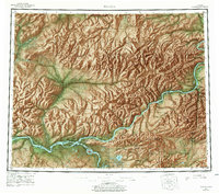
The Yukon River dominates this subarctic landscape, carving a deep path through the Ray Mountains and past the Rampart Ridge. This 1960s-era geography captures a region defined by its reliance on river transport and winter travel, notably the Tanana Allakaket Winter Trail and various Tractor Trails that crisscross the interior. Significant human activity is concentrated at Manley Hot Springs and Rampart, while evidence of the region's mining heritage is found at scattered Placer Mine sites and the settlement of Tofty.
Find a feature on this map
177 named features on this map. Tap any name to fly to it.
Don’t see what you’re looking for? This feature index may not catch every label — zoom into the map to look around manually.
Map Details
Editions of this 1960 Tanana Map
4 editions found
Other maps of this area

1945 · Livengood
USGS Topo · 1:250,000

1948 · Kantishna River
USGS Topo · 1:250,000

1950 · Fairbanks
USGS Topo · 1:250,000

1951 · Kantishna River
USGS Topo · 1:250,000

1951 · Ruby
USGS Topo · 1:250,000

1951 · Fairbanks
USGS Topo · 1:250,000

1951 · Hughes
USGS Topo · 1:250,000

1951 · Melozitna
USGS Topo · 1:250,000

1951 · Bettles
USGS Topo · 1:250,000

1951 · Tanana
USGS Topo · 1:250,000