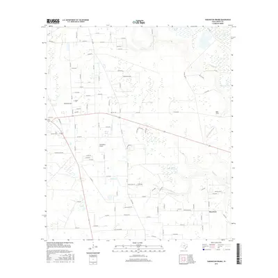
2016 Map of Tarkington Prairie
USGS Topo · Published 2016About this map
Tarkington Prairie and the community of Macedonia anchor this portrait of the coastal plain landscape in southeast Texas. The map reveals a complex hydrologic network defined by sluggish water bodies and drainage channels, including Gaylor Lake, Silver Bit Lake, and Palmer Lake. Small family-named landmarks like the Boothe Cem and Lums Cem provide anchor points for genealogists researching the local lineage of Liberty County. The terrain is characterized by intricate drainage features such as Indian Gulley and Thickets Cr, which wind through the wooded areas of Tarkington Woods. The road network, including the prominent FM 787e and numerous county roads like Co RD 2212, reflects the rural development and land divisions of the early 21st century.
Find a feature on this map
103 named features on this map. Tap any name to fly to it.
Don’t see what you’re looking for? This feature index may not catch every label — zoom into the map to look around manually.
Map Details
Editions of this 2016 Tarkington Prairie Map
This is the sole edition of this map. No revisions or reprints were ever made.
Other maps of this area

1943 · Liberty
USGS Topo · 1:125,000

1954 · Beaumont
USGS Topo · 1:250,000

1955 · Rayburn
USGS Topo · 1:62,500

1955 · Liberty
USGS Topo · 1:62,500

1957 · Beaumont
USGS Topo · 1:250,000

1958 · Cleveland
USGS Topo · 1:24,000

1958 · Westcott
USGS Topo · 1:24,000

1959 · Plum Grove
USGS Topo · 1:24,000

1984 · Beaumont
USGS Topo · 1:250,000
1984 · Rayburn
USGS Topo · 1:24,000