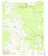
1984 Map of Tarkington Prairie
USGS Topo · Published 1985About this map
Tarkington Prairie emerges as a distinct settlement pattern in Liberty County on this mid-1980s topographic record. The landscape is defined by its low-lying hydrology, where Marsh Branch and Davis Bayou drain the flatlands. This provisional survey highlights the community of Tarkington Prairie as the central hub of activity, surrounded by a network of drainage features such as Board Slough and Deer Gully. The presence of several Cem locations suggests long-standing family ties and historical burial grounds typical of rural Texas prairies. The mapping also notes contemporary infrastructure, including a Sewage Disposal site, reflecting the transition of the area toward modern utility management while maintaining its agricultural and residential character. Significant waterways like Gaylor Creek provide insight into the natural drainage basins that shaped early settlement in this part of Liberty County.
Find a feature on this map
9 named features on this map. Tap any name to fly to it.
Don’t see what you’re looking for? This feature index may not catch every label — zoom into the map to look around manually.
Map Details
Editions of this 1984 Tarkington Prairie Map
This is the sole edition of this map. No revisions or reprints were ever made.
Other maps of this area

1943 · Liberty
USGS Topo · 1:125,000

1954 · Beaumont
USGS Topo · 1:250,000

1955 · Rayburn
USGS Topo · 1:62,500

1955 · Liberty
USGS Topo · 1:62,500

1957 · Beaumont
USGS Topo · 1:250,000

1958 · Cleveland
USGS Topo · 1:24,000

1958 · Westcott
USGS Topo · 1:24,000

1959 · Plum Grove
USGS Topo · 1:24,000

1984 · Beaumont
USGS Topo · 1:250,000
1984 · Rayburn
USGS Topo · 1:24,000