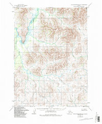
1954 Map of Taylor Mountains B-2
USGS Topo · Published 1987About this map
The Nushagak River winds through the northwestern reaches of this mid-century survey, creating the prominent oxbow known as Big Bend. This landscape is defined by its drainages, where several creek systems converge toward the main river valley. Along the banks of the Nushagak, isolated Cabin sites suggest the seasonal dwellings and trapping outposts that sustained life in the Taylor Mountains during the 1950s. To the east, the terrain is marked by the headwaters and courses of Portage Creek and Moose Creek, which carve through the higher elevations. Other significant waterways such as Crooked Creek and McGeary Creek establish the drainage patterns of the western slopes, providing a clear picture of the hydrological network before the later 1980s revisions were finalized.
Find a feature on this map
7 named features on this map. Tap any name to fly to it.
Don’t see what you’re looking for? This feature index may not catch every label — zoom into the map to look around manually.
Map Details
Editions of this 1954 Taylor Mountains B-2 Map
2 editions found
Other maps of this area

1950 · Taylor Mountains
USGS Topo · 1:250,000

1951 · Taylor Mountains
USGS Topo · 1:250,000

1954 · Taylor Mountains
USGS Topo · 1:250,000
1954 · Taylor Mountains B-2
USGS Topo · 1:63,360

1954 · Taylor Mountains C-1
USGS Topo · 1:63,360

1954 · Taylor Mountains B-1
USGS Topo · 1:63,360

1954 · Taylor Mountains C-3
USGS Topo · 1:63,360

1954 · Taylor Mountains A-2
USGS Topo · 1:63,360
1954 · Taylor Mountains C-2
USGS Topo · 1:63,360
1954 · Taylor Mountains A-3
USGS Topo · 1:63,360