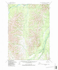
1954 Map of Taylor Mountains C-7
USGS Topo · Published 1987About this map
The Kogrukluk River and Chukowan River systems dominate this interior landscape, which was mapped by the Defense Mapping Agency using aerial photography from the mid-1950s. The terrain is characterized by a dense network of drainages, including the prominent Enatalik Creek in the north and the winding Kashioli Creek and Maka Creek to the south. Notable topographic markers such as Enata and Bairo stand above the drainage basins, providing orientation in a region defined by its complex hydrology and lack of established roads or trails. This 1954 field-annotated survey captures the raw state of the Alaskan interior before modern development, showing the natural flow of Bairo Creek and its surrounding marshlands precisely as they were recorded at the height of post-war exploration.
Find a feature on this map
8 named features on this map. Tap any name to fly to it.
Don’t see what you’re looking for? This feature index may not catch every label — zoom into the map to look around manually.
Map Details
Editions of this 1954 Taylor Mountains C-7 Map
2 editions found
Other maps of this area

1950 · Taylor Mountains
USGS Topo · 1:250,000

1951 · Taylor Mountains
USGS Topo · 1:250,000

1954 · Taylor Mountains
USGS Topo · 1:250,000

1954 · Taylor Mountains D-8
USGS Topo · 1:63,360

1954 · Taylor Mountains D-6
USGS Topo · 1:63,360

1954 · Taylor Mountains B-8
USGS Topo · 1:63,360

1954 · Taylor Mountains B-7
USGS Topo · 1:63,360
1954 · Taylor Mountains C-7
USGS Topo · 1:63,360

1954 · Taylor Mountains B-6
USGS Topo · 1:63,360
1954 · Taylor Mountains D-7
USGS Topo · 1:63,360