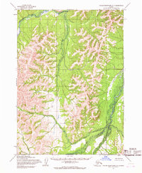
1954 Map of Taylor Mountains C-7
USGS Topo · Published 1968About this map
Chukowan River flows through a landscape of significant relief within the Taylor Mountains during the mid-1950s. This survey, compiled from aerial photography taken in 1953 and 1955, illustrates an era of remote Alaskan surveying where land lines remained largely unsurveyed and unmarked by the Bureau of Land Management. The terrain is defined by the drainage patterns of Enatalik Creek and Kashioli Creek, with localized elevations named Enata and Bairo. The intricate contour work reflects the hydrology of the Dillingham region, tracing the descent of Maka Creek and other tributaries as they navigate the ridges and basins of this subarctic wilderness.
Find a feature on this map
7 named features on this map. Tap any name to fly to it.
Don’t see what you’re looking for? This feature index may not catch every label — zoom into the map to look around manually.
Map Details
Editions of this 1954 Taylor Mountains C-7 Map
2 editions found
Other maps of this area

1950 · Taylor Mountains
USGS Topo · 1:250,000

1951 · Taylor Mountains
USGS Topo · 1:250,000

1954 · Taylor Mountains
USGS Topo · 1:250,000

1954 · Taylor Mountains D-8
USGS Topo · 1:63,360

1954 · Taylor Mountains D-6
USGS Topo · 1:63,360

1954 · Taylor Mountains B-8
USGS Topo · 1:63,360

1954 · Taylor Mountains B-7
USGS Topo · 1:63,360

1954 · Taylor Mountains B-6
USGS Topo · 1:63,360
1954 · Taylor Mountains D-7
USGS Topo · 1:63,360

1954 · Taylor Mountains C-6
USGS Topo · 1:63,360